Skip all navigation and jump to content Jump to site navigation Jump to section navigation.
NASA Logo - Goddard Space Flight Center + Visit NASA.gov
HOME PROJECTS RESOURCES SEARCH MAP

+ Advanced Search
Home
Home
View Most Recently Released Imagery
View Gallery of Imagery: A topical collection of SVS Imagery
Search Imagery by the keywords assigned to it
Search Imagery by the instruments that supplied data for a visualization product
Search Imagery by the series of visualizations that have been produced
Search Imagery by the scientist providing the data used in a visualization product
Search Imagery by the animator that created the product
Search Imagery by the identification number assigned to the visualization product
See other search options
Learn about the SVS Image Server
  + About the Server
  + Animation List
  + How to Use the Server


  + RSS Feeds
  + Podcasts


  + Opportunities
blank image
Previous Animation
Groundwater Depletion in India Revealed by GRACE

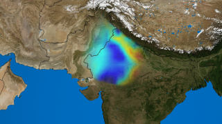
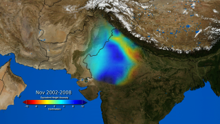
Scientists using data from NASA’s Gravity Recovery and Climate Experiment (GRACE) have found that the groundwater beneath Northern India has been receding by as much as one foot per year over the past decade. After examining many environmental and climate factors, the team of hydrologists led by Matt Rodell of NASA’s Goddard Space Flight Center, Greenbelt, Md. concluded that the loss is almost entirely due to human consumption.

Groundwater comes from the natural percolation of precipitation and other surface waters down through Earth’s soil and rock, accumulating in aquifers – cavities and layers of porous rock, gravel, sand, or clay. In some subterranean reservoirs, the water may be thousands to millions of years old; in others, water levels decline and rise again naturally each year. Groundwater levels do not respond to changes in weather as rapidly as lakes, streams, and rivers do. So when groundwater is pumped for irrigation or other uses, recharge to the original levels can take months or years.

More than 109 cubic km (26 cubic miles) of groundwater disappeared from the region's aquifers between 2002 and 2008 -- double the capacity of India's largest surface water reservoir, the Upper Wainganga, and triple that of Lake Mead, the largest manmade reservoir in the U.S.

The animation shown here depicts the change in groundwater levels as measured each November between 2002 to 2008.


Groundwater depletion, with color bar    Groundwater depletion, with color bar
Duration: 30.0 seconds
Available formats:
  1280x720 (60 fps) Frames (W dates)
  1280x720 (30 fps) Frames (W dates)
  512x288 (30 fps) MPEG-1   7 MB
  1280x720 (30 fps) MPEG-2   62 MB
  1280x720 (30 fps) MPEG-4   1 MB
  320x180     PNG           267 KB
  160x80       PNG           63 KB
  80x40         PNG           16 KB
How to play our movies


Groundwater depletion, without color bar    Groundwater depletion, without color bar
Duration: 30.0 seconds
Available formats:
  1280x720 (60 fps) Frames (Wo dates)
  1280x720 (30 fps) Frames (Wo dates)
  512x288 (30 fps) MPEG-1   5 MB
  1280x720 (30 fps) MPEG-2   28 MB
  1280x720 (30 fps) MPEG-4   1 MB
  320x180     PNG           271 KB
  160x80       PNG           63 KB
  80x40         PNG           16 KB
How to play our movies


Colorbar    Colorbar

Available formats:
  1200 x 250       TIFF 1 MB
  320 x 66           PNG       12 KB


Dates    Dates

Available formats:
  592 x 137         TIFF   317 KB
  320 x 74           PNG         9 KB

Animation Number:3623
Completed:2009-08-02
Animator:Trent L. Schindler (UMBC) (Lead)
Scientist:Matthew Rodell (UMBC)
Data Collected:2002 -2008
Goddard TV Tape:G2009-078 -- NASA Satellites Unlock Secret to Northern India''s Vanishing Water
 
 
Please give credit for this item to
NASA/Goddard Space Flight Center Scientific Visualization Studio


Back to Top

USA.gov logo - the U.S. Government's official Web portal. + Privacy Policy and Important Notices
+ Reproduction Guidelines
NASA NASA Official:
SVS Contact:
Curator: