|
|
 |
Landsat Image Mosaic of Antarctica Graphic
|
|
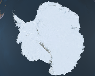
This large resolution graphic was created to display a 10 foot by 7 foot exhibition for the Landsat Image Mosaic of Antarctica (LIMA) project at the Antarctic Treaty Consultative Meeting (ATCM) in Baltimore, Maryland on April 16-17, 2009. This meeting marks the 50th Anniversary of the Antarctic Treaty. After this meeting, the printed image will be displayed in building 33 of Goddard Space Flight Center in Greenbelt, Maryland. The Landsat Image Mosaic of Antarctica (LIMA) is a data product funded by the National Science Foundation (NSF) and jointly produced by the U.S. Geological Survey (USGS), the British Antarctic Survey (BAS), and the National Aeronautics and Space Administration (NASA). The LIMA data shown here uses the pan-chromatic band and has a resolution of 15 meters per pixel. The LandSat satellite does not fly over the South Pole so the hole has been filled with data from NASA's MODIS Mosaic of Antarctica (MOA).
|
|

|
|
This image is the high resolution image of Antarctica shown using the Landsat Image Mosaic of Antarctica data.
Available formats:
36000 x 25200
TIFF
683 MB
320 x 256
PNG
72 KB
160 x 80
PNG
58 KB
80 x 40
PNG
14 KB
|
|
|
|
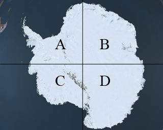
This element contains a very high resolution image divided into four panels. The panels are labeled with the letters A, B, C and D. The letters and lines are shown at the left for information purposes only, and are not in the downloaded images.
Available formats:
18000 x 12600
TIFF
173 MB
18000 x 12600
TIFF
173 MB
18000 x 12600
TIFF
154 MB
18000 x 12600
TIFF
182 MB
320 x 256
PNG
75 KB
|
|
|
Back to Top
|
|
|
|

