Skip all navigation and jump to content Jump to site navigation Jump to section navigation.
NASA Logo - Goddard Space Flight Center + Visit NASA.gov
HOME PROJECTS RESOURCES SEARCH MAP

+ Advanced Search
Home
Home
View Most Recently Released Imagery
View Gallery of Imagery: A topical collection of SVS Imagery
Search Imagery by the keywords assigned to it
Search Imagery by the instruments that supplied data for a visualization product
Search Imagery by the series of visualizations that have been produced
Search Imagery by the scientist providing the data used in a visualization product
Search Imagery by the animator that created the product
Search Imagery by the identification number assigned to the visualization product
See other search options
Learn about the SVS Image Server
  + About the Server
  + Animation List
  + How to Use the Server


  + RSS Feeds
  + Podcasts


  + Opportunities
blank image
Previous Animation
Next Animation
LRO Ground Track

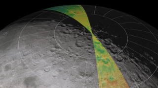
A satellite's ground track shows the path of its orbit on the surface of the parent body. Lunar Reconnaissance Orbiter will be placed in a nearly circular polar orbit about 50 kilometers (31 miles) above the surface of the Moon, completing each orbit in a little less than two hours. The orientation of this orbit remains fixed in space, relative to the stars, while the Moon slowly rotates beneath it as they travel together around the Earth, allowing LRO to scan the entire surface of the Moon every two weeks.

As this animation shows, the density of the ground coverage provided by a polar orbit is greatest at the poles. For the Moon, this is also where a great deal of current interest lies, since permanently shadowed areas at the poles may harbor water ice. This is also where some high-altitude areas are in gentle but perennial sunlight, providing the lighting and power supply for extended human exploration.

The animation depicts LRO's ground track over a period of seven days (89 orbits). The elevation map comprises low-resolution data from a number of sources, including the Clementine and JAXA/SELENE spacecraft, combined with high-resolution insets for the regions near the poles. The surface color is derived from photographs taken by Clementine.


LRO ground track flyover    LRO ground track flyover
Duration: 1.2 minutes
Available formats:
  1280x720 (30 fps) Frames (No Clock)
  320x180     PNG           253 KB
  160x80       PNG           61 KB
  80x40         PNG           15 KB
  512x288 (30 fps) MPEG-1   23 MB
  1280x720 (30 fps) MPEG-2   84 MB
  1280x720 (30 fps) MPEG-4   11 MB
How to play our movies


The same animation, with a readout of elapsed time and orbit number.    The same animation, with a readout of elapsed time and orbit number.
Duration: 1.2 minutes
Available formats:
  1280x720 (30 fps) Frames (Clock)
  320x180     PNG           254 KB
  512x288 (30 fps) MPEG-1   23 MB
  1280x720 (30 fps) MPEG-2   87 MB
  1280x720 (30 fps) MPEG-4   11 MB
How to play our movies

Animation Number:3576
Completed:2009-04-29
Animators:Ernie Wright (UMBC) (Lead)
 Marte Newcombe (GST)
Producer:Andrew Freeberg (NASA/GSFC)
Scientist:Richard Vondrak (NASA/GSFC)
Platforms/Sensors/Data Sets:KAGUYA/Laser Altimeter (LALT)/DEM (2007-12-30 to 2008-03-31)
 Tycho DEM (1998)
 Unified Lunar Control Network 2005 (1970 to 2005)
Series:The Moon
 LRO Pre-launch
Keywords:
SVS >> Elevation data
SVS >> False Color
SVS >> HDTV
SVS >> Moon
SVS >> North Pole
SVS >> South Pole
SVS >> Orbit
SVS >> Lunar Reconaissance Orbiter
 
 
Please give credit for this item to
NASA/Goddard Space Flight Center Scientific Visualization Studio. Some elevation data provided by JAXA/KAGUYA(SELENE).


Back to Top

USA.gov logo - the U.S. Government's official Web portal. + Privacy Policy and Important Notices
+ Reproduction Guidelines
NASA NASA Official:
Content Contact:
Curator: