|
|
 |
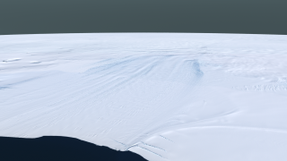
Landsat Image Mosaic of Antarctica Flyover of Pine Island Glacier
|
|
The Pine Island Glacier is the largest discharger of ice in Antarctica and the continent's fastest moving glacier. This area of the West Antarctic Ice Sheet is also believed to be the most susceptible to collapse. The evolution of this glacier is therefore of great interest to the scientific community. It is an area of Antarctica which is experiencing rapid changes. The grounding line of Pine Island Glacier is retreating, the glacier is thinning rapidly, and its ice flow is accelerating. Additionally, the sea ice cover in front of the glacier has been decreasing steadily for several decades. The Landsat Image Mosaic of Antarctica (LIMA) is a data product funded by the National Science Foundation (NSF) and jointly produced by the U.S. Geological Survey (USGS), the British Antarctic Survey (BAS), and the National Aeronautics and Space Administration (NASA). The LIMA data shown here uses the pan-chromatic band and has a resolution of 15 meters per pixel. The 13 swaths used to generate this sample mosaic where acquired between December 25, 1999 and December 31, 2001. The elevation data shown has no vertical exaggeration (1x) and is courtesy of the Radarsat Antarctic Mapping Project (RAMP) Digital Elevation Model (DEM).
|
|
|
|
This is the Pine Island Glacier which is a broad glacier flowing WNW along the south side of the Hudson Mountains into Pine Island Bay, Amundsen Sea.
Duration: 1.1 minutes
Available formats:
512x288 (30 fps)
MPEG-1
9 MB
1280x720 (60 fps)
Frames
320x180
PNG
217 KB
160x80
PNG
56 KB
80x40
PNG
14 KB
1280x720 (30 fps)
Frames
2667x1500
TIFF
3 MB
1280x720 (29.97 fps)
MPEG-4
63 MB
640x360 (30 fps)
MPEG-4
10 MB
1280x720 (60 fps)
MPEG-4
51 MB
How to play our movies
|
|

|
|
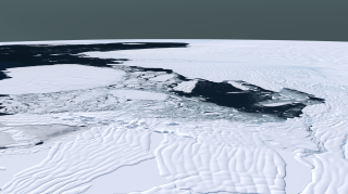
Iceberg factory on Thwaites Glacier (75 °S, 108°W) Accelerated motion at the seaward edge of the glacier and flexing of the floating ice shelf by ocean tides combine to create rows of weaker ice. Eventually a line of weakness fails and a large plate of ice is torn loose from the glacier creating a tabular iceberg which can be as much as a hundred kilometers across but is usually only a few hundred meters thick. These large icebergs can bash into each other like buses in a crowded parking lot before coming free in the open ocean.
Available formats:
2667 x 1500
TIFF
4 MB
320 x 179
PNG
271 KB
|
|

|
|
An Ice Shelf near Pine Island Glacier - Ice sheets matter because they can change sea level---fast. When ice sheets grow, ocean level sinks. This usually happens very slowly because ice sheet growth is limited by the amount of snow that falls. When ice sheets shrink, sea level rises and records of past sea level show this happens generally faster than ice sheet growth, with periods of very rapid sea level rise indicating very rapid loss of ice.
Available formats:
2667 x 1500
TIFF
3 MB
320 x 179
PNG
248 KB
|
|
|
Back to Top
|
|
|
|

