Skip all navigation and jump to content Jump to site navigation Jump to section navigation.
NASA Logo - Goddard Space Flight Center + Visit NASA.gov
HOME PROJECTS RESOURCES SEARCH MAP

+ Advanced Search
Home
Home
View Most Recently Released Imagery
View Gallery of Imagery: A topical collection of SVS Imagery
Search Imagery by the keywords assigned to it
Search Imagery by the instruments that supplied data for a visualization product
Search Imagery by the series of visualizations that have been produced
Search Imagery by the scientist providing the data used in a visualization product
Search Imagery by the animator that created the product
Search Imagery by the identification number assigned to the visualization product
See other search options
Learn about the SVS Image Server
  + About the Server
  + Animation List
  + How to Use the Server


  + RSS Feeds
  + Podcasts


  + Opportunities
blank image
Previous Animation
Next Animation
United States Mean Population Center, 1790-2000 (WMS)

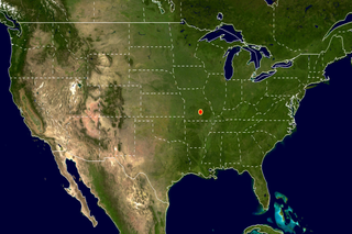
The mean center of population, traditionally referred to as the center of population, is provided for each census in the United States since 1790. The mean center of population is the point at which an imaginary, flat, weightless, and rigid map of the United States would balance if weights of identical value were placed on it so that each weight represented the location of one person. The mean center of population based on the 2000 census results is located in Phelps County, Missouri. For a complete list of the mean center of population for each census since 1790, and for a more detailed description of how these values are calculated, see http://www.census.gov/geo/www/cenpop/calculate2k.pdf.

This animation shows the mean population center of the United States for each census from 1790-2000.    This animation shows the mean population center of the United States for each census from 1790-2000.
Duration: 9.0 seconds
Available formats:
  1024x512   Frames
  720x480 (29.97 fps) MPEG-2   8 MB
  320x213     PNG           279 KB
  80x40         PNG           11 KB
  320x240 (30 fps) MPEG-1   2 MB
  640x480 (30 fps) MPEG-1   3 MB
  320x240 (30 fps) X-FLV       610 KB
How to play our movies

This product is available through our Web Map Service.   Click here to learn more.
Animation Number:3163
Completed:2005-05-23
Animator:Eric Sokolowsky (GST) (Lead)
Platform/Sensor/Data Set:Airborne Topographic Mapper
Series:WMS
Keywords:
DLESE >> Human geography
GCMD >> EARTH SCIENCE >> Human Dimensions >> Population >> Population Distribution
View Animation in Google Earth Google Earth KML file is available here.
DEPC Metadata is available here.
 
 
Please give credit for this item to
NASA/Goddard Space Flight Center
Scientific Visualization Studio


Back to Top

USA.gov logo - the U.S. Government's official Web portal. + Privacy Policy and Important Notices
+ Reproduction Guidelines
NASA NASA Official:
SVS Contact:
Curator: