USGS - science for a changing world

Minnesota Water Science Center

  Home   Information/Data   Projects   Publications   Drought   Flood   NAWQA   Office   Contact   Other USGS
Bemidji.

Bemidji Crude-Oil Project

Minnesota PROJECTS

USGS IN YOUR STATE

USGS Water Science Centers are located in each state.

There is a USGS Water Science Center office in each State. Washington Oregon California Idaho Nevada Montana Wyoming Utah Colorado Arizona New Mexico North Dakota South Dakota Nebraska Kansas Oklahoma Texas Minnesota Iowa Missouri Arkansas Louisiana Wisconsin Illinois Mississippi Michigan Indiana Ohio Kentucky Tennessee Alabama Pennsylvania West Virginia Georgia Florida Caribbean Alaska Hawaii New York Vermont New Hampshire Maine Massachusetts South Carolina North Carolina Rhode Island Virginia Connecticut New Jersey Maryland-Delaware-D.C.

Bemidji Crude-Oil Research Project

Bemidji researchers checking and downloading realtime groundwater and unsaturated zone data. 
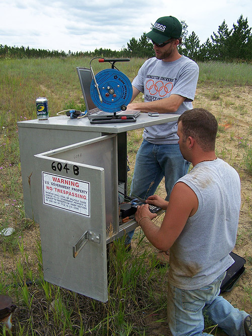
The objective of the project is to improve the understanding of the mobilization, transport, and fate of crude oil in the shallow subsurface. The U.S. Geological Survey Toxic Substances Hydrology Program began an interdisciplinary research project in 1983 at the site of a crude-oil spill near Bemidji, Minnesota. Research is conducted within four broad disciplines by scientists from the U.S. Geological Survey and from several academic institutions. Currently, about 10 research projects are active. A fact sheet describing results from the Bemidji Toxics project is available.

The spill occurred in 1979 when a pipeline transporting crude oil broke. After cleanup efforts were completed in 1980, about 400,000 liters of oil remained in the unsaturated zone and near the water table. This continues to be a source of contaminants to a shallow outwash aquifer. The oil is moving as a separate fluid phase, as dissolved petroleum constituents in ground water, and as vapors in the unsaturated zone. Native microbes are converting the petroleum derivatives into carbon dioxide, methane, and other biodegradation products.

USGS Home Water Resources Biology Geography Geology Geospatial

Accessibility FOIA Privacy Policies and Notices

Take Pride in America logo USA.gov logo U.S. Department of the Interior | U.S. Geological Survey
URL: http://mn.water.usgs.gov/projects/bemidji/index.html
Page Contact Information: Webmaster
Page Last Modified: Tuesday, 17-Feb-2009 14:45:05 EST

05338500: Flow=1560cfs,Stage=4.64ft,Floodstage=9.0ft,2009-08-25 19:00,High,SNAKE RIVER NEAR PINE CITY, MN 05340500: Flow=5810cfs,Stage=4.36ft,2009-08-25 19:15,>90,ST. CROIX RIVER AT ST. CROIX FALLS, WI 05291000: Flow=34cfs,Stage=1.79ft,2009-08-25 20:00,>90,WHETSTONE RIVER NEAR BIG STONE CITY, SD 05290000: Flow=23cfs,Stage=9.96ft,Floodstage=17.0ft,2009-08-25 20:45,>90,LITTLE MINNESOTA RIVER NEAR PEEVER, SD 05133500: Flow=28900cfs,Stage=11.61ft,2009-08-25 20:30,>90,RAINY RIVER AT MANITOU RAPIDS, MN 05094000: Flow=86cfs,Stage=4.07ft,2009-08-25 20:00,>90,SOUTH BRANCH TWO RIVERS AT LAKE BRONSON, MN 05092000: Flow=5360cfs,Stage=13.87ft,Floodstage=32.0ft,2009-08-25 20:00,>90,RED RIVER OF THE NORTH AT DRAYTON, ND 05082500: Flow=4210cfs,Stage=17.48ft,Floodstage=28.0ft,2009-08-25 20:30,>90,RED RIVER OF THE NORTH AT GRAND FORKS, ND 05069000: Flow=74cfs,Stage=4.83ft,Floodstage=20.0ft,2009-08-25 19:00,>90,SAND HILL RIVER AT CLIMAX, MN 05062500: Flow=257cfs,Stage=2.94ft,Floodstage=10.0ft,2009-08-25 19:00,>90,WILD RICE RIVER AT TWIN VALLEY, MN 05062000: Flow=273cfs,Stage=6.15ft,Floodstage=12.0ft,2009-08-25 20:30,>90,BUFFALO RIVER NEAR DILWORTH, MN 05061500: Flow=78cfs,Stage=7.47ft,Floodstage=12.0ft,2009-08-25 20:00,>90,SOUTH BRANCH BUFFALO RIVER AT SABIN, MN 05054000: Flow=1010cfs,Stage=15.09ft,Floodstage=18.0ft,2009-08-25 20:15,>90,RED RIVER OF THE NORTH AT FARGO, ND 05053000: Flow=119cfs,Stage=1.22ft,Floodstage=10.0ft,2009-08-25 20:15,>90,WILD RICE RIVER NR ABERCROMBIE, ND 05046000: Flow=689cfs,Stage=3.38ft,2009-08-25 20:00,>90,OTTER TAIL RIVER BL ORWELL D NR FERGUS FALLS, MN 05336700: Flow=980cfs,Stage=5.57ft,2009-08-25 19:00,76-90,KETTLE RIVER BELOW SANDSTONE, MN 05311000: Flow=780cfs,Stage=4.68ft,Floodstage=14.0ft,2009-08-25 20:00,76-90,MINNESOTA RIVER AT MONTEVIDEO, MN 05301000: Flow=659cfs,Stage=22.71ft,2009-08-25 20:00,76-90,MINNESOTA RIVER NEAR LAC QUI PARLE, MN 05294000: Flow=125cfs,Stage=4.76ft,2009-08-25 20:00,76-90,POMME DE TERRE RIVER AT APPLETON, MN 05293000: Flow=20cfs,Stage=1.93ft,2009-08-25 20:00,76-90,YELLOW BANK RIVER NEAR ODESSA, MN 05280000: Flow=947cfs,Stage=3.39ft,Floodstage=10.0ft,2009-08-25 20:00,76-90,CROW RIVER AT ROCKFORD, MN 05247500: Flow=1050cfs,2009-08-25 20:30,Stage=3.79ft,2009-08-25 07:00:00,76-90,CROW WING RIVER NEAR PILLAGER, MN 05131500: Flow=878cfs,Stage=3.92ft,2009-08-25 20:30,76-90,LITTLE FORK RIVER AT LITTLEFORK, MN 05112000: Flow=420cfs,Stage=4.09ft,2009-08-25 19:00,76-90,ROSEAU RIVER BELOW STATE DITCH 51 NR CARIBOU, MN 05107500: Flow=274cfs,Stage=4.73ft,2009-08-25 19:00,76-90,ROSEAU RIVER AT ROSS, MN 05106000: Flow=53cfs,Stage=3.39ft,2009-08-25 17:00,76-90,SPRAGUE CREEK NEAR SPRAGUE, MANITOBA, CANADA 05104500: Flow=77cfs,Stage=5.23ft,2009-08-25 19:30,76-90,ROSEAU RIVER BELOW SOUTH FORK NEAR MALUNG, MN 05087500: Flow=12cfs,2009-08-25 17:30,0000-00-00 00:00:00,76-90,MIDDLE RIVER AT ARGYLE, MN 05078500: Flow=199cfs,Stage=2.71ft,2009-08-25 20:00,76-90,CLEARWATER RIVER AT RED LAKE FALLS, MN 05078230: Flow=55cfs,Stage=4.84ft,2009-08-25 20:30,76-90,LOST RIVER AT OKLEE, MN 05074500: Flow=783cfs,Stage=71.62ft,2009-08-25 20:00,76-90,RED LAKE RIVER NEAR RED LAKE, MN 05064500: Flow=2100cfs,Stage=7.54ft,Floodstage=26.0ft,2009-08-25 20:00,76-90,RED RIVER OF THE NORTH AT HALSTAD, MN 05064000: Flow=338cfs,Stage=6.17ft,Floodstage=20.0ft,2009-08-25 20:00,76-90,WILD RICE RIVER AT HENDRUM, MN 05061000: Flow=60cfs,2009-08-25 18:30,Stage=4.55ft,2009-06-30 10:30:00,Floodstage=7.0ft,76-90,BUFFALO RIVER NEAR HAWLEY, MN 05051522: Flow=1020cfs,Stage=11.43ft,2009-08-25 18:45,76-90,RED RIVER OF THE NORTH AT HICKSON, ND 05051500: Flow=779cfs,Stage=5.52ft,Floodstage=10.0ft,2009-08-25 20:00,76-90,RED RIVER OF THE NORTH AT WAHPETON, ND 04024430: Flow=366cfs,Stage=6.58ft,Floodstage=20.0ft,2009-08-25 19:00,76-90,NEMADJI RIVER NEAR SOUTH SUPERIOR, WI 04024000: Flow=1790cfs,Stage=3.83ft,Floodstage=10.5ft,2009-08-25 20:30,76-90,ST. LOUIS RIVER AT SCANLON, MN 05320000: Flow=102cfs,Stage=1.58ft,2009-08-25 20:15,10-24,BLUE EARTH RIVER NEAR RAPIDAN, MN 05319500: Flow=20cfs,Stage=0.61ft,2009-08-25 19:00,10-24,WATONWAN RIVER NEAR GARDEN CITY, MN 05227500: Flow=841cfs,Stage=2.71ft,Floodstage=12.0ft,2009-08-25 20:00,10-24,MISSISSIPPI RIVER AT AITKIN, MN 05211000: Flow=358cfs,Stage=3.28ft,2009-08-25 20:00,10-24,MISSISSIPPI RIVER AT GRAND RAPIDS, MN 06482610: Flow=30cfs,Stage=2.02ft,Floodstage=8.5ft,2009-08-25 20:45,25-75,SPLIT ROCK CR AT CORSON,SD 05476000: Flow=152cfs,Stage=3.31ft,Floodstage=12.0ft,2009-08-25 20:00,25-75,DES MOINES RIVER AT JACKSON, MN 05457000: Flow=89cfs,Stage=2.69ft,2009-08-25 20:00,25-75,CEDAR RIVER NEAR AUSTIN, MN 05388250: Flow=379cfs,Stage=7.51ft,Floodstage=14.0ft,2009-08-25 20:00,25-75,Upper Iowa River near Dorchester, IA 05355200: Flow=335cfs,Stage=3.16ft,2009-08-25 20:00,25-75,CANNON RIVER AT WELCH, MN 05353800: Flow=84cfs,Stage=4.00ft,2009-08-25 17:00,25-75,STRAIGHT RIVER NEAR FARIBAULT, MN 05345000: Flow=39cfs,Stage=2.65ft,2009-08-25 18:30,25-75,VERMILLION RIVER NEAR EMPIRE, MN 05333500: Flow=777cfs,Stage=0.84ft,Floodstage=7.0ft,2009-08-25 19:15,25-75,ST. CROIX RIVER NEAR DANBURY, WI 05330000: Flow=1210cfs,Stage=5.09ft,Floodstage=25.0ft,2009-08-25 20:00,25-75,MINNESOTA RIVER NEAR JORDAN, MN 05327000: Flow=53cfs,Stage=2.89ft,2009-08-25 18:30,25-75,HIGH ISLAND CREEK NEAR HENDERSON, MN 05325000: Flow=1050cfs,Stage=2.74ft,Floodstage=22.0ft,2009-08-25 20:00,25-75,MINNESOTA RIVER AT MANKATO, MN 05320500: Flow=59cfs,Stage=1.04ft,2009-08-25 18:00,25-75,LE SUEUR RIVER NEAR RAPIDAN, MN 05317000: Flow=53cfs,Stage=2.50ft,Floodstage=11ft,2009-08-25 20:00,25-75,COTTONWOOD RIVER NEAR NEW ULM, MN 05316500: Flow=15cfs,Stage=1.58ft,Floodstage=6.0ft,2009-08-25 19:00,25-75,REDWOOD RIVER NEAR REDWOOD FALLS, MN 05313500: Flow=4.6cfs,Stage=2.20ft,2009-08-25 20:00,25-75,YELLOW MEDICINE RIVER NEAR GRANITE FALLS, MN 05304500: Flow=191cfs,Stage=1.46ft,2009-08-25 20:00,25-75,CHIPPEWA RIVER NEAR MILAN, MN 05300000: Flow=26cfs,Stage=5.11ft,2009-08-25 20:00,25-75,LAC QUI PARLE RIVER NEAR LAC QUI PARLE, MN 05288500: Flow=5230cfs,Stage=2.88ft,2009-08-25 20:00,25-75,MISSISSIPPI RIVER NEAR ANOKA, MN 05278000: Flow=38cfs,Stage=2.87ft,2009-08-25 20:00,25-75,MIDDLE FORK CROW RIVER NEAR SPICER, MN 05275000: Flow=178cfs,Stage=1.27ft,2009-08-25 19:00,25-75,ELK RIVER NEAR BIG LAKE, MN 05267000: Flow=2240cfs,Stage=8.69ft,2009-08-25 20:00,25-75,MISSISSIPPI RIVER NEAR ROYALTON, MN 05244000: Flow=377cfs,2009-08-25 20:00,Stage=3.02ft,2009-08-25 03:00:00,25-75,CROW WING RIVER AT NIMROD, MN 05132000: Flow=184cfs,Stage=3.19ft,2009-08-25 20:30,25-75,BIG FORK RIVER AT BIG FALLS, MN 05130500: Flow=60cfs,Stage=2.07ft,2009-08-25 17:30,25-75,STURGEON RIVER NEAR CHISHOLM, MN 05127500: Flow=625cfs,Stage=3.01ft,2009-08-25 20:30,25-75,BASSWOOD RIVER NEAR WINTON, MN 05124480: Flow=56cfs,Stage=3.02ft,2009-08-25 18:00,25-75,KAWISHIWI RIVER NEAR ELY, MN 05079000: Flow=1170cfs,Stage=6.21ft,Floodstage=15.0ft,2009-08-25 20:00,25-75,RED LAKE RIVER AT CROOKSTON, MN 05078000: Flow=113cfs,Stage=3.19ft,2009-08-25 20:00,25-75,CLEARWATER RIVER AT PLUMMER, MN 05076000: Flow=65cfs,Stage=5.09ft,2009-08-25 20:15,25-75,THIEF RIVER NEAR THIEF RIVER FALLS, MN 05067500: Flow=3.0cfs,Stage=4.13ft,Floodstage=14.0ft,2009-08-25 20:15,25-75,MARSH RIVER NEAR SHELLY, MN 05050000: Flow=0.62cfs,Stage=3.28ft,Floodstage=80.0ft,2009-08-25 20:00,25-75,BOIS DE SIOUX RIVER NEAR WHITE ROCK, SD 04015330: Flow=33cfs,Stage=2.92ft,2009-08-25 19:00,25-75,KNIFE RIVER NEAR TWO HARBORS, MN 04010500: Flow=172cfs,Stage=2.89ft,2009-08-25 20:30,25-75,PIGEON RIVER AT MIDDLE FALLS NR GRAND PORTAGE MN 464646092052900: Stage=601.72ft,2009-08-25 19:10:00,Not ranked,Rating being developed or revised,SUPERIOR BAY DULUTH SHIP CANAL AT DULUTH, MN 0531656290: Not ranked,Site discontinued,WEST FORK BEAVER CREEK AT 320 ST. NEAR BECHYN, MN 06604000: Stage=14.10ft,2009-08-25 18:45:00,Floodstage=17.0ft,Not ranked,Spirit Lake near Orleans, IA 06483290: Flow=67cfs,Stage=7.11ft,Floodstage=13.0ft,2009-08-25 20:15,Not ranked,Rock River below Tom Creek at Rock Rapids, IA 05475350: Stage=11.79ft,2009-08-25 20:00:00,Floodstage=19.0ft,Not ranked,DES MOINES RIVER ABOVE WINDOM, MN -DM4 05386400: Stage=31.17ft,2009-08-25 20:00:00,Not ranked,MISSISSIPPI RIVER AT BROWNSVILLE, MN 05385500: Stage=1.23ft,2009-08-25 20:00:00,Not ranked,SOUTH FORK ROOT RIVER NEAR HOUSTON, MN 05385000: Stage=3.30ft,2009-08-25 20:00:00,Floodstage=15.0ft,Not ranked,ROOT RIVER NEAR HOUSTON, MN 05384330: Stage=9.17ft,2009-08-25 13:00:00,Not ranked,ROOT RIVER ABOVE RUSHFORD, MN 05383950: Flow=180cfs,Stage=7.84ft,2009-08-25 21:00,Not ranked,ROOT RIVER NEAR PILOT MOUND, MN 05383075: Flow=442cfs,Stage=3.20ft,2009-08-25 19:00,Not ranked,LA CROSSE RIVER NEAR LA CROSSE, WI 05380509: Stage=3.11ft,2009-08-25 18:45:00,Not ranked,TANK CREEK NEAR GALESVILLE, WI 05378500: Stage=5.66ft,Floodstage=13.0ft,2009-08-25 20:00,Not ranked,Very low value,MISSISSIPPI RIVER AT WINONA, MN 05378490: Stage=5.92ft,2009-08-25 20:00:00,Not ranked,MISSISSIPPI RIVER AT LOCK AND DAM 5A NR WINONA, MN 05374000: Stage=5.74ft,2009-08-25 20:00:00,Floodstage=18.0ft,Not ranked,ZUMBRO RIVER AT ZUMBRO FALLS, MN 05372995: Flow=53cfs,Stage=2.19ft,Floodstage=14.0ft,2009-08-25 20:00,Not ranked,SOUTH FORK ZUMBRO RIVER AT ROCHESTER, MN 05346050: Stage=668.67ft,2009-08-25 17:00:00,Not ranked,CLEAR LAKE, EAST SIDE, AT PRAIRIE ISLAND, MN 05344850: Stage=674.88ft,2009-08-25 18:00:00,Not ranked,STURGEON LAKE, WEST SIDE, AT PRAIRIE ISLAND, MN 05344500: Stage=25.89ft,2009-08-25 20:00,Not ranked,Very low value,MISSISSIPPI RIVER AT PRESCOTT, WI 05344490: Flow=7190cfs,Stage=23.15ft,2009-08-25 20:30,Not ranked,ST. CROIX RIVER AT PRESCOTT, WI 05342000: Flow=189cfs,Stage=10.21ft,2009-08-25 19:15,Not ranked,KINNICKINNIC RIVER NEAR RIVER FALLS, WI 05336000: Stage=4.48ft,2009-08-25 20:00:00,Not ranked,ST. CROIX RIVER NEAR GRANTSBURG, WI 05331580: Stage=7.78ft,2009-08-25 20:45:00,Not ranked,MISSISSIPPI RIVER BELOW L&D #2 AT HASTINGS, MN 05331000: Stage=3.64ft,Floodstage=14.0ft,2009-08-25 20:15,Not ranked,Very low value,MISSISSIPPI RIVER AT ST. PAUL, MN 05330920: Flow=1960cfs,Stage=687.23ft,2009-08-25 20:45,Not ranked,MINNESOTA RIVER AT FORT SNELLING STATE PARK, MN 05326189: Not ranked,Site discontinued,SOUTH BRANCH RUSH RIVER AT CO RD 63 NR NORSELAND 05326180: Not ranked,Site discontinued,SOUTH BRANCH RUSH RIVER AT CO. 8 NR BERNADOTTE, MN 05320270: Flow=0.17cfs,Stage=4.13ft,2009-08-25 19:30,Not ranked,LITTLE COBB RIVER NEAR BEAUFORD, MN 05317200: Flow=14cfs,Stage=3.14ft,2009-08-25 13:00,Not ranked,LITTLE COTTONWOOD RIVER NEAR COURTLAND, MN 05316580: Flow=755cfs,Stage=9.19ft,2009-08-25 20:30,Not ranked,MINNESOTA RIVER AT MORTON, MN 05315000: Flow=17cfs,Stage=7.95ft,Floodstage=14.0ft,2009-08-25 13:00,Not ranked,REDWOOD RIVER NEAR MARSHALL, MN 05314510: Not ranked,Site discontinued,CHETOMBA CREEK NEAR RENVILLE, MN 05305000: Stage=35.79ft,2009-08-25 20:00:00,Not ranked,CHIPPEWA RIVER (TW) NEAR WATSON, MN 05304995: Stage=38.92ft,2009-08-25 20:00:00,Not ranked,CHIPPEWA R. (HW) ABOVE COUNTY RD 13 NR WATSON, MN 05292000: Flow=102cfs,Stage=2.18ft,Floodstage=10.0ft,2009-08-25 20:00,Not ranked,MINNESOTA RIVER AT ORTONVILLE, MN 05289800: Stage=12.91ft,2009-08-25 18:30:00,Not ranked,MINNEHAHA CREEK AT HIAWATHA AVE. IN MINNEAPOLIS,MN 05288705: Flow=9.0cfs,Stage=9.48ft,2009-08-25 21:00,Not ranked,SHINGLE CREEK AT QUEEN AVE IN MINNEAPOLIS, MN 05288696: Flow=0.33cfs,Stage=7.93ft,2009-08-25 18:00,Not ranked,SHINGLE CREEK TRIB. AT ZANE AVE. IN BROOKLYN PARK 05288580: Flow=31cfs,Stage=7.34ft,2009-08-25 20:30,Not ranked,RICE CREEK BLW OLD HWY. 8 IN MOUNDS VIEW, MN 05287890: Flow=49cfs,Stage=4.72ft,2009-08-25 17:00,Not ranked,ELM CREEK NR CHAMPLIN, MN 05286000: Flow=634cfs,Stage=3.29ft,2009-08-25 13:00,Not ranked,RUM RIVER NEAR ST. FRANCIS, MN 05284000: Stage=11.04ft,2009-08-25 00:00:00,Not ranked,MILLE LACS LAKE AT COVE BAY NEAR ONAMIA, MN 05270700: Flow=3160cfs,Stage=4.60ft,Floodstage=9.0ft,2009-08-25 19:30,Not ranked,MISSISSIPPI RIVER AT ST. CLOUD, MN 05270500: Flow=539cfs,Stage=2.54ft,Floodstage=6.0ft,2009-08-25 12:30,Not ranked,SAUK RIVER NEAR ST. CLOUD, MN 05245100: Flow=91cfs,Stage=1.85ft,Floodstage=6.0ft,2009-08-25 13:30,Not ranked,LONG PRAIRIE RIVER AT LONG PRAIRIE, MN 05243725: Flow=62cfs,Stage=1.61ft,2009-08-25 18:00,Not ranked,STRAIGHT RIVER NEAR PARK RAPIDS, MN 05242300: Flow=860cfs,Stage=5.30ft,Floodstage=13.0ft,2009-08-25 20:00,Not ranked,MISSISSIPPI RIVER AT BRAINERD, MN 05220600: Flow=666cfs,Stage=41.54ft,2009-08-25 20:00,Not ranked,MISSISSIPPI RIVER AT PALISADE, MN 05212700: Flow=84cfs,Stage=2.77ft,Floodstage=10.0ft,2009-08-25 19:00,Not ranked,PRAIRIE RIVER NEAR TACONITE, MN 05210000: Stage=73.71ft,2009-08-25 20:00:00,Not ranked,MISSISSIPPI R. AT DAYS HIGH LANDING NR DEER RIVER 05207600: Flow=217cfs,Stage=5.75ft,2009-08-25 20:00,Not ranked,MISSISSIPPI RIVER AT WILLOW BEACH AT BALL CLUB, MN 05205900: Stage=94.07ft,2009-08-25 20:00:00,Not ranked,LEECH LAKE AT SUGAR POINT NEAR FEDERAL DAM, MN 05200510: Flow=158cfs,Stage=2.97ft,2009-08-25 18:30,Not ranked,MISSISSIPPI RIVER NEAR BEMIDJI, MN 05140521: Stage=60.01ft,2009-08-25 20:30:00,Not ranked,LK OF THE WOODS @ SPRINGSTEEL IS NR. WARROAD, MN 05140520: Stage=60.02ft,2009-08-25 20:30:00,Not ranked,LAKE OF THE WOODS AT WARROAD, MN 05134200: Flow=111cfs,Stage=3.01ft,2009-08-25 20:00,Not ranked,RAPID RIVER NEAR BAUDETTE, MN 05129290: Flow=538cfs,Stage=17.51ft,2009-08-25 20:30,Not ranked,GOLD PORTAGE OUTLET FROM KABETOGAMA LK NR RAY,MN 05129115: Flow=810cfs,Stage=8.12ft,2009-08-25 20:30,Not ranked,VERMILION RIVER NR CRANE LAKE, MN 05126210: Flow=468cfs,Stage=4.51ft,2009-08-25 20:00,Not ranked,SOUTH KAWISHIWI R ABV WHITE IRON LAKE NR ELY, MN 05125000: Flow=141cfs,Stage=2.26ft,2009-08-25 18:00,Not ranked,SOUTH KAWISHIWI RIVER NEAR ELY, MN 05102490: Stage=16.31ft,2009-08-25 17:00:00,Not ranked,RED RIVER OF THE NORTH AT PEMBINA, ND 05085450: Flow=15cfs,Stage=5.50ft,2009-08-25 20:30,Not ranked,SNAKE RIVER ABOVE WARREN, MN 05085420: Not ranked,Site discontinued,SNAKE RIVER ABOVE RADIUM, MN 05083500: Stage=10.91ft,2009-08-25 20:15:00,Floodstage=26.0ft,Not ranked,RED RIVER OF THE NORTH AT OSLO, MN 05080000: Flow=1220cfs,Stage=13.23ft,2009-08-25 19:45,Not ranked,RED LAKE RIVER AT FISHER, MN 05078770: Flow=3.8cfs,Stage=1.96ft,2009-08-25 06:00,Not ranked,JUDICIAL DITCH 66 NEAR MARCOUX CORNERS, MN (SW6) 05078720: Flow=3.4cfs,Stage=2.31ft,2009-08-25 05:00,Not ranked,CO DITCH 140 ABV BR-6 IMP NR TILDEN JCT, MN (SW8) 05075000: Stage=5.50ft,2009-08-25 20:00:00,Floodstage=12.0ft,Not ranked,RED LAKE RIVER AT HIGH LANDING NR GOODRIDGE, MN 05074000: Stage=75.34ft,2009-08-25 20:00:00,Not ranked,LOWER RED LAKE NR RED LAKE, MN 05073650: Stage=76.43ft,2009-08-25 20:00:00,Not ranked,LOWER RED LAKE AT MOUTH BATTLE RIVER NR SAUM, MN 05073500: Stage=75.27ft,2009-08-25 20:00:00,Not ranked,UPPER RED LAKE AT WASKISH, MN 05070000: Flow=2860cfs,Stage=20.29ft,2009-08-25 20:15,Not ranked,RED RIVER OF THE NORTH NEAR THOMPSON, ND 05063398: Flow=33cfs,Stage=4.83ft,2009-08-25 20:30,Not ranked,S. BR. WILD RICE RIVER AT CO. RD. 27 NR FELTON, MN 05060400: Stage=70.04ft,2009-08-25 20:00:00,Not ranked,SHEYENNE RIVER AT HARWOOD, ND 05052500: Flow=2.0cfs,Stage=21.56ft,2009-08-25 20:30,Not ranked,ANTELOPE CREEK AT DWIGHT, ND 05051300: Flow=8.4cfs,Stage=6.31ft,2009-08-25 19:00,Not ranked,BOIS DE SIOUX RIVER NEAR DORAN, MN 05049995: Stage=71.52ft,2009-08-25 20:00:00,Not ranked,MUD LAKE ABOVE WHITE ROCK DAM NEAR WHITE ROCK, SD 05049000: Stage=76.72ft,2009-08-25 20:00:00,Floodstage=92.0ft,Not ranked,MUSTINKA RIVER ABOVE WHEATON, MN 05046475: Flow=6.4cfs,Stage=3.77ft,2009-08-25 19:00,Not ranked,OTTER TAIL RIVER DIVERSION AT BRECKENRIDGE, MN 05030500: Flow=428cfs,Stage=6.08ft,2009-08-25 19:00,Not ranked,OTTER TAIL RIVER NEAR ELIZABETH, MN 04021520: Stage=3.38ft,2009-08-25 20:00:00,Not ranked,Rating being developed or revised,STONEY BROOK AT PINE DRIVE NEAR BROOKSTON, MN Go to WaterWatch (offsite) for a larger map with additional options