
Monitoring Deformation in Yellowstone National Park
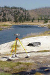 Continous recording and temporary deployments of
Global Positioning Systems (GPS) receivers and bench marks on
solid
monuments are employed at Yellowstone to precisely record their
positions (horizontal and vertical coordinates). The time variations
over days, months, years, etc. provide the velocity (in cm per year) of
the site relative to the rest of the points in Yellowstone and to the
rest of the North American continent. The velocity fields thus map
spatial variations of the ground due to such volcanic processes as
magma and hydrothermal transport and fault motions related to
earthquakes. Measurements of ground motions using GPS at Yellowstone
thus provides a method of monitoring its active volcanic and tectonic
processes that are necessary for understanding the properties and
locations of the sources as well as providing information on possible
premonitory motions that precede a volcanic or earthquake event.
Continous recording and temporary deployments of
Global Positioning Systems (GPS) receivers and bench marks on
solid
monuments are employed at Yellowstone to precisely record their
positions (horizontal and vertical coordinates). The time variations
over days, months, years, etc. provide the velocity (in cm per year) of
the site relative to the rest of the points in Yellowstone and to the
rest of the North American continent. The velocity fields thus map
spatial variations of the ground due to such volcanic processes as
magma and hydrothermal transport and fault motions related to
earthquakes. Measurements of ground motions using GPS at Yellowstone
thus provides a method of monitoring its active volcanic and tectonic
processes that are necessary for understanding the properties and
locations of the sources as well as providing information on possible
premonitory motions that precede a volcanic or earthquake event.
The continuously recorded GPS data are telemetered via radio and satellite links to the University of Utah for recording and processing.
GPS Deformation Data (from the University of Utah)
- GPS stations and time-series data for the Yellowstone region (click on station for data).
- 3-dimensional velocity field for the Yellowstone caldera from the University of Utah.
- Horizonal velocity field for the Yellowstone-Snake River Plain from the University of Utah.
- Station history, characteristics and status is available in a searchable archive courtesy of UNAVCO. Station names are shown in the Ground Motions and Time Series links above.
