
Images from the Volcano Hazards Program
The Volcano Hazards Program publishes a wide variety of materials including Images, Fact Sheets, Maps, Hazard Assessments, and Scientific articles.
-
Photoglossary
View pictures and definitions of volcanic terms.
-
Web Cams
See real-time images of several U.S. volcanoes.
-
Volcano Fact Sheets
Find Fact Sheets and posters on U.S. volcanoes. These are written for the general public.
-
VHP Update Feeds

Access our updates from a news reader.
-
Volcano Assessments
Read summaries of past volcanic activity and discussions of potential hazards.
-
Other products

Choose from a variety of other volcano products including lists of recent scientific publications.
Images from the Observatories
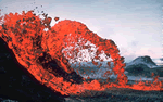
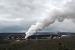
Images record volcanic activity and provide a basis for comparison. Each observatory collects and archives their own images. Below is a list of image archives on the observatory sites.
- The AVO image database includes images of Alaskan volcanoes and Alaska research. It is searchable by keywords.
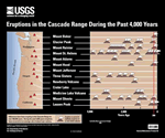
- The CVO photo archives page includes links to all Cascade volcanoes lots of great images of the Mount St. Helens eruptions.
- HVO Kilauea images.
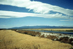
- The Long Valley Observatory image gallery includes pictures of the Long Valley Caldera area (Mammoth Mountain, Mono Lake, Mono Craters, Inyo Craters, and the Long Valley Caldera).
- Yellowstone Volcano Observatory (YVO) image gallery.
- Yellowstone aerial photography taken by a camera attached to a helium-filled balloon in September 2005.
