|
| Today's Convective Outlooks |
| Updated: Tue Aug 25 00:32:15 UTC 2009 |
| Current Convective Outlooks |
Current Day 1 Outlook

|
Forecaster: BROYLES
Issued: 25/0028Z
Valid: 25/0100Z - 25/1200Z
Forecast Risk of Severe Storms: Slight Risk
|
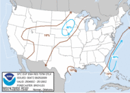
Current Day 2 Outlook

|
Forecaster: CARBIN
Issued: 24/1722Z
Valid: 25/1200Z - 26/1200Z
Forecast Risk of Severe Storms: See Text
|
Current Day 3 Outlook

|
Forecaster: DARROW
Issued: 24/0715Z
Valid: 26/1200Z - 27/1200Z
Forecast Risk of Severe Storms: See Text
Note:The 10% and greater probability thunder line is not included on the Day 3 Outlook.
|
Current Day 4-8 Outlook
|
Forecaster: DARROW
Issued: 24/0830Z
Valid: 27/1200Z - 01/1200Z
Note:A severe weather area
depicted in the Day 4-8 period
indicates a 30% or higher probability for severe thunderstorms
(e.g. a 30% chance that a severe thunderstorm will occur
within 25 miles of any point).
|
| Experimental Enhanced Resolution Thunderstorm Outlooks |
|---|
|
Note:
The Experimental Enhanced Resolution Thunderstorm Outlooks resumed
public access on May 5, 2009.
Please click
here for a description of the revised outlook product.
Please click
here for the Product Description Document (PDD).
We are seeking comments till February 5, 2010.
Please click
here to take the survey.
|
| Retrieving Previous Outlooks |
|---|
|
|
|