|

August 13, 2009 - West Walker River Guidance Changes - The River Guidance (Flood Forecast Point) along the West Walker River at Coleville has been moved to a location upstream on the Highway 395 Bridge Below Little Walker. This plot can be accessed from the map below, our River Guidance webpage, or this quick link. Also, it is advised to change any bookmark that referenced the old location at Coleville.
August 5, 2009 - Santa Clara River Guidance Changes - The River Guidance (Flood Forecast Point) along the Santa Clara River at Freeman Diversion has been moved to a location approximately 7 miles downstream on the Victoria Avenue Bridge. This plot can be accessed from the map below, our River Guidance webpage, or this quick link. Also, it is advised to change any bookmark that referenced the old location at Freeman Diversion.

| Map Type: |
  | Current Zoom Factor: |  | Help: |  | |
 |
|
|
River Guidance
Forecast Status
(Approx 5 Days)
Graphical RVF Search
Gage Information
Place cursor over gage
on map for readout.
|
|
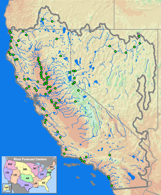
90 Gages Forecast
Normal Conditions
(100.0% of Gages) | 0 Gages Forecast
Above Monitor Stage
(0.0% of Gages) | 0 Gages Forecast
Above Flood Stage
(0.0% of Gages) | 0 Gages Forecast
Above Danger Stage
(0.0% of Gages) | |
Last Map Update: Tuesday August 25th 2009 at 7:10 AM PDT (5 Minutes Old)
(Data is updated every 10 minutes)
|
|
| River Guidance Points Forecast Above Specified Stage Definitions (Select NWSLI for Station Plot) | | NWSLI | River / Creek | Gage / Station | Monitor
Stage | Flood
Stage | Danger
Stage | Max 4Cast
Stage | Max 4Cast
Flow | Forecast
Status |
NO River Guidance Points Currently Forecast Above Specified Stage Definitions. |
** NOTE ** Stage is presented in "Feet" while Flow is presented in "cfs". |
Welcome to the web site of the California Nevada River Forecast Center. The CNRFC is one of 13 National Weather Service River
Forecast Centers in the United States. The CNRFC has hydrologic forecast responsibility for California, most of Nevada, and a portion of southern
Oregon. Our office is colocated with the Sacramento NWS Forecast Office, the California Department of Water Resources, and
the U.S. Bureau of Reclamation.
Our web site serves two purposes:
- Share hydrologic information with our users, including NWS Forecast Offices within our area of responsibility.
- Provide the CNRFC staff with a convenient method to monitor hydrologic and weather conditions.
|
|