Urban Seismic Hazard Mapping
|
The strong ground shaking and resulting catastrophic losses in the 1994 Northridge and the 1995 Kobe, Japan, earthquakes reinforced the need for the USGS to concentrate its efforts where the risks are highest, in the Nation's urban areas. If risks are to be mitigated and plans made for recovery, officials need seismic hazard maps for metropolitan areas at a scale of 1:24,000. The National Seismic Hazard Maps show the potential for damaging earthquakes and the strength of ground shaking on a much broader scale, and do not take into account local and regional geological structures and soil conditions, which may have strong amplifying or damping effects on ground shaking.
Urban seismic hazard mapping activities were initiated by the USGS in 1998, with three projects focussed on high-resolution seismic hazard assessments in at-risk urban areas of the U.S. These assessments reflect local conditions and also address ground failure hazards such as liquefaction and earthquake-triggered landslides. Projects were started in the eastern San Francisco Bay region, Seattle, and Memphis.
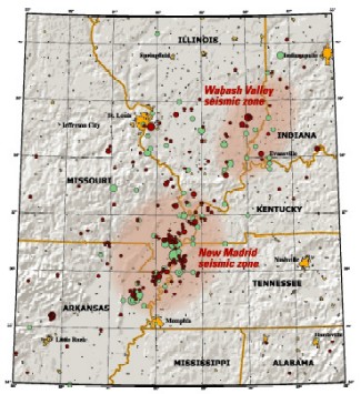
Map of the New Madrid and Wabash Valley seismic zones. Red circles indicate earthquakes that occurred from 1974 to 2002 with magnitudes larger than 2.5 (University of Memphis). Green circles denote earthquakes that occurred prior to 1974 (USGS Professional Paper 1527). Larger earthquakes are represented by larger circles. From USGS Fact Sheet 131-02, " Earthquake Hazard in the Heart of the Homeland" The Memphis project is nearing completion and lessons learned are being applied to new projects developing in the urban areas of St. Louis (Missouri and Illinois) and Evansville (Indiana, Kentucky, and Illinois). In each urban area, publicly available, digital geologic and geotechnical databases are or will be developed and high-resolution seismic hazard maps prepared. The primary focus is on production of probabilistic hazard maps, but the same information also is being used to produce scenario earthquake maps and long term forecasts of earthquake probabilities. All mapping projects are collaborative, with local working groups comprised of members of state geological surveys, the Central U.S. Earthquake Consortium (CUSEC) emergency managers, CUSEC State Geologists, universities, and the Mid-America Earthquake Center. The urban hazard mapping process and its products have the potential to impact future National Seismic Hazard Maps as data and models developed for the urban mapping products will be used in national map updates. While not meant for site-specific applications, the urban hazard maps will provide guidance for those developing and enforcing building codes, setting insurance rates, siting and designing public and private facilities, and developing and implementing emergency response and mitigation plans. They also serve as educational tools, helping to raise the awareness of seismic hazard in the respective communities and throughout the Central and Eastern U.S.. Finally, they focus research so that it serves the public good while advancing our basic scientific understanding, which in turn improves the accuracy of our products. |