| Home >> | Advanced Search >> |
|
|
|
Astronaut Photography of Earth - Display Record
STS106-718-9
Low-resolution Browse Image
(Most browse images are not color adjusted.)Images
Conditions for Use of Images >>Image Transformation Tutorial >> Saving, Color Adjusting, and Printing Images >>
Images to View on Your Computer Now
| File Name | File Size (bytes) | Width | Height | Annotated | Cropped | Purpose | Comments | |
|---|---|---|---|---|---|---|---|---|
| View | STS106-718-9.JPG | 50329 | 515 | 512 | No | No | From ISD PhotoCDs | |
| View | STS106-718-9.JPG | 113957 | 540 | 540 | Yes | Yes | NASA's Earth Observatory web site | |
| View | STS106-718-9.JPG | 1030464 | 2040 | 2045 | NASA's Earth Observatory web site | |||
| View | STS106-718-9_2.JPG | 217294 | 400 | 400 | Yes | Yes | Photographic Highlights |
Large Images to Request for Downloading
| File Name | File Size (bytes) | Width | Height | Annotated | Cropped | Purpose | Comments | |
|---|---|---|---|---|---|---|---|---|
| Request | STS106-718-9.JPG | 155621 | 1031 | 1024 | No | No | From ISD PhotoCDs | |
| Request | STS106-718-9_2.JPG | 446291 | 2063 | 2048 | No | No | From ISD PhotoCDs | |
| Request | STS106-718-9_3.JPG | 1150339 | 4127 | 4096 | No | No | From ISD PhotoCDs | |
| Request | STS106-718-9.TIF | 141475536 | 6840 | 6893 | No | No | Updated image for database | |
| Request | STS106-718-9.JPG | 1030464 | 2040 | 2045 | No | Yes | Photographic Highlights |
Download a Keyhole Markup Language (KML) file for use in Google Earth.
Electronic Image Data
Camera files only apply to electronic still cameras.No sound file available.
Identification
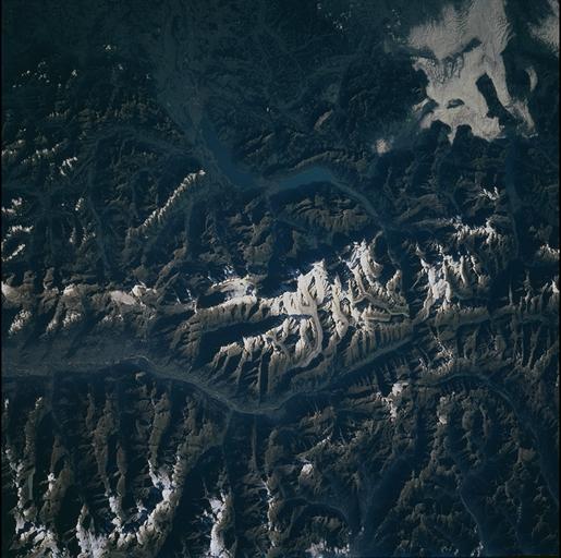
Mission: STS106 Roll: 718 Frame: 9 Mission ID on the Film or image: STS106Country or Geographic Name: SWITZERLAND
Features: BERNESE ALPS, JUNGFRAU PEAK, LAKES
Center Point Latitude: 46.5 Center Point Longitude: 8.0 (Negative numbers indicate south for latitude and west for longitude)
Stereo: (Yes indicates there is an adjacent picture of the same area)
ONC Map ID: JNC Map ID:
Camera
Camera Tilt: 52Camera Focal Length: 250mm
Camera: HB: Hasselblad
Film: 5069 : Kodak Elite 100S, E6 Reversal, Replaces Lumiere, Warmer in tone vs. Lumiere.
Quality
Film Exposure:Percentage of Cloud Cover: 10 (0-10)
Nadir
Date: 20000911 (YYYYMMDD)GMT Time: 074657 (HHMMSS)Nadir Point Latitude: 44.9, Longitude: 4.4 (Negative numbers indicate south for latitude and west for longitude)
Nadir to Photo Center Direction: East
Sun Azimuth: 111 (Clockwise angle in degrees from north to the sun measured at the nadir point)
Spacecraft Altitude: 187 nautical miles (346 km)
Sun Elevation Angle: 25 (Angle in degrees between the horizon and the sun, measured at the nadir point)
Orbit Number: 45
Captions
The Bernese Alps form the centerpiece of this late summer view of Switzerland; Jungfrau (J - 4158 m), Moench (M - 4089 m), and Eiger (E - 3970 m) are among the higher peaks of the Central Alps. North of the range is the city of Interlaken, flanked by the Thune See and Brienzer See (lakes); the long, straight-segmented valley of the Rhone lies to the south.On the southern flank of the Jungfrau massif is the Aletsch glacier, meltwaters of which feed the upper Rhone; another source is the Rhone glacier at the eastern end of the valley. One estimate holds that roughly half the ice in glaciers of the European Alps has melted since 1850. U-shaped valleys carved by glaciers are clearly visible; some, such as that of the Rhone, have been modified by through-flowing rivers.
The Swiss Alps are elements of a great mountain system that was constructed as Africa and Eurasia collided, starting more than 90 million years ago. Ancient basement rocks (>325 million years old) of the Bernese Alps were uplifted, folded, and forced northward between ~29 and 10 million years ago.
Download Packaged File.
This option downloads the following items, packaged into a single file, if they are available:
- Browse image
- Cataloged information with captions
- Camera file
- Sound file
Server: 2 |
This service is provided by the International Space Station program. |
Recommended Citation: |
||

