|
 Home | Image Galleries | Pollutants in the Environment Home | Image Galleries | Pollutants in the Environment
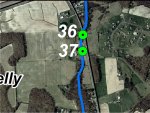
Dogwood Run GPS Location 37
Location 37 is where Maple Springs Farm Road, a single lane road, crosses Dogwood Run. The creek is routed through two 36- to 42-inch corrugated culverts under the road. At the time of the visit, all of the flow was through the central culvert, which is slightly lower than the western culvert. The eastern culvert was high and dry and bent out of shape. The bottom of the central culvert was apparently rusted through and there was sand and gravel under the bridge. The culverts would not restrict fish passage, although the flow was only a few inches deep, which probably precludes use by most fish. There was a rack of sticks and branches lodged against the entrance to the culvert. The riparian zone on both banks for a few hundred yards upstream and downstream of the road crossing is mowed grasses. Beyond the developed areas, the condition of the riparian zone improves. The creek substrate is predominately sandy and there was abundant algae, probably indicating the presence of elevated levels of nutrients in the water.
Click on an image below to see the full image.
|