
 Feeds & Data
Magnitude 6.8 - SANTIAGO DEL ESTERO, ARGENTINA
2006 November 13 01:26:33 UTC
Earthquake Details
| Magnitude | 6.8 |
|---|---|
| Date-Time |
= Coordinated Universal Time = local time at epicenter |
| Location | 26.036°S, 63.244°W |
| Depth | 547 km (339.9 miles) |
| Region | SANTIAGO DEL ESTERO, ARGENTINA |
| Distances | 215 km (135 miles) ENE of San Miguel de Tucuman, Argentina 215 km (135 miles) NNE of Santiago del Estero, Argentina 260 km (160 miles) ESE of Salta, Argentina 1035 km (650 miles) NNW of BUENOS AIRES, Argentina |
| Location Uncertainty | horizontal +/- 7.6 km (4.7 miles); depth +/- 7.6 km (4.7 miles) |
| Parameters | Nst=223, Nph=223, Dmin=688.3 km, Rmss=1.03 sec, Gp= 47°, M-type=teleseismic moment magnitude (Mw), Version=9 |
| Source | USGS NEIC (WDCS-D) |
| Event ID | usvaad |
- This event has been reviewed by a seismologist.
Did you feel it?
Report shaking and damage at your location. You can also view a map displaying accumulated data from your report and others.
Earthquake Summary


Felt Reports
Felt (III) in Catamarca, Corrientes, La Rioja and San Juan. Also felt at Asuncion, Paraguay.
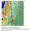
Earthquake Maps
Earthquake Location
Location Maps

Did You Feel It?
Tell Us

ShakeMap
Historical Seismicity

Seismic Hazard Map

EQ Density Map

Google Map

 Historic Moment Tensor Solutions
- Preliminary Earthquake Report
- U.S. Geological Survey, National Earthquake Information Center
World Data Center for Seismology, Denver
