
 Feeds & Data
Magnitude 6.3 - NORTHERN QINGHAI, CHINA
2008 November 10 01:22:02 UTC
Earthquake Details
| Magnitude | 6.3 |
|---|---|
| Date-Time |
|
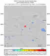
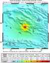
| Location | 37.589°N, 95.836°E |
| Depth | 19 km (11.8 miles) set by location program |
| Region | NORTHERN QINGHAI, CHINA |
| Distances | 55 km (35 miles) ESE of Da Qaidam, Qinghai, China 155 km (95 miles) NNE of Golmud, Qinghai, China 1800 km (1120 miles) W of BEIJING, Beijing, China |
| Location Uncertainty | horizontal +/- 3.5 km (2.2 miles); depth fixed by location program |
| Parameters | NST=257, Nph=257, Dmin=977.7 km, Rmss=0.89 sec, Gp= 11°, M-type=regional moment magnitude (Mw), Version=S |
| Source |
|
| Event ID | us2008zfae |
- This event has been reviewed by a seismologist.
- Did you feel it? Report shaking and damage at your location. You can also view a map displaying accumulated data from your report and others.
Earthquake Summary


Felt Reports
Three people injured, several buildings damaged and utility lines disrupted at the Dameigou Coal Mine. Damage at the mine was estimated at 4 million US dollars. Several homes collapsed at Golmud. About 20 homes damaged and utilities disrupted at Da Qaidam.
Earthquake Maps


Scientific & Technical Information

- Preliminary Earthquake Report
- U.S. Geological Survey, National Earthquake Information Center:
World Data Center for Seismology, Denver
