My
List |
Catalog #
|
Target
|
Mission
|
Instrument
|
Addition Date
|
Size
|

|
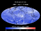
PIA12133 |
Earth |
Gravity Recovery and Climate Experiment (GRACE)
|
K-Band Ranging System
|
2009-07-15 |
1200x1200x3 |

|
- Title:
- Global Gravity: Asia and Australia
|
|
|
PIA11186 |
Earth |
Earth Observing System (EOS)
|
Atmospheric Infrared Sounder (AIRS)
|
2008-09-22 |
1777x948x3 |
|
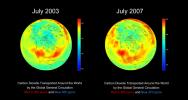
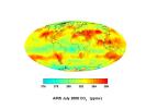
- Title:
- AIRS Global Distribution of Mid-Tropospheric Carbon Dioxide at 18-13 km
Altitudes
|
|
|
PIA12132 |
Earth |
Gravity Recovery and Climate Experiment (GRACE)
|
K-Band Ranging System
|
2009-07-15 |
1200x1200x3 |

|
- Title:
- Global Gravity: North and South America
|
|
|
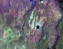
PIA12093 |
Earth |
Earth Observing System (EOS)
|
ASTER
|
2009-06-29 |
1280x720x3 |

|
- Title:
- Los Angeles Basin
|
|
|
PIA10631 |
Earth |
Earth Observing System (EOS)
|
ASTER
|
2008-04-30 |
900x720x3 |

|
- Title:
- Diomede Islands, Bering Straight
|
|
|
PIA12158 |
Moon |
Chandrayaan-1
|
Moon Mineralogy Mapper
|
2009-08-03 |
1709x669x3 |

|
- Title:
- Moon Mapper Looks Homeward
|
|
|
PIA12058 |
Earth |
Earth Observing System (EOS)
|
ASTER
|
2009-03-16 |
2676x1918x3 |

|
- Title:
- Karymsky Volcano, Kamchatka
|
|
|
PIA11085 |
Earth |
Earth Observing System (EOS)
|
ASTER
|
2008-08-28 |
3832x2956x3 |

|
- Title:
- Colorado River Delta
|
|
|
PIA12009 |
Moon |
Gravity Recovery and Interior Laboratory (GRAIL)
|
|
2009-05-18 |
6000x4000x3 |

|
- Title:
- GRAIL's Twin Spacecraft fly in Tandem Around the Moon (Artist's Concept)
|
|
|
PIA12091 |
Earth |
Earth Observing System (EOS)
|
ASTER
|
2009-06-29 |
1488x1493x3 |

|
- Title:
- Death Valley, California
|
|
|
PIA12064 |
Earth |
Earth Observing System (EOS)
|
ASTER
|
2009-06-02 |
2282x1772x3 |

|
- Title:
- Jack Hills, Australia
|
|
|
PIA11032 |
Earth |
Earth Observing System (EOS)
|
Atmospheric Infrared Sounder (AIRS)
|
2008-08-13 |
321x239x3 |

|
- Title:
- Hurricane Isabel Isotherms

|
|
|
PIA11066 |
Earth |
ISS EarthKam
|
Electronic Still Camera
|
2008-09-05 |
3060x2036x3 |

|
- Title:
- Oblique shot of Earth
|
|
|
PIA11394 |
Earth |
Earth Observing System (EOS)
|
ASTER
|
2008-11-03 |
6630x5000x3 |

|
- Title:
- Aftermath of Hurricane Ike along Texas Coast
|
|
|
PIA11989 |
Earth |
Earth Observing System (EOS)
|
ASTER
|
2009-04-19 |
2508x5460x3 |
|
- Title:
- North Dakota Floods
|
|
|
PIA11067 |
Earth |
ISS EarthKam
|
Electronic Still Camera
|
2008-09-05 |
3060x2036x3 |
|
- Title:
- Alluvial fan in China
|
|
|
PIA11015 |
Earth |
ISS EarthKam
|
Electronic Still Camera
|
2008-09-04 |
3060x2036x3 |
|
- Title:
- Algeria
|
|
|
PIA11034 |
Earth |
Earth Observing System (EOS)
|
Atmospheric Infrared Sounder (AIRS)
|
2008-08-14 |
640x480x3 |
|
- Title:
- Transport of Carbon Monoxide Generated by Alaska Fires, July 2004
|
|
|
PIA11997 |
Earth |
Jason-1 (TOPEX/Poseidon)
OSTM/Jason-2
|
Altimeter
|
2009-04-27 |
1010x654x3 |
|
- Title:
- OSTM/Jason-2 and Jason-1 Tandem Mission View of the Gulf Stream
|
|
|
PIA11806 |
Earth |
Earth Observing System (EOS)
|
ASTER
|
2009-02-18 |
3315x3324x3 |

|
- Title:
- Australia Wildfires Extract a Heavy Toll in Lives, Land
|
|
|
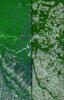
PIA11065 |
Earth |
ISS EarthKam
|
Electronic Still Camera
|
2008-09-05 |
3060x2036x3 |

|
- Title:
- Delta of the Gurupi, Maracacume, and Tiriacu Rivers, Brazil
|
|
|
PIA11169 |
Earth |
Earth Observing System (EOS)
|
ASTER
|
2008-09-16 |
3190x2810x3 |

|
- Title:
- Northern Greenland
|
|
|
PIA11424 |
Earth |
Earth Observing System (EOS)
|
Atmospheric Infrared Sounder (AIRS)
|
2008-11-18 |
1024x576x3 |

|
- Title:
- Water Vapor Transport, June through November 2005 (Movie)
|
|
|
PIA10925 |
Earth |
Earth Observing System (EOS)
|
ASTER
|
2008-06-30 |
3858x2484x3 |

|
- Title:
- Fires Burning near Big Sur, California
|
|
|
PIA11082 |
Earth |
Earth Observing System (EOS)
|
ASTER
|
2008-06-18 |
2706x2134x3 |
|
- Title:
- East African Rift
|
|
|
PIA11014 |
Earth |
ISS EarthKam
|
Electronic Still Camera
|
2008-09-04 |
3060x2036x3 |

|
- Title:
- North Island, New Zealand
|
|
|
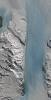
PIA11991 |
Earth |
Earth Observing System (EOS)
|
ASTER
|
2009-04-20 |
3235x2351x3 |

|
- Title:
- Wilkins Ice Shelf
|
|
|
PIA11395 |
Earth |
Earth Observing System (EOS)
|
Atmospheric Infrared Sounder (AIRS)
|
2008-11-03 |
3840x2160x3 |

|
- Title:
- AIRS Carbon Dioxide with Mauna Loa Carbon Dioxide Overlaid
|
|
|
PIA11171 |
Earth |
Earth Observing System (EOS)
|
Atmospheric Infrared Sounder (AIRS)
|
2008-09-17 |
638x478x3 |

|
- Title:
- AIRS Collects Data and Creates a Temperature Profile
|
|
|
PIA10365 |
Earth |
Earth Observing System (EOS)
|
ASTER
|
2008-04-04 |
393x416x3 |
|
- Title:
- Hawaii's Kilauea Volcano Belches a Toxic Brew
|
|
|
PIA11083 |
Earth |
Earth Observing System (EOS)
|
ASTER
|
2008-07-18 |
1639x1611x3 |

|
- Title:
- L'Anse Aux Meadows, Newfoundland
|
|
|
PIA11019 |
Earth |
ISS EarthKam
|
Electronic Still Camera
|
2008-09-04 |
3060x2036x3 |
|
- Title:
- Tongue of the Ocean and Grand Bahama Bank
|
|
|
PIA11068 |
Earth |
ISS EarthKam
|
Electronic Still Camera
|
2008-09-05 |
3060x2036x3 |

|
- Title:
- Atlantic (maybe Caribbean Sea) Ocean and Islands
|
|
|
PIA10626 |
Earth |
Earth Observing System (EOS)
|
ASTER
|
2008-03-10 |
1596x1509x3 |

|
- Title:
- Longyearbyen, Svalbard, Norway
|
|
|
PIA10628 |
Earth |
Earth Observing System (EOS)
|
ASTER
|
2008-04-01 |
2536x2104x3 |
|
- Title:
- Western Slope of Andes, Peru
|
|
|
PIA10975 |
Earth |
Earth Observing System (EOS)
|
ASTER
|
2008-07-23 |
1503x2214x3 |

|
- Title:
- Yolla Bolly Complex Wildland Fire
|
|
|
PIA11752 |
Earth |
Earth Observing System (EOS)
|
ASTER
|
2009-01-09 |
3136x1656x3 |

|
- Title:
- Bodele Sand Dunes, Chad
|
|
|
PIA10927 |
Earth |
Earth Observing System (EOS)
|
Multi-angle Imaging SpectroRadiometer (MISR)
|
2008-07-02 |
1267x1187x3 |

|
- Title:
- Smoke Blankets Northern California
|
|
|
PIA10377 |
Earth |
Jason-1 (TOPEX/Poseidon)
|
Altimeter
|
2008-04-22 |
900x900x3 |

|
- Title:
- Larger Pacific Climate Event Helps Current La Niña Linger
|
|
|
PIA10772 |
Earth |
Earth Observing System (EOS)
|
ASTER
|
2008-06-06 |
1761x1054x3 |

|
- Title:
- Sichuan Earthquake in China
|
|
|
PIA12097 |
Earth |
Earth Observing System (EOS)
|
Atmospheric Infrared Sounder (AIRS)
|
2009-06-30 |
1600x1025x3 |

|
- Title:
- Global Total Precipitable Water Wapor for May 2009
|
|
|
PIA11033 |
Earth |
Earth Observing System (EOS)
|
Atmospheric Infrared Sounder (AIRS)
|
2008-08-13 |
319x240x3 |

|
- Title:
- Supertyphoon Pongsona Isotherms
|
|
|
PIA12092 |
Earth |
Earth Observing System (EOS)
|
ASTER
|
2009-06-29 |
1556x1370x3 |

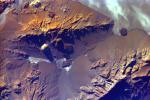
|
- Title:
- Himalayan Glaciers in Bhutan
|
|
|
PIA11016 |
Earth |
ISS EarthKam
|
Electronic Still Camera
|
2008-09-04 |
3060x2036x3 |
|
- Title:
- South Australia, Australia
|
|
|
PIA12055 |
Earth |
Earth Observing System (EOS)
|
ASTER
|
2009-02-09 |
2468x1992x3 |

|
- Title:
- Jamestown, VA
|
|
|
PIA11018 |
Earth |
ISS EarthKam
|
Electronic Still Camera
|
2008-09-04 |
3060x2036x3 |

|
- Title:
- Sakhalin Island, Russia
|
|
|
PIA11020 |
Earth |
ISS EarthKam
|
Electronic Still Camera
|
2008-09-04 |
3060x2036x3 |

|
- Title:
- Isla Isabella, Galapagos Island
|
|
|
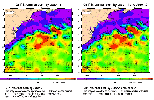
PIA10954 |
Earth |
OSTM/Jason-2
|
Advanced Microwave Radiometer (AMR)
|
2008-07-15 |
2400x2772x3 |
|
- Title:
- Global Views of Atmospheric Water Vapor:
First Data from OSTM/Jason-2's Advanced Microwave Radiometer
|
|
|
PIA11081 |
Earth |
Earth Observing System (EOS)
|
ASTER
|
2008-05-30 |
800x295x3 |

|
- Title:
- Chaiten Volcano, Chile
|
|
|
PIA12010 |
Moon |
Gravity Recovery and Interior Laboratory (GRAIL)
|
|
2009-05-18 |
8000x7500x3 |

|
- Title:
- GRAIL's Twin Spacecraft -- Crust to Core (Artist's Concept)
|
|
|
PIA12062 |
Earth |
Earth Observing System (EOS)
|
ASTER
|
2009-05-01 |
1446x803x3 |

|
- Title:
- Banks Peninsula, New Zealand
|
|
|
PIA11017 |
Earth |
ISS EarthKam
|
Electronic Still Camera
|
2008-09-04 |
3060x2036x3 |
|
- Title:
- Aracar Volcano, Andes Mountains, Argentina near Chile Border
|
|
|
PIA10241 |
Earth |
Earth Observing System (EOS)
|
Atmospheric Infrared Sounder (AIRS)
|
2008-03-12 |
4196x2747x3 |

|
- Title:
- AIRS Mean Carbon Monoxide at 500 Millibar, September 22-29, 2002
|
|
|
PIA11194 |
Earth |
Earth Observing System (EOS)
|
Atmospheric Infrared Sounder (AIRS)
|
2008-09-24 |
5000x3750x3 |
|
- Title:
- Global Carbon Dioxide Transport from AIRS Data, July 2008
|
|
|
PIA11420 |
Earth |
Earth Observing System (EOS)
|
ASTER
|
2008-10-16 |
1922x2982x3 |
|
- Title:
- Mato Grosso, Brazil
|
|
|
PIA10242 |
Earth |
Earth Observing System (EOS)
|
Atmospheric Infrared Sounder (AIRS)
|
2008-03-17 |
1428x1836x3 |

|
- Title:
- Mean Clear Air Precipitable Water, 500mb to TOA from AIRS data
|
|
|
PIA11084 |
Earth |
Earth Observing System (EOS)
|
ASTER
|
2008-08-08 |
3656x4124x3 |

|
- Title:
- Rub' al Khali, Arabia
|
|
|
PIA12094 |
Earth |
Earth Observing System (EOS)
|
ASTER
|
2009-06-29 |
1281x718x3 |

|
- Title:
- Cruising Over California
|
|
|
PIA11086 |
Earth |
QuikScat
|
SeaWinds Scatterometer
|
2008-09-11 |
2344x926x3 |

|
- Title:
- Recent State of Arctic Sea Ice
|
|
|
PIA11794 |
Earth |
Jason-1 (TOPEX/Poseidon)
OSTM/Jason-2
|
Altimeter
|
2009-02-06 |
1074x1074x3 |

|
- Title:
- Altimeter Family Portrait: Topex/Poseidon, Jason-1 and OSTM/Jason-2
|
|
|
PIA12057 |
Earth |
Earth Observing System (EOS)
|
ASTER
|
2009-03-02 |
2368x3020x3 |

|
- Title:
- Palm Islands, Dubai, UAE
|
|
|
PIA10953 |
Earth |
|
|
2008-07-06 |
1148x1119x3 |

|
- Title:
- 70m antenna at Goldstone, California
|
|
|
PIA11419 |
Earth |
Earth Observing System (EOS)
|
ASTER
|
2008-11-17 |
4070x8024x3 |
|
- Title:
- Byrd Glacier, Antarctica
|
|
|
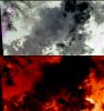
PIA12075 |
Earth |
UAVSAR
|
L-Band UAVSAR
|
2009-06-18 |
2984x2737x3 |

|
- Title:
- Scientists Search for a Pulse in Skies Above Earthquake Country
|
|
|
PIA11061 |
Earth |
ISS EarthKam
|
Electronic Still Camera
|
2008-09-05 |
3060x2036x3 |

|
- Title:
- Frozen Lake Quinghai Nanshan, Northern China
|
|
|
PIA12146 |
Earth |
Gravity Recovery and Climate Experiment (GRACE)
|
K-Band Ranging System
|
2009-07-17 |
455x455x3 |

|
- Title:
- GRACE Global Gravity Animation
|
|
|
PIA12077 |
Moon |
Deep Space Network (DSN)
|
Goldstone Solar System Radar
|
2009-06-18 |
4000x3796x3 |

|
- Title:
- Moon's Rugged South Polar Region Composite
|
|
|
PIA11021 |
Earth |
ISS EarthKam
|
Electronic Still Camera
|
2008-09-04 |
3060x2036x3 |

|
- Title:
- The Persian Gulf and the Delta of the Tigris and Euphrates Rivers, Kuwait, Iraq, and Iran
|
|
|
PIA11207 |
Earth |
Phoenix
|
|
2008-09-30 |
1228x910x1 |

|
- Title:
- Terrestrial Clay under Microscope
|
|
|
PIA12095 |
Earth |
Earth Observing System (EOS)
|
ASTER
|
2009-06-29 |
1280x720x3 |

|
- Title:
- Cruising Over Los Angeles
|
|
|
PIA10244 |
Earth |
Mars Reconnaissance Orbiter (MRO)
|
HiRISE
|
2008-03-03 |
800x800x3 |

|
- Title:
- Earth and Moon as Seen from Mars
|
|
|
PIA12060 |
Earth |
Earth Observing System (EOS)
|
ASTER
|
2009-04-03 |
3108x4319x3 |

|
- Title:
- Musandam Penisnula, Oman
|
|
|
PIA11807 |
Earth |
Earth Observing System (EOS)
|
Atmospheric Infrared Sounder (AIRS)
|
2009-02-19 |
764x522x3 |

|
- Title:
- Carbon Monoxide from the Australian Fires of Feb 2009 as seen by AIRS
|
|
|
PIA12059 |
Earth |
Earth Observing System (EOS)
|
ASTER
|
2009-03-26 |
1949x2646x3 |

|
- Title:
- Grand Turk Island
|