
Click on image for larger annotated version
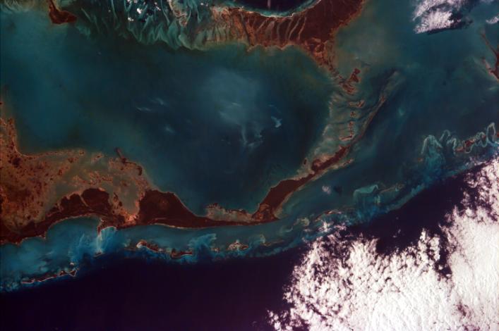
This image captures the tropical beauty of the major islands of the Little
Bahama Bank, the most northerly of the island groups that comprise the
Bahamas. The island at the west edge of the image is Grand Bahama Island,
which lies 60 miles east of West Palm Beach in Florida and boasts the
second largest city in the Bahamas, Freeport. The island takes up an area
of 530 square miles and has a population of 40,898 (1990). The economy is,
of course, based on tourism and fishing, with a substantial amount of
forest products adding to economic exports. The islands taking up the
center and southeast edge of the image are Little Abaco and Great Abaco.
The Abaco island group takes up 780 square miles, and is the most
northerly section of the Bahamas. Most of the water visible in this image
is relatively shallow, reaching depths of no more than 200m (650ft). Along
the northeastern edge of the photo, however, there is a visible drop off
as the depth increases from 200m (650ft) along the Little Bahama Bank to
1000m (3281 ft) in the open Atlantic Ocean.
The islands of the Bahamas rest on a foundation of ancient coral, on top
of which is a layer of sandy soil. Towards the interior of the islands,
this soil is cemented to form Bahama limestone. Because they are built up
merely by sedimentation and coral growth, the landscape is quite flat and
only about 20 feet above sea level on average.
This image was taken from the Space Shuttle on January 20, 1997. Image,
geographic, and position and camera information can be viewed on the
ISS EarthKAM meta data page.
Photojournal note:
EarthKAM was formerly known as KidSat. To see images of KidSat, see
http://photojournal.jpl.nasa.gov/mission/KidSat .
