
 Feeds & Data
Magnitude 5.6 - MINDANAO, PHILIPPINES
2009 August 12 20:04:25 UTC
Earthquake Details
| Magnitude | 5.6 |
|---|---|
| Date-Time |
|
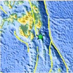
| Location | 6.046°N, 126.356°E |
| Depth | 95 km (59.0 miles) set by location program |
| Region | MINDANAO, PHILIPPINES |
| Distances | 130 km (80 miles) E of General Santos, Mindanao, Philippines 140 km (85 miles) SE of Davao, Mindanao, Philippines 255 km (155 miles) S of Hinatuan, Mindanao, Philippines 1110 km (690 miles) SSE of MANILA, Philippines |
| Location Uncertainty | horizontal +/- 6.1 km (3.8 miles); depth fixed by location program |
| Parameters | NST=105, Nph=105, Dmin=142.2 km, Rmss=0.93 sec, Gp= 40°, M-type=teleseismic moment magnitude (Mw), Version=7 |
| Source |
|
| Event ID | us2009kfb7 |
- This event has been reviewed by a seismologist.
- Did you feel it? Report shaking and damage at your location. You can also view a map displaying accumulated data from your report and others.

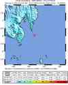
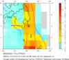
Earthquake Maps


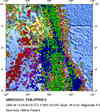


Scientific & Technical Information

- Preliminary Earthquake Report
- U.S. Geological Survey, National Earthquake Information Center:
World Data Center for Seismology, Denver
