
 Feeds & Data
Magnitude 5.5 - SOUTH SANDWICH ISLANDS REGION
2009 August 12 14:50:16 UTC
Earthquake Details
| Magnitude | 5.5 |
|---|---|
| Date-Time |
|
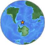
| Location | 57.681°S, 25.331°W |
| Depth | 53.4 km (33.2 miles) |
| Region | SOUTH SANDWICH ISLANDS REGION |
| Distances | 160 km (100 miles) SE of Visokoi Island, South Sandwich Islands 160 km (100 miles) NNE of Bristol Island, South Sandwich Islands 3570 km (2220 miles) SSE of BUENOS AIRES, Argentina |
| Location Uncertainty | horizontal +/- 11.3 km (7.0 miles); depth +/- 32.1 km (19.9 miles) |
| Parameters | NST= 31, Nph= 31, Dmin=>999 km, Rmss=0.81 sec, Gp= 83°, M-type=body wave magnitude (Mb), Version=7 |
| Source |
|
| Event ID | us2009kfa9 |
- This event has been reviewed by a seismologist.
- Did you feel it? Report shaking and damage at your location. You can also view a map displaying accumulated data from your report and others.
Earthquake Maps


Scientific & Technical Information

- Preliminary Earthquake Report
- U.S. Geological Survey, National Earthquake Information Center:
World Data Center for Seismology, Denver
