
 Feeds & Data
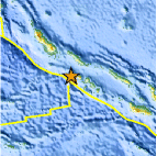
Magnitude 5.4 - SOLOMON ISLANDS
2009 August 07 20:28:49 UTC
Earthquake Details
| Magnitude | 5.4 |
|---|---|
| Date-Time |
|
| Location | 7.949°S, 156.533°E |
| Depth | 10 km (6.2 miles) set by location program |
| Region | SOLOMON ISLANDS |
| Distances | 40 km (25 miles) WNW of Gizo, New Georgia Islands, Solomon Isl. 140 km (90 miles) S of Chirovanga, Choiseul, Solomon Islands 410 km (255 miles) WNW of HONIARA, Guadalcanal, Solomon Islands 2190 km (1360 miles) N of BRISBANE, Queensland, Australia |
| Location Uncertainty | horizontal +/- 9 km (5.6 miles); depth fixed by location program |
| Parameters | NST= 89, Nph= 89, Dmin=410 km, Rmss=1.28 sec, Gp= 40°, M-type=body wave magnitude (Mb), Version=7 |
| Source |
|
| Event ID | us2009kabz |
- This event has been reviewed by a seismologist.
- Did you feel it? Report shaking and damage at your location. You can also view a map displaying accumulated data from your report and others.
Earthquake Summary

 Tsunami Information
- NOAA West Coast & Alaska Tsunami Warning Center
- NOAA Pacific Tsunami Warning Center
- Tsunami Information Links
The earthquake locations and magnitudes cited in these NOAA tsunami bulletins are very preliminary and may be superceded by USGS locations and magnitudes computed using more extensive data sets.
Earthquake Maps


Scientific & Technical Information
 Historic Moment Tensor Solutions
- Preliminary Earthquake Report
- U.S. Geological Survey, National Earthquake Information Center:
World Data Center for Seismology, Denver
