- Home
- About S&T
- Taxa/Organisms
- Ecosystems
- Issues
- Methods & Tools
- Reports & Publications
- Location
- Search
Publisher: USGS | Science Center: Fort Collins Science Center (FORT, Ft. Collins) | Format: URL
www.fort.usgs.gov — This publication is intended to provide a summary of long-range surveillance radar technology and applications of these data to questions about movement patterns of birds and other flying wildlife based on publications that provide more detailed information (Buurma, 1995; Gauthreaux and Belser, 2003a, b; Gauthreaux and others, 2003; Diehl and More...
Publisher: USGS | Format: URL
pubs.usgs.gov — This web resource describes the U.S. Geological Survey (USGS) Across Trophic Level System Simulation (ATLSS) Program, which has produced a set of models, including spatially explicit species index models, population demography models, and ecosystem process models that are designed to evaluate the ecological effects of hydrologic scenarios on More...

Publisher: USGS (Coastal and Marine Geology Program) | Format: URL
terraweb.wr.usgs.gov — This website is the Terrestrial Remote Sensing Software and Research Web Server. Featured on this site are image products and information generated using remote sensing in various Earth environments. Digital satellite, sonar, bathymetry, elevation, aerial, and ground photography image products for practical applications, such as resource More...
Publisher: USGS | Format: URL
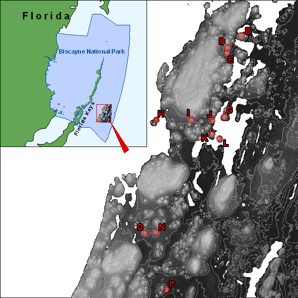
pubs.usgs.gov — This web resource is a map that shows all of the biological communities and geomorphology of patch reefs in Biscayne National Park, Florida. The map shows all of the patch reefs in Biscayne National Park that were surveyed in September 2003. Scientists investigated the relationships among physical, benthic, and fish variables in effort to help More...