


ARM Enhanced Shortwave Experiment (ARESE)
September 25 - November 1, 1995
Overview
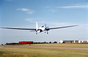
ARESE studied the absorption of solar radiation by the clear and cloudy atmosphere. Measurements were conducted using three aircraft platforms: a high altitude manned Egrett aircraft, an instrumented Twin Otter and the NASA ER-2, as well as satellites and the ARM central and extended facilities in North Central Oklahoma. The project ran from September 22 - November 1, 1995.
Further Information
NCAR MAPR ISS Experiment
Steve Cohn at NCAR has deployed the NCAR Advanced Integrated Sounding System (ISS) at a location 2 miles west of Braman, Oklahoma, (exit 230 off of I-35, which is about 20 miles northeast of the Central Facility ) in support of their MAPR-Spaced Antenna ISS experiment, for the period September 11-25, 1995. This is part of their Science Team project. During this time, 25 CLASS radiosondes will be launched. NCAR is operating totally independent of ARM, but is located within the SGP CART domain.
Their objectives are address instrument and technique development and validation of the ISS with the goal of momentum and heat flux profiling. Also, high temporal observations of the nocturnal, low-level jet are being attempted.
Although not an ARESE participant, their field work does overlap ARESE. For that reason, it is reported here. Data may be available upon request. Rick Cederwall is the DSIT representative.
Information on data products derived from satellite data (from Minnis at Langley)
Pat Minnis' group at NASA Langley will be producing data products for ARESE from the satellite data. These products include cloud properties and top-of-the-atmosphere albedo along the flight tracks and over each of the surface sites. They will make these datasets available approximately 30 days after they obtain flight track info from the ARESE science team.
In addition, they will have an initial ARM-satellite cloud/radiation data product out for ARESE in mid-December. That data set will be the same as the Oct 94 data except for the ARESE time period (Sep-Nov 95). It will be available on the Langley ARM page.
Space and internet connections at the Blackwell/Tonkawa airport for ARESE
- Tim Tooman has confirmed that there will be space in a Scientific Trailer at the Airport. There will be 5 tables in the trailer with planned seating for 6-7 people. Five of these have been reserved for Pat Minnis (2), Jay Mace (2) and Bill Collins (assuming a workstation can be found and funding is adequate).
- Space on the tables should be adequate for the four definite workstations (Minnis 2, Mace 2) and the possible 5th (Collins), provided a suitable machine can be found.
- There will be an Internet line into the Trailer and John Nash believes the anticipated traffic should not interfere with the UAV use of the T1 line. If there is interference, UAV traffic will have to be given priority.
- Please contact John Nash at JCNASH@saix367.sandia.gov to confirm that your machines will have the correct hardware to connect into the Internet in the trailer.
- The first UAV flight is planned for Friday 22 Sept. Therefore, to have your equipment in place and a chance to iron out any bugs please arrive there earlier in the week, as it is likely that the UAV people who could help you with space or hardware problems will be fully occupied with UAV activities for the two days before the flight. The UAV group will arrive at the airport on the 12th.
Contacts
Francisco Valero, ARESE Chief Scientist
John Vitko, ARESE Campaign Coordinator
Doug Sisterson, ARM SGP Site Manager
Tim Tooman, UAV Coordinator
DSIT Contacts ARM Data and Science Integration Team (DSIT) Contact