
 Feeds & Data
Magnitude 7.6 - OFF WEST COAST OF THE SOUTH ISLAND, N.Z.
2009 July 15 09:22:29 UTC
Earthquake Details
| Magnitude | 7.6 |
|---|---|
| Date-Time |
|
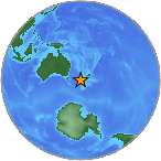
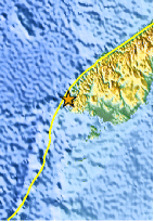
| Location | 45.750°S, 166.577°E |
| Depth | 12 km (7.5 miles) set by location program |
| Region | OFF WEST COAST OF THE SOUTH ISLAND, N.Z. |
| Distances | 155 km (95 miles) WNW of Invercargill, New Zealand 185 km (115 miles) WSW of Queenstown, New Zealand 305 km (190 miles) W of Dunedin, New Zealand 825 km (520 miles) SW of WELLINGTON, New Zealand |
| Location Uncertainty | Error estimate not available |
| Parameters | NST=209, Nph=209, Dmin=328.5 km, Rmss=0 sec, Gp= 25°, M-type=teleseismic moment magnitude (Mw), Version=9 |
| Source |
|
| Event ID | us2009jcap |
- This event has been reviewed by a seismologist.
- Did you feel it? Report shaking and damage at your location. You can also view a map displaying accumulated data from your report and others.
Earthquake Summary
Tectonic Summary
The North and South Islands of New Zealand straddle the boundary between the Australian and Pacific plates. Along this boundary through southern New Zealand, the Australian Plate moves to the northeast at a rate of 35-45 mm/yr relative to the Pacific plate. In Southwestern South Island, this motion is accommodated by oblique convergence at the Puysegur Trench, where the Australian Plate subducts beneath the Pacific Plate. Further north along the South Islands’ west coast, relative motion is accommodated via oblique strike-slip movement along the Alpine Fault, driving the uplift of the Southern Alps.
The recent (09/07/15) thrust earthquake occurred near the southern tip of South Island in a region known as Fiordland, in a complex area of transition in plate boundary structure from Puysegur subduction to Alpine fault strike-slip motion. The preliminary location, depth, and estimate of fault orientation of this event are consistent with the earthquake having resulted from slip on the subduction thrust interface between the Pacific and Australian plates. The deformed Australian plate beneath Fiordland is highly active both along its’ interface with the Pacific plate and internal to the subducted Australian plate. Over the past two decades, several large earthquakes have occurred in Fiordland, predominantly in a cluster to the northeast of today’s earthquake. Though the faulting mechanisms of those events are similar to today’s earthquake, their slip vectors are rotated clockwise with respect to plate motions, and thus may not represent exactly the same style of faulting.

The most recent of these previous large events occurred in August of 2003 when a magnitude 7.2 earthquake approximately 100 km to the northwest caused minor damage in Otago and Southland, and numerous landslides across the Fiordland region. A magnitude 7.0 event on August 10, 1993 caused power outages in the Te Anau area and was felt throughout South Island and as far away as Sydney, Australia. A magnitude 6.4 earthquake struck on May 31, 1989 and was felt strongly in the southwestern part of South Island and a magnitude 6.7 quake struck on June 3, 1988.
PDF
Earthquake Information for New Zealand
 Tsunami Information
- NOAA West Coast & Alaska Tsunami Warning Center
- NOAA Pacific Tsunami Warning Center
- Tsunami Information Links
The earthquake locations and magnitudes cited in these NOAA tsunami bulletins are very preliminary and may be superceded by USGS locations and magnitudes computed using more extensive data sets.
Earthquake Maps


Scientific & Technical Information

Additional Information, News Reports
- Preliminary Earthquake Report
- U.S. Geological Survey, National Earthquake Information Center:
World Data Center for Seismology, Denver
