|
 07/06/07
Western ground water and climate change--Pivotal to
supply sustainability or vulnerable in its own right?
Release:
Epic droughts of the last 2000 years: USGS science on climate change.
Release:
Key challenges for science identified by the USGS to support western water
management.
Release:
USGS scientists document widespread increases in streamflow and changes in
timing of snowmelt over the past 50 years.
USGS Drought, Climate Variability, and Water Supply
Workshop.
USGS Fact Sheet:
Climatic Fluctuations, Drought, and Flow in the Colorado River.
USGS Research Links Long-Term Droughts in U.S. to
Ocean Temperature Variations.
Table ||
Map of current
conditions in Wyoming.
Annual Water Data Report for water year 2006 published. Go
here for a
brief introduction and link to the product.
Wyoming 2006 final streamflow data
online.
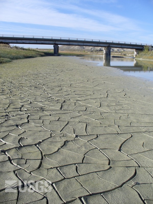
Blacks Fork nr Little America
Sep 19, 2007 10.7 ft3/sec (mean = 70).
(J. Wheeler, USGS)
More
photographs.
News
release: USGS research in anticipating megadroughts.
Statement
by Robert Hirsch, USGS Associate Director for Water, delivered at the 2002 Drought
Summit.
Year 2004 press releases for May || June || August monthly
streamflows.
Year 2003 press release for retrospective of water year 2002.
Year 2002 press releases for April || May || June || July || September monthly
streamflows.
Year 2001 press releases for April || May || June || July || August monthly
streamflows.
Year 2000 press releases for May || June || July || August || September
monthly streamflows and ground-water
levels in a southeast Wyoming well.
National Integrated Drought Information System NIDIS
Updated 12/08/07
Wyoming State Climate Office drought
monitor
Updated 07/06/07
Precipitation
required to end or ameliorate the current drought and the
probabilities of that occurring.
Climate Prediction Center climate
outlook
U.S. Drought Monitor map and summary
NOAA's Drought Information
Center
NRCS SNOTEL data, graphs,
and precipitation
|| water
content maps
National Weather Service
07/06/07
Western ground water and climate change--Pivotal to
supply sustainability or vulnerable in its own right?
Release:
Epic droughts of the last 2000 years: USGS science on climate change.
Release:
Key challenges for science identified by the USGS to support western water
management.
Release:
USGS scientists document widespread increases in streamflow and changes in
timing of snowmelt over the past 50 years.
USGS Drought, Climate Variability, and Water Supply
Workshop.
USGS Fact Sheet:
Climatic Fluctuations, Drought, and Flow in the Colorado River.
USGS Research Links Long-Term Droughts in U.S. to
Ocean Temperature Variations.
Table ||
Map of current
conditions in Wyoming.
Annual Water Data Report for water year 2006 published. Go
here for a
brief introduction and link to the product.
Wyoming 2006 final streamflow data
online.
Blacks Fork nr Little America
Sep 19, 2007 10.7 ft3/sec (mean = 70).
(J. Wheeler, USGS)
More
photographs.
News
release: USGS research in anticipating megadroughts.
Statement
by Robert Hirsch, USGS Associate Director for Water, delivered at the 2002 Drought
Summit.
Year 2004 press releases for May || June || August monthly
streamflows.
Year 2003 press release for retrospective of water year 2002.
Year 2002 press releases for April || May || June || July || September monthly
streamflows.
Year 2001 press releases for April || May || June || July || August monthly
streamflows.
Year 2000 press releases for May || June || July || August || September
monthly streamflows and ground-water
levels in a southeast Wyoming well.
National Integrated Drought Information System NIDIS
Updated 12/08/07
Wyoming State Climate Office drought
monitor
Updated 07/06/07
Precipitation
required to end or ameliorate the current drought and the
probabilities of that occurring.
Climate Prediction Center climate
outlook
U.S. Drought Monitor map and summary
NOAA's Drought Information
Center
NRCS SNOTEL data, graphs,
and precipitation
|| water
content maps
National Weather Service
|
|
|
|
|
Map of below-normal
streamflow conditions for Wyoming.
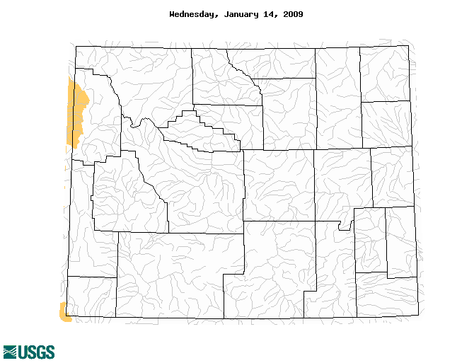 This map is updated at least daily.
Click on the map to view the most recent version.
This map is updated at least daily.
Click on the map to view the most recent version.
|
