| 1300 |  |
A plaque in the steps leading down to the Mississippi River commemorates the highest flood ever recorded at St. Louis, the flood of 1993. On August 1, 1993, the Mississippi River reached the level of the plaque. Note street and river in upper left corner of image. The river reached 49.58 feet above normal during this flood. |
St. Louis, Missouri, Mississippi River 2003 |
1301 |  |
Description not available. |
Great Falls, Potomac River, Maryland |
1302 |  |
Description not available. |
Great Falls, Potomac River, Maryland |
1303 |  |
Description not available. |
Great Falls, Potomac River, Maryland |
1304 |  |
Description not available. |
Great Falls, Potomac River, Maryland |
1305 |  |
Description not available. |
Great Falls, Potomac River, Maryland |
1306 |  |
Description not available. |
Great Falls, Potomac River, Maryland |
1307 |  |
Fire engine from Engine Company No. 10 caught in flood. |
Columbus, Ohio 1913 March 25 |
1308 |  |
Broken levee at Sandusky Street |
Columbus, Ohio 1913 March 25 or 26, 1913 |
1309 |  |
State Street Bridge just beginning to break apart. |
Columbus, Ohio 1913 March 25 or 26, 1913 |
1310 |  |
Glenwood Avenue - a rowboat was the mode of transportation. |
Columbus, Ohio 1913 March 25 or 26, 1913 |
1311 |  |
Row boat leading a horse to safety on West Town Street. |
Columbus, Ohio 1913 March 25 |
1312 |  |
Cypress Avenue showing where 13 people were rescued from a tree. |
Columbus, Ohio 1913 March 26 |
1313 |  |
A rescue boat rowing through Columbus. |
Columbus, Ohio 1913 March 25 |
1314 |  |
Water rushing over bent and broken railroad tracks. |
Columbus, Ohio 1913 March 26 |
1315 |  |
Town Street Bridge broken from flood waters. |
Columbus, Ohio 1913 March 25 |
1316 |  |
Horse still in harness needing rescue near State and Mill Street. |
Columbus, Ohio 1913 March 25 or 26, 1913 |
1317 |  |
Remains of Hill's Grocery near Sullivant and Cypress Avenues. |
Columbus, Ohio 1913 March 25 or 26, 1913 |
1318 |  |
Damage near the corner of Rich and Dakota Avenues. |
Columbus, Ohio 1913 March 25 or 26, 1913 |
1319 |  |
Broad Street near the B&O Railroad tracks showing box car on side with torn up track. |
Columbus, Ohio 1913 March 25 or 26, 1913 |
1320 |  |
The corner of Town Street and Rogers Avenue. |
Columbus, Ohio 1913 March 25 or 26, 1913 |
1321 |  |
The remains of the Baltimore and Ohio railroad bridge at Sullivant Avenue. |
Columbus, Ohio 1913 March 25 or 26, 1913 |
1322 |  |
Industrial facilities near Broad Street. |
Columbus, Ohio 1913 March 25 or 26, 1913 |
1323 |  |
Broken levee at Sandusky Street. |
Columbus, Ohio 1913 March 25 or 26, 1913 |
1324 |  |
Flood damage. |
Columbus, Ohio 1913 March 25 or 26, 1913 |
1325 |  |
Flood damage on Glenwood Avenue. |
Columbus, Ohio 1913 March 25 or 26, 1913 |
1326 |  |
A view of Rogers Avenue. |
Columbus, Ohio 1913 March 25 or 26, 1913 |
1327 |  |
Police carrying a victim of the 1913 flooding. |
Columbus, Ohio 1913 March 25 or 26, 1913 |
1328 |  |
The remains of Doddington Lumber Yard. |
Columbus, Ohio 1913 March 25 or 26, 1913 |
1329 |  |
Washed out railroad tracks on the west side of Columbus. |
Columbus, Ohio 1913 March 25 or 26, 1913 |
1330 |  |
Damage at Broad Street and Rogers Avenue. |
Columbus, Ohio 1913 March 25 or 26, 1913 |
1331 |  |
All that is left of a home on Sandusky Street. |
Columbus, Ohio 1913 March 25 or 26, 1913 |
1332 |  |
Chicago Avenue with automobiles. |
Columbus, Ohio 1913 March 25 or 26, 1913 |
1333 |  |
A rescue boat on Broad Street. |
Columbus, Ohio 1913 March 25 or 26, 1913 |
1334 |  |
T&OC&W. Yard (may not have read abbreviation correctly). Near Broad Street. |
|
1335 |  |
An early Signal Service weather map on record in NOAA Library - September 1, 1872 Careful compilation and study of these maps led to scientific forecasting. In: "Daily Bulletin of Weather-Reports ... for the Month of September, 1872 |
September 1, 1872 |
1336 |  |
United States weather map for the day |
Ca. 1900 |
1337 |  |
Signal Tower for Storm Warning Flags used by day, lanterns by night. Used to warn mariners In: "The Boy and the U.S. Weather Men", 1917, p.236 |
Ca. 1910 |
1338 |  |
Coast Guard aircraft used to drop hurricane warnings to sponge fishermen |
West coast of Florida Ca. 1938 |
1339 |  |
National weather map outside of Department of Commerce Building |
Ca. 1940 |
1340 |  |
Among earliest Signal Service Weather maps |
August 26, 1871 |
1341 |  |
Signal Service Weather map showing huge storm system over Great Lakes region |
December 29, 1889 |
1342 | 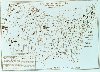 |
Weather Bureau weather map showing cold wave in center of country Northeaster attacking mid-Atlantic states |
January 25, 1905 |
1343 |  |
Northeaster pounding New England while brutally cold in Chicago |
December 30, 1909 |
1344 |  |
Weather Bureau kiosk helping get out the word to small town America |
Ca. 1910 |
1345 |  |
Weather Bureau kiosk helping get out the word to small town America |
Ca. 1910 |
1346 |  |
Weather Bureau signals for informing the public |
|
1347 |  |
Plotting the weather for the navigators of the air |
Ca. 1935 |
1348 |  |
Young entrepreneur uses weather as a selling point |
Ca. 1925 |
1349 |  |
Typical air weather products available for pilots |
Ca. 1950 |

