Regional Information for the Pacific Basin
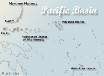
The Pacific Basin area covers the six island jurisdictions of American Samoa, Commonwealth of the Northern Mariana Islands (CNMI), Federated States of Micronesia (FSM), Guam, Republic of the Marshall Islands (RMI), and Republic of Palau (Palau), as well as the Armed Forces Pacific. The islands are spread over an area roughly the size of the continental US.
The areas fall into two categories politically--flag territories and independent countries associated with the US through compacts of free association. American Samoa, CNMI and Guam are all flag territories, which makes them officially part of the United States. Their citizens are also US citizens. FSM, RMI and Palau are all independent countries with compacts of free association with the US. This means that the US provides development assistance and defense, and that citizens can move freely across US borders.
Communication both within the area and between the area and the mainland can be challenging because it ranges over sixteen time zones. Be careful: even the date may differ as the international date line runs through the region. Further complicating matters, although California (like the vast majority of the United States) observes daylight saving time, none of the six island jurisdictions does. A listing of detailed current times and the exact location of the date line is available from Worldtimezone.com.
Network members in the Pacific Basin can be located through the NN/LM Members Directory.
About the Pacific Basin
- Armed Forces Pacific includes the Army, Navy, Air Force and Marines for the Asia-Pacific area. The Asia-Pacific area extends from the west coast of the United States mainland to the east coast of Africa and from the Arctic to Antarctic, including the states of Alaska and Hawaii. The area includes over 50% of the earth's surface and almost 60% of the world's population. More background information.
- American Samoa is part of Polynesia, and is located about 2,200 miles southwest of the Hawaiian Islands. It consists of six islands, with a total land area of 77 square miles. The capital is Pago Pago, on Tutuila. Many Samoans have migrated to the US; there are now more American Samoans living off-island than on-island. More background information.
- Commonwealth of the Northern Mariana Islands (CNMI) is made up of 22 islands, 5 of which are occupied. It has a total land mass of 184 square miles. The capital of Chalan Kanoa is located on Saipan. The majority of the population is Chamorro, although there are also significant groups of Filipinos and Carolinians. Chamorro is also the principal language, although English is the official language and Japanese is also common. More background information.
- Federated States of Micronesia (FSM) includes more than 600 islands in the Caroline Islands Archipelago, which total 271 square miles. The country is divided into 4 states (Yap, Chuuk, Pohnpei and Kosrae), and the capital is Palikir (located on Pohnpei). There are 8 distinct local languages, and many more local dialects. More background information.
- Guam is a single island located about 5,800 miles east of San Francisco. It is physically part of the Mariana Islands, and has a land area of 209 square miles. The native people of Guam are the Chamorro, and the Chamorro language and English are the two official languages. In addition there are significant populations of Chinese, Japanese and Koreans, as well as many other Pacific islanders. Guam is also the home of Andersen Air Force Base, Guam Naval Station, and University of Guam. More background information.
- Republic of Palau (Palau) comprises 340 islands which lie 830 miles southwest of Guam. The total land mass for the territory is 188 square miles, and the provisional capital is Koror Island. Palau has a slight negative population growth rate, due in part to Palauans' willingness to migrate. Palauan communities can also be found on Guam, Hawaii and in the western US. More background information.
- Republic of the Marshall Islands (RMI) lies just to the east of the Federated States of Micronesia, and is made up of coral atolls totaling 70 square miles. Atolls are generally oval coral reefs surrounding a lagoon. The largest atoll is Kwajalein, with a land area of 6 square miles. The capital is Dalap-Uliga-Darrit, located on Majuro Atoll. These two atolls are also the most populated. The Marshallese are Micronesian, and speak Marshallese and some English. More background information.
Key Health Documents
- Pacific Partnerships for Health was produced by the Institute of Medicine at the request of the US Department of Health and Human Services to examine the issue of health in the Pacific Basin area. It provides background on the area, an overview of health in the area, and a strategic plan for the 21st century.
- A Report on the State of the Islands 1999 was prepared by the Department of the Interior and provides detailed information on each of the areas.
- DefenseLINK News: Pacific Lifeline: Tripler Medics Treat Island Ills is an article that provides a brief overview of the past and present of healthcare in the Pacific Basin.
- Interagency Coordinated Assets for Insular Health Response - Assessments and reports for each insular area will be completed by June 2009.
Emergency Preparedness and Response Resources
- American Samoa Territorial Emergency Management Coordination (TEMCO)
- Office of Civil Defense (Government of Guam)
- Guam Homeland Security/Office of Civil Defense
- Emergency Preparedness and Response
- NN/LM Emergency Preparedness & Response Toolkit
Telehealth
- Office for the Advancement of Telehealth is a division of US Department of Health and Human Services. This site provides information on telehealth in general, including sources of grants.
- Telemedicine Information Exchange (TIE) Telemedicine Programs Database: Requested Program provides specific information including the Pacific Islands Health Care Project.
Library Information
- Assessing the Information Needs of Health Professionals in the Pacific Basin: Final Report -- Pacific Southwest Region of the National Network of Libraries of Medicine. Louise M. Darling Biomedical Library, University of California, Los Angeles, Los Angeles, CA, July 31, 1992.
- Hawai'i-Pacific Chapter of the Medical Library Association
- Innovations in Networking to Provide Electronic Delivery of Documents to Health Professionals in the Western Pacific is an article on innovative information services to healthcare professionals in the Pacific Basin area, written by Arlene Cohen, Claire Hamasu and Irene M. Lovas.
- Libraries of Asia Pacific Directory (LAP) - Directory of Libraries and Archives in the Pacific Islands
- The NN/LM Membership Directory includes Network members in the Pacific Basin. Search by city, county, state, zip code or area code. You can also search by institution, library, or staff member's name, or limit by type of library or other features. Make sure your browser cookies are turned on.
Statistical Information
- Census 2000 Results for the Island Areas are now available, provided by the US Department of Commerce. As of May 2002, the Demographic Profile was available, and further information was scheduled for release in 2002 and 2003.
- Secretariat of the Pacific Community provides a wealth of information on land, marine, health, and socio-economic resources on the Pacific Islands, which includes Melanesia (West), Polynesia (Southeast) and Micronesia (North).
- Statehealthfacts.org, is a project of the Henry J. Kaiser Family Foundation and is designed to provide free, up-to-date, and easy-to-use health data on all 50 states, Guam, Puerto Rico and the Virgin Islands.
- Statistics Site from the US Department of the Interior Office of Insular Affairs provides information on each of the areas. Click on the area's flag for specific information.
- World Health Organization - Western Pacific Region -- Look for the links to specific countries for a summary of country situation and trends, health status, national health priorities, health resources, socioeconomic and health indicators, etc.
Special Populations
Carolinian
Carolinians, who migrated from the central Caroline Islands in the 19th century, make up about 12% of the population of CNMI, in addition to being the primary population group in FSM and Palau.
Chamorro
The Chamorro are the native people of Guam, who have a language that is distinct from the other Micronesian dialects of the area. The language has been significantly impacted by Spanish and Filipino-Tagalog, and is spoken widely throughout the Marianas.
- Guam History, People and Culture provides both historical and current information on the Chamorro culture.
- Hafa Adai Todos! is maintained by a group of Chamorros in the San Francisco area and provides cultural information, including language lessons and recipes.
Filipino
About 14% of the population of CNMI and 25% of the population of Guam is Filipino. The majority of Filipinos in the area are from the Tagalog group.
- Philippine Cultures, provided by the National Commission for Culture and the Arts (NCCA) of the Philippine Islands, has cultural information related to the Philippine Islands and Filipinos.
Micronesian
Micronesian is actually a broad designation that encompasses high-island and low-island groups. The high-island group incorporates the Chamorros, Palauans, Yapese, Trukese, Pohnpeians, Kosraeans, and some of the inhabitants of Nauru. The low-island group consists of the population of the numerous atolls in the area. Although low-island populations are sometimes related to the nearest high island, they are generally quite distinct. The area is incredibly diverse, containing 15 separate, mutually unintelligible languages.
- Culture--Federated States of Micronesia is provided by the FSM Visitor's Center and has information on the FSM cultural background.
- Micronesian Culture in Kosrae provides information on Micronesian culture and history on Kosrae.
- Resources on the Marshall Islands--Culture provides links to information on Marshallese culture and history.
Samoan
The majority of people in American Samoa are Samoan, but there are significant numbers in other local areas as well. The Samoan people are Polynesian. Most speak English in addition to Samoan.
- Fa'a Samoa describes the Samoan Way, as well as providing links to related sites.
- Voices of the Samoan Community provides information on characteristics of off-island Samoan communities, particularly the one in the Seattle area.
Medically Underserved Areas/Populations (MUA/Ps)
MUA/Ps are areas or populations designated by the Shortage Designation Branch, part of the Health Resources and Services Administration (HRSA) as not having sufficient access to medical care. If an area is designated MUA, then the entire population is covered, if the designation is MUP, only a specific population is. Occasionally, regions receive a designation of GOV, which means that the state governor requested that the area be included due to local barriers and/or health conditions. The MUA/P designation is often important when obtaining grants or other funding.
The most accurate and up-to-date source of this information is the HRSA database. To find out if a particular area is designated, first look up the county. Each service area is given a descriptive name, and comprises either the whole county (WH), a partial county (PC), a multi-county area (MC), or a multi-state (MS) area. It may be necessary to look up specific areas by census tract. These numbers can be identified by entering a street address into American FactFinder. Tip: print out the Data Dictionary for MUA/P List prior to looking up information.
Additional Resources
- Charting the Pacific is a site that provides cultural and historic information on the Pacific region.
- Guampedia - the Guam online encyclopedia is an ongoing project designed to provide accessible, accurate information about the rich heritage of Guam, its natural environment, history, religion, politics and many other topics.
- Pacific Health Dialog - a medical journal devoted to community health and clinical medicine in the Pacific Islands
- Pacific Islands Report provides news for the entire Pacific region.
- Pacific Resources for Education and Learning (PREL) provides information on a variety of children and education related issues in the Pacific Basin area, including children's health and health education.
- Press Releases from the US Department of the Interior Office of Insular Affairs provide background on the area in general.
- Samoanet -- A portal that brings people to American Samoa.
- Worldwide Governments on the WWW provides links to a broad variety information on American Samoa (under Samoa, American), Commonwealth of the Northern Mariana Islands, the Federated States of Micronesia (under Micronesia), Guam, the Republic of Palau (under Palau), and the Republic of the Marshall Islands (under Marshall Islands).
Government Information Portals
- FedStats provides access to statistics prepared by over 100 federal agencies. Statistics are available on a state and community level.
- FirstGov provides a search engine and topical indexes for US state and federal information. To search for information on a particular state, use the form in the upper left corner. The site also supports searching for information on American Samoa, Guam, the Mariana Islands, the Marshall Islands and Micronesia.
- Google Search <Uncle Sam> searches government information on all levels using the standard Google interface and algorithm.
- State and Local Government on the Net provides links to government information on a state and local level for the fifty states, as well as selected US-associated areas such as Guam.
