Located in the Upper Green River Basin of west-central Wyoming, the Jonah Natural Gas Field contains one of the richest natural gas concentrations in the United States, currently estimated at more than 14 trillion cubic feet. The Jonah Field is part of the larger Wyoming Basin sagebrush ecosystem, which provides natural resource values such as habitat for wildlife, forage for livestock, and areas for recreation. In order to balance the Nation’s energy needs with Federal and State mandates to conserve living resources, the Jonah Interagency Mitigation and Reclamation Office (JIO) was created to provide overall management of monitoring and mitigation activities related to gas exploration and development, both on and off the Jonah Field. The JIO uses innovative approaches to encourage industry to minimize the footprint of development, maximize recovery of natural gas, and facilitate the reclamation process.

To help the JIO efficiently track significant amounts of data and meet management objectives, the USGS Fort Collins Science Center Web Applications Team developed the Jonah Infill Data Management System. This Web-based application collects information that the JIO will use to assess reclamation efforts and determine whether (1) interim and long-term requirements and criteria are being met, (2) reclamation and monitoring protocols are providing appropriate and sufficient information, and (3) data are being collected as specified. The information will support decisionmaking regarding reclamation activities associated with oil and gas activities in the Jonah Field—and for the first time, it will allow trends to be evaluated in real time.
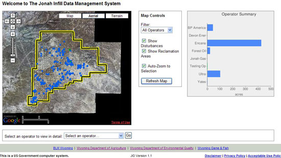
When first opened, the application displays a summary page of the entire Jonah Field (Figure 1). From there, users can explore the field using the embedded mapping application or choose to view detailed disturbance and reclamation data and reports. The application uses a customized interface designed to help both land managers and gas company operators collect and share standardized reclamation assessment and monitoring data. Both agency personnel and gas company operators were involved in the design process to ensure that the user interface would be straightforward and the reporting requirements clearly defined.
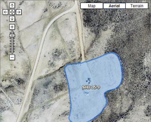
The data on the opening page map (shown as a small blue shape on the map in Figure 1) represents a disturbed area in the Jonah Gas Field. To create these data points, users upload polygons that represent a disturbed or reclaimed area. The blue area in Figure 2 is an example of what a polygon looks like once it has been uploaded. Qualitative and quantitative data on reclamation efforts for these disturbed areas are then stored in a clearinghouse, allowing users to perform simple and complex queries and produce maps and reports.
In addition to storing area-specific data, the application compiles summary information across all disturbed areas. This allows users to view information on a selected area, a selected gas company, and the entire Jonah Field. These features will enable the JIO to evaluate large amounts of data and derive information that was previously unavailable, such as total acreage impacted, spatial changes over time, habitat fragmentation, stage of reclamation by pad or as a summary, and success of reclamation efforts. Future plans include public access to summary reports, thus providing an effective tool for public outreach.
Tim Kern
Fort Collins Science Center
2150 Centre Ave., Bldg. C
Fort Collins, CO 80526-8118
Phone: 970.226.9366
Fax: 970.226.9230
Email: kernt@usgs.gov
Pat Anderson
Fort Collins Science Center
2150 Centre Ave., Bldg. C
Fort Collins, CO 80525
Phone: 970.226.9488
Fax: 970.226.9230
Email: andersonpj@usgs.gov

![]() U.S. Department of the Interior | U.S. Geological Survey
U.S. Department of the Interior | U.S. Geological Survey
URL: http://www.fort.usgs.gov/JIO/Default.asp
Page Contact Information: AskFORT@usgs.gov
Page Last Modified: 3:24:49 PM
