|
||
Natural Hazards >> Fires >> Fires in Southern United States
| ||||
|
Fires in Southern United States
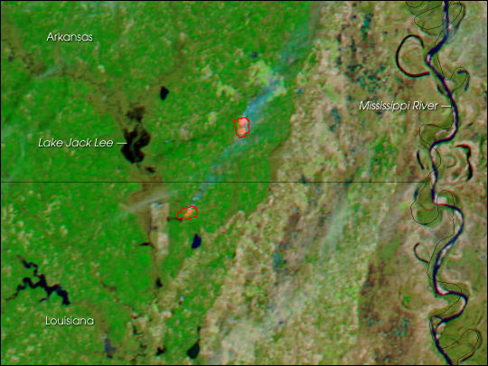
The combination of parched vegetation and gusty winds that caused dozens of devastating fires in New Mexico, Texas, and Oklahoma in the first week of 2006 has brought a similar fate to a wider area of the southern United States in the second week of January. Among the newly affected states is Arkansas. This image shows the southeast corner of the state, near the border with Louisiana. Two large fires were detected by the Moderate Resolution Imaging Spectroradiometer (MODIS) on NASA’s Aqua satellite when it collected this image on January 8, 2006. The image has been enhanced by the inclusion of shortwave and near-infrared energy that MODIS detected. Vegetation appears bright green, bare or thinly vegetated ground is tan, water is dark blue, and the actively burning areas of the fire appear bright pink (outlined in red). The image is shown at MODIS’ maximum spatial resolution of 250 meters per pixel. The MODIS Rapid Response Team provides daily images of the area in a variety of formats. NASA image courtesy the MODIS Rapid Response Team, Goddard Space Flight Center Recommend this Image to a Friend Fires: Topic Home | Archive | Related Links Natural Hazards Home | Section FAQ |
Where in the World
Image Posted January 09, 2006 Satellite & Sensor Aqua- MODIS Other Images for this Event Posted: Jan 09, 2006 Posted: Jan 04, 2006 Posted: Jan 03, 2006 Posted: Dec 29, 2005 Fires Latest Events Fires in Madagascar Fires near Los Angeles, California Fires in Oregon and Northern California Fire in the Kalahari Fires in Mozambique, Zimbabwe, and South Africa Fires in Central South America | |||
|
Subscribe to Natural Hazards
About the Earth Observatory & Natural Hazards Contact Us Privacy Policy and Important Notices Responsible NASA Official: Lorraine A. Remer Webmaster: Goran Halusa The Earth Observatory is part of the EOS Project Science Office located at NASA Goddard Space Flight Center. |