
|
|
East Maui, or Haleakala--
A Potentially Hazardous Volcano
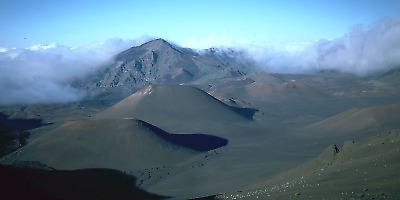
View east across Haleakala Crater, with young cinder cones in foreground.
When asked about Hawaiian volcanoes, most people imagine the Island of Hawai`i and its eruptions at Kilauea or Mauna Loa volcanoes. But East Maui volcano has witnessed at least ten eruptions in the past 1,000 years, and numerous eruptions have occurred there in the past 10,000 years. Thus, East Maui's long eruptive history and recent activity indicate that the volcano will erupt in the future.
Haleakala National Park is the most visited part of East Maui. The Hawaiian name Hale-a-ka-la (lit., house of the sun), is now nearly synonymous with the entire shield of East Maui volcano. Early Hawaiians, however, applied the name only to the summit area, the site where the demigod Maui snared the sun and forced it to slow its journey across the sky.
The oldest lava flow exposed on East Maui is about 1.1 million years in age. It is part of a sequence of flows emplaced near the end of shield building on East Maui. The time estimated to build a volcano from ocean floor to the end of its shield-building stage is thought by some scientists to be about 0.6 million years. East Maui volcano probably began its growth about 2.0 million years ago.
Volcanism of the past 30,000 years on East Maui has been focused along the southwest and east rift zones. These two volcanic axes together form one gently curving arc that passes from La Perouse Bay (southwest flank of East Maui) through Haleakala Crater to Hana on the east flank. The alignment continues east beneath the ocean as Haleakala Ridge, one of the longest rift zones along the Hawaiian Islands volcanic chain. The on-land segment of this lengthy volcanic line of vents is the zone of greatest hazard for future lava flows and cindery ash.
East Maui Facts
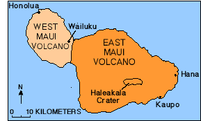
Map of the Island of Maui
|
Location 20.718 N 156.254 W
Elev. Above Sea Level
Area
Volume |
Most Recent Eruption
Perhaps about A.D. 1790, but newly
obtained radiocarbon ages suggest the most recent eruption probably occurred
earlier, sometime between A.D. 1480 and 1600. (see Volcano
Watch essay, September 9, 1999).
Number of Historical Eruptions
See recent eruption description above.
Summit Crater
A large topographic depression, Haleakala Crater, occupies the
summit region of East Maui volcano. The crater is breached at
its northwest and southeast corners by large valleys that
drain to the north and south coasts, respectively. The crater
originated by erosion, according to most published accounts and additional
recent research.
- Dimensions: 3.5 x 12 km, elongate east-west
- Depth: 860 m
- Estimated age: formed between 120,000 and 150,000 years ago (see Volcano Watch essay, March 8, 2001)
About 1.1 million years
Estimated Age of On-land Eruptions
Numerous small lava flows in past 30,000 years;
slopes of volcano mantled by lava flows 700,000 to 150,000 years in age.
Estimated Age of Inception of East Maui Volcano
About 2.0 million years ago
Hawaiian Volcano Stage
Postshield stage
(see Volcano
Watch essay, December 27, 2001
![]()
![]()
![]()
![]()
![]()
![]()
![]()
![]()
![]()
![]()
![]()
Contact: hvowebmaster@usgs.gov
Updated: 20 February 2003 (srb)