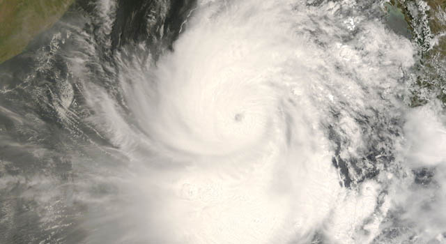
 In early May 2008, Cyclone Nargis passed over Burma (Myanmar) after forming in the Bay of Bengal.
 February 26, 2009
PASADENA, Calif. - A "pre-existing condition" in the North Indian Ocean
stoked the sudden intensification of last year's Tropical Cyclone Nargis
just before its devastating landfall in Burma, according to a new NASA/university
study. The cyclone became Burma's worst natural disaster ever and one
of the deadliest cyclones of all time.
Scientists at the National Taiwan University, Taipei; and NASA's Jet
Propulsion Laboratory, Pasadena, Calif., used data from satellite altimeters,
measurements of ocean depth and temperature and an ocean model to analyze
the ocean conditions present at the time of the catastrophic storm. Nargis
intensified from a relatively weak category 1 storm to a category 4 monster
during its final 24 hours before making landfall on May 2, 2008.
Lead author I-I Lin of National Taiwan University and her team found the ocean
conditions Nargis encountered created the perfect recipe for disaster.
Cyclones thrive on warm layers of ocean water that are at least 26 degrees
Celsius (79 degrees Fahrenheit). As they traverse the ocean, they typically
draw deep, cold water up to the ocean surface, a process that limits their
ability to strengthen, and even weakens them as they evolve. However, Nargis
passed over a pre-existing warm ocean feature in the Bay of Bengal where upper
ocean warm waters extended deeper than normal, from 73 to 101 meters (240 to 331 feet).
"This abnormally thick, warm water layer, which formed about a month earlier,
kept deeper, colder waters from being drawn to the surface, increasing the energy
available to fuel Nargis' growth by 300 percent," said Lin. "Combined with other
atmospheric conditions conducive to strengthening, this warm ocean feature allowed
Nargis to reach speeds of 115 knots [213 kilometers, or 132 miles, per hour] at
landfall. Had Nargis not encountered this warm ocean feature, it would likely not
have had sufficient energy to intensify rapidly."
Nargis' rapid intensification occurred predominantly over warm ocean regions where
sea surface temperatures ranged between 30 and 30.2 degrees Celsius (about 86 degrees
Fahrenheit) and sea surface heights ranged from 6 to 20 centimeters (2.4 to 7.9 inches)
above normal. Between May 1 and 2, 2008, the storm intensified from category 1 to
category 4. When Nargis briefly passed outside the warm ocean region on May 2, it
weakened somewhat, only to strengthen once again as it returned to the warm ocean
feature. Warm ocean features in the Gulf of Mexico contributed to the rapid intensification
of hurricanes Katrina and Rita in 2005.
Lin said the research will contribute to improving our understanding of and ability
to forecast catastrophic events like Nargis in the future, reducing loss of life and
property. "Such a capability is particularly needed in developing countries, where
less advanced cyclone monitoring and warning systems can leave people with little
time to escape from disaster," she said.
The scientists compared the thermal structure of the upper ocean waters within the
warm ocean feature during the storm with its thermal structure under normal climatological
conditions. Study data came from the international Argo float program, NASA's
Jason-1 satellite, the European Space Agency's Environmental Satellite, the U.S.
Navy's GEOSAT Follow-On satellite and NOAA's Global Temperature and Salinity Profile
Program data base. The satellite data were used to derive the upper ocean thermal
structure for regions where no suitable direct measurements were available.
"This research demonstrates a significant potential benefit of using altimeter data for
operational weather forecasting and tropical cyclone intensity predictions," said study
co-author Tim Liu of JPL. "Current hurricane analyses include variations in ocean heat,
which can be revealed by ocean altimeters. Satellites like NASA's Jason-1 and Ocean
Surface Topography Mission/Jason-2 make important contributions to the operational
monitoring and prediction of tropical cyclones, as have other NASA satellites."
Results of the study were published this month in Geophysical Research Letters.
For more information on Jason-1 and NASA's satellite altimetry programs, visit:
http://sealevel.jpl.nasa.gov . For more information on NASA programs, visit: http://www.nasa.gov .
JPL is managed for NASA by the California Institute of Technology in Pasadena.
Media contact: Alan Buis 818-354-0474
Jet Propulsion Laboratory, Pasadena, Calif.
Alan.buis@jpl.nasa.gov
2009-031
![]()
| 1 | Soft Ground Puts Spirit in Danger Despite Gain in Daily Energy |
| 2 | Hubble Photographs a Planetary Nebula to Commemorate Decommissioning of Super Camera |
| 3 | The Camera That Saved Hubble... Twice: JPL's Wide Field and Planetary Camera 2 |
| 4 | NASA Releases Interactive 3-D Views of Space Station, New Mars Rover |