|
The images below are created from data that is archived and distributed by the GES DISC DAAC.
For more information about any of these images or dataset,
please contact help-disc@listserv.gsfc.nasa.gov.
You can also view the following image galleries:
|
Featured Images: |
 |
The global images in this gallery are created from data collected daily by the AIRS instrument on the Aqua satellite.
|

|
AIRS calibrated Vis/NIR radiances. This hurricane Isabel image is a false color composite using 0.71-0.92 µm, 0.58-0.68 µm, and 0.40-0.44 µm bands. The nadir pixel resolution is 2.3 km.
|

|
As Hurricane Isabel intensified and weakened on its way to the East Coast, the Tropical Rainfall Measuring Mission (TRMM) observed Isabel many times. The TRMM Precipitation Radar (PR) is the only instrument in space that can provide detailed three-dimensional rainfall measurements.
|
|
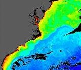
SeaWiFS false-color image of chlorophyll concentration data for the east coast of the United States. In the upper right area of this image, the boundary between higher (yellow and green) and lower (blue) chlorophyll concentrations marks the position of the Gulf Stream.
|

|
Rainfall image, observed by TRMM at 21:05 UTC on 08/13/2004. (Image courtesy of TRMM Project).
|
|
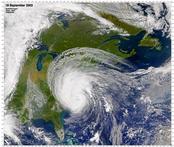
SeaWiFS image of the east coast of the United States, acquired on September 18, 2003, as Hurricane Isabel was about to make landfall on the Outer Banks of North Carolina.
|

|
TOMS-EP measures the second largest ozone hole! The Antarctic ozone hole reached its maximum on September 24, 2003, slightly larger than the North American continent, but smaller than the largest ever recorded, on September 10, 2000.
|
|
 |


