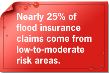
Understanding Your Area
Changing weather patterns, erosion, and development can affect floodplain boundaries. FEMA is currently updating and modernizing the nation’s Flood Insurance Rate Maps (FIRMS). These digital flood hazard maps provide an official depiction of flood hazards for each community and for properties located within it.
FEMA has published almost 100,000 individual Flood Insurance Rate Maps (FIRMs). See your map and learn how to read it so you can make informed decisions about protecting your property, both financially and structurally.
Discover Flood Risk Scenarios >>
Learn your risk, and find an agent, by taking Your Risk Profile.


500 C Street SW, Washington, D.C. 20472
Disaster Assistance: (800) 621-FEMA, TTY (800) 462-7585
U.S. Department of Homeland Security
FEMA Home | Contact FEMA |
Privacy Policy | Important Notices |
FOIA | USA.gov | DHS
