Public Health
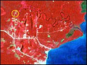
Satellite imagery allows scientists to map the environment. Regions that flood seasonally, or have standing water, are good breeding grounds for mosquitoes. The yellow circle in this Landsat image indicates an area around a cluster of houses with multiple malaria cases, and was used to generate a landcover map. (Image courtesy Uniformed Health Services)
Many chronic and infectious diseases are related to environmental conditions. Organisms such as ticks and mosquitoes (called vectors) transport these diseases, and variability in rainfall and temperature has a major influence on the distribution and quantity of these pests. Recent outbreaks of West Nile Virus and other vector-borne diseases have illustrated the importance of having accurate and timely information to predict and respond to epidemics.
High concentrations of ground level ozone, particulate matter, and/or other atmospheric pollutants can worsen respiratory diseases such as asthma and emphysema. The Center for Disease Control and Prevention (CDC) maintains decision support systems for public health that provide vital information on these conditions and allow for the prediction of disease outbreaks. NASA's goal is to help determine how weather, climate, and other key environmental factors correlate with the occurrence of chronic and infectious diseases. Once verified, validated and benchmarked, these relationships can be assimilated into surveillance systems such as the Environmental Public Health Tracking Network to track and predict disease. Other partners, such as the National Institutes of Health (NIH), and the Environmental Protection Agency (EPA) are also part of this effort.
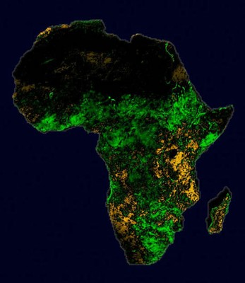
By closely monitoring the vegetation in the region affected by increased rainfall, scientists can identify the actual areas affected by outbreaks of Rift Valley Fever, a mosquito-borne disease that can be fatal to humans and animals. Scientists use satellite images to show regions of Africa that are greener (and wetter) than normal or more brown (and drier) than normal.
NASA's satellites offer a wealth of information for input into the decision support systems used for public health. The Terra and Aqua missions return information on such factors as vegetation, forests, flooding, wetlands, soil moisture, surface ultraviolet radiation and surface temperatures. For example, both Terra and Aqua carry the Moderate-Resolution Imaging Spectroradiometer (MODIS), which contributes important information on weather and climate contributions favorable to vectors. In addition, the Tropical Rainfall Measuring Mission (TRMM) also provides important data on precipitation, which can be used to study different habitats.
More missions are planned for the future that will return information related to public health issues, most notably the Global Precipitation Measurement (GPM) mission and the National Polar-orbiting Operational Environmental Satellite System (NPOESS).
| Partner Agency(s): |
CDC, DoD, NIH, EPA, USGS, NOAA
|
| NASA Contributions: |
Observations and modeling of weather, climate and other environmental
factors influencing disease vectors and air quality via Aura, NPP,
Jason, GPM
|
| Partner Agencies Decision Support Tools: |
Environmental Public Health Tracking Network (EPHTN) Arbovirus Surveillance Network (Arbonet) Malaria Modeling and Surveillance (MMS)
|
| Decadal Outcomes of Agencies Use of NASA Data and Information: |
Improved surveillance systems (Arbonet). Integrated environmental factors into EPHTN. Improved accuracy and precision of disease predictions with a corresponding increase in warning time. |