|
During the week of August 9 to 16, Tropical Storm Bonnie and Hurricane Charley, formed in the
western tropical Atlantic Ocean and swept across the Gulf of Mexico successively within a couple of
days. Tropical Storm Bonnie landed on the Florida panhandle coast and quickly dissipated. Hurricane
Charley, on the other hand, was significantly strengthened by the warm waters and the atmospheric
conditions left over or laid down by Bonnie, and traversed the densely populated area of the
Florida peninsula from south of Tampa to Jacksonville, causing significant damage to the local residents and economy.
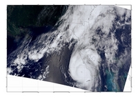
Figure 1: Brightness Temperature Image of Tropical Storm Bonnie, observed by MODIS/Terra on 08/12/2004.
(Image courtesy of the MODIS Data Support Team at NASA's GES DISC DAAC)
|

|
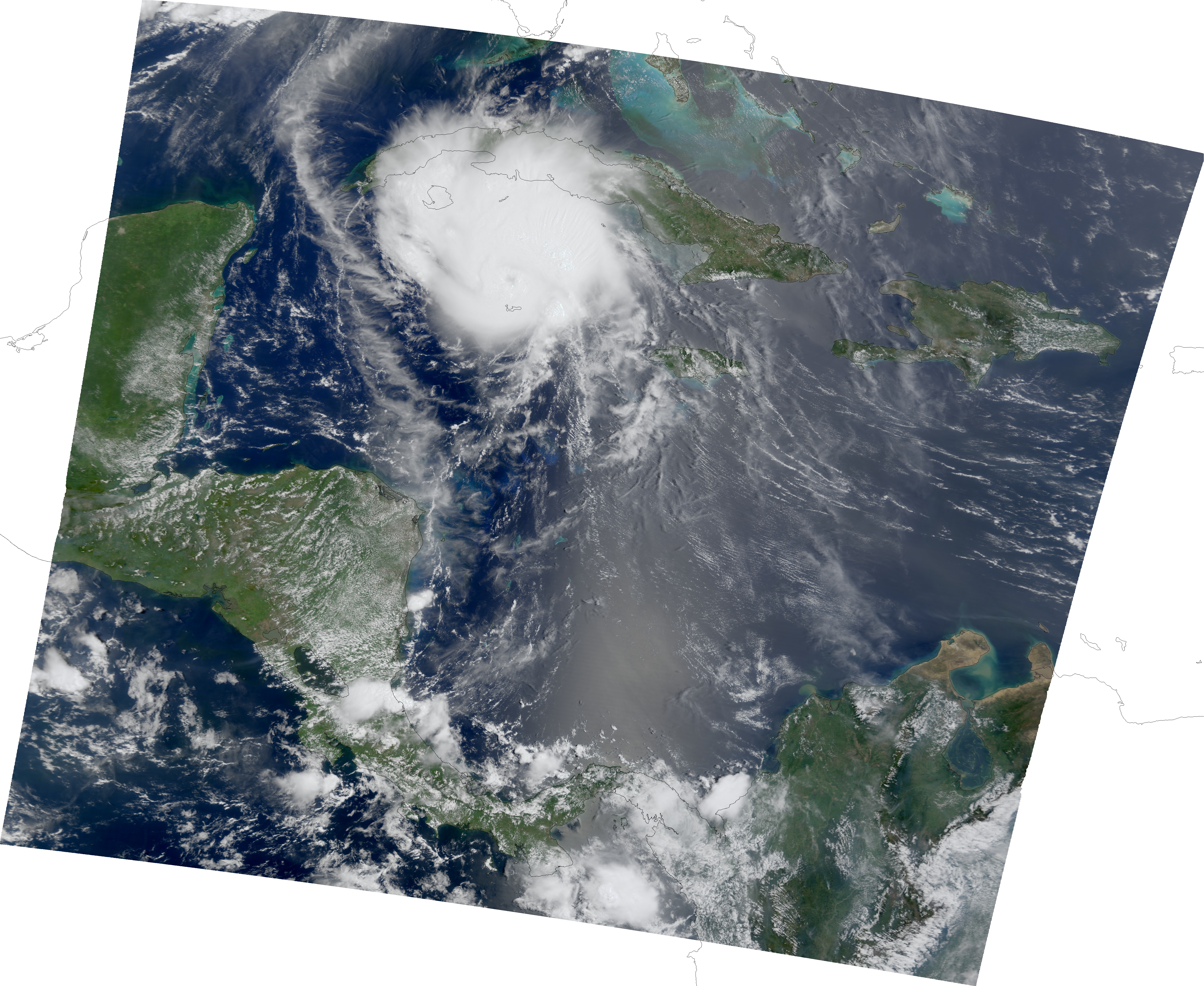
| Figure 2: True Color (RGB) Image of Hurricane Charley, observed by MODIS/Terra on 08/13/2004. (Image courtesy of the Science Support Team at NASA's GES DISC DAAC) |
 |
| Figure 3: Rainfall image, observed by TRMM at 21:05 UTC on 08/13/2004. (Image courtesy of TRMM Project) |
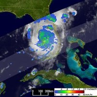 |
Figure 1 shows the brightness temperature observed by the Moderate Resolution Imaging Spectroradiometer
(MODIS) onboard of Terra satellite over the eastern Gulf of Mexico on the night of August 12, 2004. At this time,
Hurricane Charley was still over Cuba and Tropical Storm Bonnie was approaching the Florida Panhandle coast. The cloud top
temperature in the eye of Bonnie is lower than 200 K (-73°C). Significant precipitation has been
produced by Bonnie over the southeastern United States.
Over the next few days, Bonnie landed on the Florida coast and dissipated quickly while
Charley was picking up strength. The true color image observed by MODIS onboard Terra
on August 13 (Figure 2) shows Charley over the southwest Florida shelf. The regular structure
of Charley at this time in comparison with the dispersed structure in Figure 1 suggests that
Charley had strengthened significantly. Charley had been moving northwestward from Figure
1. However, the large-scale atmospheric circulation indicated by the strip of clouds across the
Gulf of Mexico had pushed Charley to move north-northeastward across the Florida Peninsula
during the next few days.
Other Images:
-
MODIS Aqua true color images over the Caribbean Sea on Aug. 12, 2004
Resolution:
0.5 km ( 8.5M),
1 km ( 2.2M)
-
MODIS Aqua true color images over the west Atlantic on Aug. 13, 2004
Resolution:
0.5 km ( 9.0M),
1 km ( 2.5M)
-
MODIS Terra true color images over the Caribbean Sea on Aug. 12, 2004
Resolution:
0.5 km ( 8.0M),
1 km ( 2.3M),
5 km ( 1.9M)
-
MODIS Terra true color images over the Caribbean Sea on Aug. 13, 2004
Resolution:
0.25 km (33.9M),
0.5 km ( 9.2M),
1 km ( 2.6M),
5 km ( 2.2M),
10 km ( 2.2M)
-
MODIS Aqua brightness temperature (daytime) over the Caribbean Sea on August 12, 2004
Resolution:
1 km ( 2.5M)
-
MODIS Terra brightness temperature (daytime) over the Caribbean Sea on August 12, 2004
Resolution:
1 km ( 2.1M)
-
MODIS Aqua brightness temperature (daytime) over the Caribbean Sea on August 13, 2004
Resolution:
1 km ( 1.9M)
-
MODIS Terra brightness temperature (daytime) over the Gulf of Mexico and Florida on August 13, 2004
Resolution:
1 km ( 2.4M)
-
AIRS 11 µm L-1B brightness temperature (daytime) over the Gulf of Mexico and Caribbean Sea on August 12, 2004.
Resolution:
13.5 km
( 399k)
-
AMSU 52.8 GHz brightness temperature (daytime) over the Gulf of Mexico and Caribbean Sea on August 12, 2004.
Resolution:
40.5 km
( 338k)
-
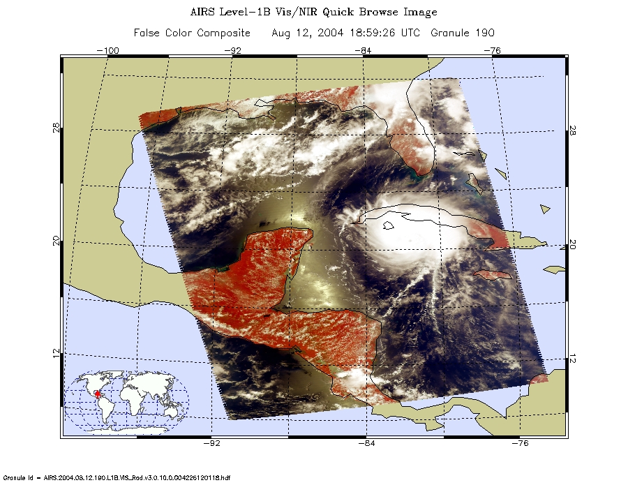
AIRS Visual/Near InfraRed composite false color image (band 1,2,3) over the Gulf of Mexico and Caribbean Sea on August 13, 2004.
Resolution:
2.3 km
( 428k)
-
AIRS 11 µm L-2 brightness temperature (daytime) over the Gulf of Mexico and Caribbean Sea on August 12, 2004.
Resolution:
40.5 km
( 108k)
-
AIRS 11 µm L-1B brightness temperature (daytime) over the Gulf of Mexico and Caribbean Sea on August 13, 2004.
Resolution:
13.5 km
( 357k)
-
AMSU 52.8 GHz brightness temperature (daytime) over the Gulf of Mexico and Caribbean Sea on August 13, 2004.
Resolution:
40.5 km
( 308k)
-
AIRS Visual/Near InfraRed composite false color image (band 1,2,3) over the west Atlantic on August 13, 2004.
Resolution:
2.3 km
( 405k)
-
AIRS 11 µm L-2 brightness temperature (daytime) over the Gulf of Mexico and Caribbean Sea on August 13, 2004.
Resolution:
40.5 km
( 96k)
|
 |


