TOPEX/Poseidon surveys sea-level heights by measuring the
time required for pulses generated by the onboard radar
altimeters to bounce back to the satellite from the sea
surface. This indicates the distance, or range, between the
sea and the satellite. Free electrons in Earth's ionosphere
can delay the return of the radar pulses to the satellite,
this interfering with the accuracy of sea-level
measurements. To correct for this delay, the satellite's
National Aeronautics and Space Administration (NASA)
altimeter makes measurements in two channels: Ku- band (13.6
GHz) and C-band (5.3 GHz). Because the ionospheric range
delay is a function of radar frequency, the difference
between the two measurements provides both a measure of the
integrated electron content and a correction for the range
delay. This is the first dual-frequency altimeter to measure
the ionospheric range correction directly, providing the
first global, high-resolution view of the ionospheric
electron content. The integrated electron content varies
with local time - the maximum level occurs during the day
and the minimum level during the night.
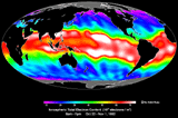
This image shows the daytime integrated electron content
of the ionosphere between October 22 and November 1, 1992.
Magenta (purple) regions contain less than 8 x 10^16
electrons per square meter (a range correction of 1.7
centimeter or less), while white areas contain in excess of
74 x 10^16 electrons per square meter (a range correction of
16.1 centimeters or more). The range correction can reach
values greater than 30 centimeters.
The image shows two prominent aspects of the ionosphere
-- the "equatorial anomaly" and the influence of Earth's
magnetic field. The equatorial anomaly refers to the fact
that the maximum electron concentration is not at the
equator but at about 15 degrees north and south. It is also
clear that the band of maximum ionospheric effect is not
parallel to the geographic equator. Instead, it slants from
north to south across the Pacific Ocean following the
geomagnetic equator and reaches its southernmost point in
the "South Atlantic Anomaly" region just east of South
America.
NASA/JPL/Caltech
JPL Identification #: P-41644