

Images & Animations
-
Credit
NASA/Goddard Space Flight Center Scientific Visualization Studio
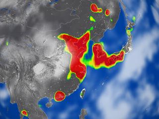
Nitrogen Dioxide concentration over China from September 24, 2004 till November 7, 2004
Nitrogen dioxide, NO2, is a traffic-related pollutant. Emmisions are generally highest in urban rather than rural areas. Annual mean concentrations of nitrogen dioxide in urban areas are generally in the range 10-45 ppb, and lower in rural areas. Levels vary significantly throughout the day, with peaks generally occurring twice daily as a consequence of rush hour traffic. Concentrations can be as high as 200 ppb. Particulate matter is very fine and can be carried deep into the lungs where they can cause inflammation and a worsening of the condition of people with heart and lung disease. Further, the problem is not necessarily concentrated in the inner cities. Because many major road / motorway interchange complexes are situated in semi-rural areas, under conditions of near-stationary traffic, a rapid build-up of engine exhaust pollution can occur, which if the low-level atmospheric conditions are correct, will not be dispersed.
This image is of Nitrogen Dioxide,NO2, on October 16, 2004.
Metadata
-
Sensor
Aura/OMI -
Animation ID
3074 -
Video ID
NONE -
Start Timecode
00:00:00:00 -
End Timecode
00:00:00:00 -
Animator
Lori Perkins -
Studio
SVS -
Visualization Date
2004/12/02 -
Scientist
Ernest Hilsenrath (NASA/GSFC), Mark Schoeberl (NASA/GSFC), Pepijn Veefkind (Royal Netherlands Meteorological Institute KNMI) -
Datasets
Earth at Night -
Keywords
pollutant, nitrous dioxide, urban, cities, kyoto -
DLESE Subject
atmospheric science -
Data Date
2004/09/24 - 2004/11/7 -
Pao ID
G04-064 -
Story URL
http://www.nasa.gov/vision/earth/lookingatearth/aura_first.html -
Animation Type
Stills