Research Programs
By Region
By Subject
By Researcher
Publications
Milestone Reports
|
|
Home > Research > Region > United
States > Wisconsin
Research by Region: United States - Midwest
Illinois | Indiana | Michigan | Minnesota | Ohio | Wisconsin
GLERL research programs emphasize studies in the Great Lakes region.
Below are descriptions of GLERL research programs that take place predominantly
in Wisconsin or within Wisconsin nearshore waters. Additional projects
that may affect Wisconsin, due to the interconnected nature of the ecosystem,
are listed under our Great
Lakes Drainage Basin section. This section includes the many GLERL
research collaborations that are large scale, multi-institution projects
which span large portions of the basin, including parts of Wisconsin.
Wisconsin |
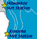
| Real-time Meteorological Observation Network
GLERL's Marine Instrumentation Laboratory has
deployed and is maintaining a real-time network of shore-based meteorological
instrument packages including locations at Milwaukee and Kenosha,
Wisconsin. The meteorological observations obtained from the network
are being used in GLERL's Great
Lakes Coastal Forecasting System to improve nowcasts and forecasts
of wind, waves, water levels, and circulation.
+ Read more |
 |
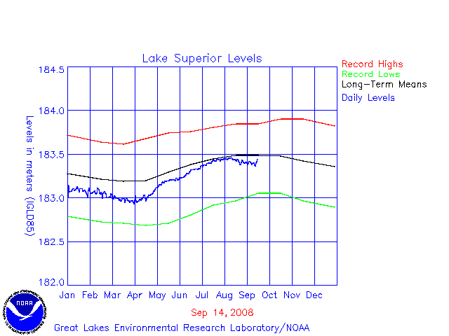
| Lake Superior Daily Water Level Plot
Superior--Daily levels compared with monthly Min, Max, and Mean
levels
+ Read More |
 |
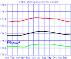
| Lakes Michigan-Huron Daily Water Level Plot
Michigan-Huron--Daily levels compared with monthly Min, Max, and
Mean levels
+ Read More |
 |
Effects of non-indigenous invertebrates on the pelagic food web of Lake Michigan
Our goal is to evaluate the status of the pelagic food web in Lake Michigan at sites where we also have access to historical data. This project encompasses four separate projects to help elicit the status and changes in the pelagic food web of Lake Michigan.
+ Read more |
 |
| Wisconsin Precipitation Data
Two types of downloadable files are available: P_*_DAT files contain
the monthly precipitation data for Wisconsin stations. *-HST files
contain the station history information extracted from the WB 530-1
forms by the National Climatic Data Center (NCDC). These data show
the station number, latitude, longitude, elevation, station name,
and period of record for each station location. These are ZIPPED
files, with one file for each state.
+ Access Data |
|
|
| Great Lakes Bathymetry Maps, Great Lakes Topographic
Relief Maps and Shoreline Data
Lake floor maps and digital files of Great Lakes shorelines, The
bathymetric grids consist of an array containing the average lake
depths in 2-km squares. The digitized shorelines are lists of latitudes
and longitudes for closed loops describing lake and island shorelines.
+ Access maps and data
|
 |
| Great Lakes Sea Grant Extension Office
GLERL has a Great Lakes
Sea Grant Extension Agent onsite to support and promote increased
communication and cooperation between GLERL and the seven Great
Lakes Sea Grant Programs in the region, including the Wisconsin
Sea Grant program. The GLERL/Sea Grant Web Site posts many
valuable Great Lakes resources including the
Great Lakes Water Level Photo Gallery, additional photo galleries,
reports, and seminars and in addition provides extensive links to
Great Lakes Sea Grant Network and GLERL scientific products and
services. |
 |
 
Last updated: 2008-06-05 mbl
|
|