Chapter 2: The Benguela Upwelling Zone
In the first chapter, an image of the island of Tasmania
illustrated the complex interactions that can result between the
currents in the ocean (which are primarily studied in the field of
physical oceanography) and the phytoplankton living in the ocean
(which are part of the field of biological oceanography).
The CZCS image of
Tasmania might make it seem impossible to figure out how such complex patterns
are generated. In many regions of the ocean, however, the patterns are much
simpler. There are some basic processes that cause patterns found in many
different areas of the ocean, all resulting from the same combination of winds,
ocean currents, and the essential elements that allow life to exist in the
ocean.
One of the basic
realities of this research effort can be found in the name of the instrument
that acquired the images -- the CZCS. The first two words in the name are
"coastal zone". If you look at a CZCS image of the whole world, which is
composed of many different smaller scenes obtained over the eight years the
instrument operated, it is immediately obvious that the continents are
surrounded by areas of higher productivity. While some of these areas can be
very broad and others very thin, it is a general observation that there is more
productivity near the coast. When the CZCS was first proposed, no one was sure
that this type of remote sensing observation could actually be made from
space. Yet the scientists did know that the best place to attempt such
observations would be near the coast, where productivity was highest. So the
"mission" of the CZCS was designed to look at various coastal regions. (The
CZCS shared power on the satellite with other Earth observation instruments,
and so it was not operated continuously. This factor makes the CZCS archive
of images a little frustrating to use, because the instrument was always
observing different oceanic regions, and many times these regions were covered
by clouds. In many cases, to make a single image of one entire region of the
ocean, several different images have to be combined. These images are called
composite images, and some of them will be shown in later chapters.)
There is a reason
that coastal areas usually have higher productivity than the open ocean.
Besides sunlight and carbon dioxide from the atmosphere, plants also require
certain elements, called nutrients, for growth. The supply of these nutrients
is generally greater near the coast. The most important nutrients in the
ocean are nitrate (NO3-) and phosphate
(PO4-), though there are other necessary nutrients.
Just as plants on land receive fertilizer with nitrogen and phosphorus to
enhance growth, when phytoplankton receive more nitrate and phosphate, their
growth rate will increase.

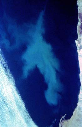
CZCS image of the southwest African coast, showing the high
productivity of the Benguela upwelling zone and associated features of the
Benguela current. This image was obtained on September 29, 1980.
The image shown above is a single CZCS 2-minute scene (the area scanned
by the CZCS in two minutes as it orbited the Earth) of the southern African
coast on September 30, 1980. Along the western coast is an area of very high
primary productivity, as seen by the large areas of red and yellow in the false
color image. The high productivity of this area is due to a fundamental
process in physical oceanography called upwelling. This area is called
the Benguela upwelling zone, because it is locatbutrients that is in their cells
sinks into deep ocean waters. Very slowly, the cells decompose and slowly
dissolve into the deep ocean water. This process enriches the deep waters
with nutrients.
|
 |
Visible light photograph taken from space of a plankton bloom in the
Benguela upwelling zone. The air masses near the coast originate over desert
areas and are therefore very dry, which helps to keep the nearshore area
cloud-free.
Note (September 2002): This image is probably not a plankton bloom,
but is more likely a related geophysical phenomenon that is explained
in the Science Focus! article A Bloom By Any Other Name...
Might Never Be a Bloom At All.
|
|
|
The flow of most surface currents in the ocean is induced by the wind, and
these currents are therefore called wind-driven currents. The northward
direction of the Benguela current is part of the geostrophic flow of
the world ocean, the currents which flow due to the Coriolis force, the force
that results from the rotation of the Earth. One result of the interaction
between the prevailing winds and the Coriolis force is the large-scale
rotational circulation in major ocean basins. These large rotational patterns
are called gyres, and they
result from the necessary
balance between the Coriolis force and pressure gradients in the ocean produced
by winds. In the South Atlantic, the north-flowing Benguela is part of a
counterclockwise gyre; on the South American side of the gyre, the Brazil
Current flows south.
However, the productivity of the Benguela upwelling zone results from a
different principle that is also related to the Coriolis force. This
principle, one of the most important principles of physical oceanography was
determined by physicist V.W. Ekman, who examined the frictional effects of wind
moving over a surface. The net effect is that wind does not make a current flow
in the exact same direction that the wind is blowing. What actually happens is
that the resulting current moves to the right side of the wind direction in the
Northern Hemisphere and to the left of the wind direction in the Southern
Hemisphere At the surface, the current moves about 45 degrees to the right
(or left, in the Southern Hemisphere) of the wind direction. If the movement
of the water is integrated over the entire depth that wind influences the
movement of the water, the resulting motion of the water is at roughly a right
angle (90 degrees) from the direction of the wind. This movement of water is
called Ekman transport or Ekman flow.
(The diagrams to the
right illustrate how Ekman transport causes coastal upwelling in the Northern
Hemisphere for winds blowing south along the coast.)
In the case of the Benguela Current upwelling
[diagram]
[animation] in the Southern Hemisphere, the prevailing winds are from the
southeast. These winds cause the nearshore Ekman flow to be directed away from
the coast (westward), which brings cold surface waters to the surface right at
the coast. This upward flow brings in the constant supply of nutrients that
phytoplankton require for growth, which results in an area of particularly high
productivity. The strong flow of the nearby Benguela Current sometimes causes
the occurrence of offshore "jets" that capture some of the nearshore
productivity and carry it offshore. The CZCS image on this page shows a
prominent jet.
Knowing the location
of major surface currents in the ocean should allow prediction of other similar
upwelling zones. After such predictions are made, the CZCS archive can be
searched to see if these predictions are correct.
|
|


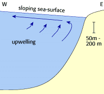

Schematic figures illustrating how a wind-driven current flowing
along the coast generates upwelling due to Ekman transport. These
figures were adapted from Ocean Circulation, by The Open University.
|
ACKNOWLEDGEMENT:
The animation of the Benguela upwelling zone was provided by Dr.
Derek Keats of the Botany Department of the University of the Western
Cape in South Africa.
 Chapter 3: The Galapagos plume
 Chapter 1: Interactions of ocean currents and biology around Tasmania
 Index: Classic CZCS scenes
|
|

![[animation]](https://webarchive.library.unt.edu/eot2008/20090513022704/http://daac.gsfc.nasa.gov/oceancolor/images/Benguela_upwelling.gif)