Malheur National Forest
| Grant County Chamber of Commerce | |
| Harney County Chamber of Commerce | |
| Evaluate Our Service We welcome your comments on our service and your suggestions for improvement |
Malheur National Forest (541) 575-3000 |
|
|
|
Points of Interest on the Malheur Forest
Cedar Grove Botanical Area|Vinegar Hill-Indian Rock Scenic Area|Magone Lake|Monument Rock Wilderness|Strawberry Mountain Wilderness CEDAR
GROVE BOTANICAL AREA
CEDAR
GROVE BOTANICAL AREA
The Cedar Grove Botanical Area in Eastern Oregon's Aldrich Mountains
covers about 26 acres and contains the only isolated stand of Alaska yellow
cedar east of the Cascades in the United States. This grove is located on the
northeast slope of Aldrich Mountain at the head of Buck Cabin Creek on the Blue
Mountain Ranger District. This species is normally found at scattered locations
in the Cascades and along the north Pacific coast. Experts believe that during
pre-glacial times in Oregon, the climate here was much cooler and more humid.
At that time, perhaps during the late Pleistocene, this stand may well have
been part of a contiguous stand of cedar. Because of the unique combination
of weather, moisture, and other conditions in this one isolated spot, this small
stand survived changes to hotter, drier weather. Most areas converted to ponderosa
pine and the other trees we see in eastern Oregon today. The cedar grove offers
a cool, welcome respite from the heat of a hot, desert-like summer day.
The cedar grove is located along a very wet area of springs and seeps and is
found amid a larger stand of true firs and Douglas-fir trees, along with some
ponderosa pine and western larch. Dark and cool, it is fairly open underneath
the trees, with not much undergrowth of shrubs and other vegetation. Some of
the current cedar trees are more than 300 years old. This stand has survived
fires in the past, and small cedar seedlings give promise to the continued existence
of this part of prehistoric Oregon.
You can find the Cedar Grove Botanical Area by driving south on Forest Service
Road 21 (Fields Creek Road) off of Highway 26, about 10 miles west of Mt.
Vernon.
When you reach Fields Creek summit, turn right and follow the Forest Service
Road 2150 for about five miles west to the trailhead. The trail is only
one mile
long.
It
crosses a broad ridge, then descends a timbered slope and ends in a short loop
through the grove of Alaska yellow cedars. The terrain is steep and rough
as
it passes through a dense fir forest and large rock outcroppings, giving it
the more difficult rating.
 VINEGAR
HILL-INDIAN ROCK SCENIC AREA
VINEGAR
HILL-INDIAN ROCK SCENIC AREA
Located in the northeast part of the Forest, this high elevation area provides
spectacular vistas of the North Fork John Day Wilderness, the Middle and North
Fork drainages of the John Day River, and the peaks of the Strawberry Mountain
Wilderness to the south. Nearly every type of alpine wildflower found west of
the Rockies can be blooming at different times in this area. Big game species
and upland game birds are common. There is a variety of geologic formations
including basalt, rhyloite, granite, and shales; rockhounders will find agate,
jasper, and quartz. The area has a rich history and active and decaying remains
of mines can be seen. The area provides unfettered opportunities for solitude
and isolation except during big-game hunting seasons.
To reach this wonderous area follow Highway 26 for approximately 26 miles,
turn right onto Highway 7, follow Highway 7 for about 1 mile, turn right onto
County
Road 20, continue on County Road 20 for about 11 miles, then turn onto Forest
Service Road 45, continue for apporximately 4 miles where you will reach the
boundary of this scenic area.
 MAGONE
LAKE
MAGONE
LAKE
Magone Lake, in the Malheur National Forest, about 26 miles
north of John Day, is one of Grant County's most popular lakes. Geologists
believe
the lake was creatd by a land slide in the early 1800's. Trees below the surface
still make non-motorized boating a bit hazardous. Angling for 8-to 15-inch
Eastern
Brook and Rainbow trout is consistently good. The U.S. Forest Service rebuilt
a 22-space campground, (handicap accessible), a boat ramp, and covered picnic
area near the lake a few years ago. This area offers swimming, hiking, fishing,
geology viewing, and wildflower viewing.
Magone Lake covers about 50 acres and features both deep holes (up to 100 feet)
and shoals on the north side. A hiking trail circles the lake.
To get to Magone Lake from the west or northwest, drive south on Highway 395
past Long Creek and turn left on Forest Road 36. The road leads east to the
lake. The other road access, (26 miles north of John Day) is from Highway
26 to County Road 18, then turn onto Forest Service Road 36, which leads to
the
lake.
A Malheur National Forest map would be helpful and can be found at Forest
Service offices in John Day and
Prairie City and at sporting goods stores.
For more information about road conditions, or to reserve the group campground
(it accommodates about 20 people and has room for motor homes or fifth-wheels)
or the picnic shelter, call the Prairie City Ranger District at (541) 820-3800.
There is drinking water, and each space features a picnic table, fire ring and
cooking grate. There is no electricity or garbage collection.
 MONUMENT
ROCK WILDERNESS
MONUMENT
ROCK WILDERNESS
At the southernmost edge of the Blue Mountains, this area's alpine, once-glaciated
ridges offer views across much of eastern Oregon. This Wilderness can be accessed
from Prairie City via County Road 20 and Forest Service Roads 13 and 1670.
The lichen-covered 8-foot cylindrical stone monument atop Monument Rock may
have
been erected
by
pioneer sheepherders. Established in 1984 by the Oregon Wilderness Act, the
19,620-acre Wilderness is located on the south end of the Malheur National
Forest
and is adjacent to the Wallowa-Whitman National Forest. The northern end of
the area lies across a watershed divide that separates drainages of the South
Fork
Burnt River, as well as two National Forests. The area ranges from about 5,200
feet in the lower regions to the 7,815-foot top of Table Rock.
In the lower lands you will find ponderosa pine, depending on where you go.
You may also find lodgepole pine, Douglas-fir, white fir, aspen, and juniper.
If you look down, you will probably see elk sedge, pinegrass, wheatgrass, huckleberry,
bluegrass, and many wildflowers. As you hike higher, you will find subalpine
fir, just below the treeless mountain crests.
The area's diverse wildlife habitat is used by bear, deer, elk, badgers, and
the rare wolverine. There are approximately 70 species of birds including the
creek-loving water ouzel (American dipper) and the pileated woodpecker.
The visiting season here generally runs between June and November. The John
Day Valley funnels winter storms and summer thundershowers to the mountain
ridges
here. As a result the area receives approximately 40 inches of annual precipitation,
twice as much as the surrounding, arid lowlands. Summer brings hot days and
chilly nights. Hunting is the most popular activity, with hiking and backpacking
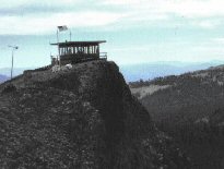
increasing in popularity. Table Rock Lookout draws many visitors and is one
of the entry
points to the Wilderness.
The fire lookout tower on Table Mountain is a good place to begin a visit to
the Monument Rock area. After taking in the view, backtrack a half mile down
the lookout road and take a level 2-mile stroll along an ancient dirt road to
Bullrun Rock's 150-foot cliffs. A fork of this trail winds close to Monument
Rock and continues 5 miles along a scenic ridgecrest to Lone Rock. To reach
the trailhead from Prairie City, turn south from Highway 26 on Main Street,
follow a paved road southeast 9 miles, turn left onto Road 13 for 12 miles,
then take Road 1370 to the left.
The Bullrun Creek Trail starts out with 2 easy miles of hiking in a steep-sided
canyon, but then climbs 2000 feet in 3.5 miles up a ridge to Bullrun Rock.
Drive
to the trailhead from Highway 26 by heading west from downtown Unity on a paved
road for 1 mile, then turning left onto gravel road for 4 miles. Turn to the
right on Forest Road 1695, then follow Forest Road 210 to the trail.
One of the more accessible and popular hikes climbs past Starvation Rock, a
large basalt monolith, to Forest Road 548 on the narrow ridge between Sheep
Rock and
Lookout Mountain. Backpackers and equestrians can use this path as a connector
between the Glacier-Monument and Strawberry Mountain trail systems, which
are
less than 2 miles apart here.
![[Photo] Picture of Strawberry Mountain](https://webarchive.library.unt.edu/eot2008/20090513053146im_/http://www.fs.fed.us/r6/malheur/images/mt-small-crop.jpg) STRAWBERRY
MOUNTAIN WILDERNESS
STRAWBERRY
MOUNTAIN WILDERNESS
The Strawberry Mountain Wilderness is located east of John Day, Oregon, in
the Malheur National Forest. The area includes approximately 68,700 acres
and
encompasses the headwaters of Pine, Indian, Strawberry, Canyon, Bear, Lake,
Wall, Roberts, and Big Creek. The area is dominated by the Strawberry Mountain
Range with the highest point being Strawberry Mountain, with the elevation
of 9,038 feet. This area has extremely diverse ecological makeup. Five of
the seven
major life zones in North America can be found here. It also supports native
population of Rocky Mountain Elk and other wildlife.
The complex geological story of this landscape began millions of years ago with
the buckling of an ancient sea floor beneath the area where the western part
of the Strawberry Range now rises. Much later, volcanic ash and lava formed
the eastern part of the range. Most recently, the glacial ice carved its classic
signature--U-shaped valleys--into the mountains. The ice also hollowed out the
rock beds that today hold the five alpine lakes of the Strawberry Mountain Wilderness--rare
pleasures in the arid wilderness experience.
In a normal year, most people use the Wilderness between July and November.
Snow may be encountered at higher elevations any time of the year. The climate
from September is mostly mild, with clear skies. Summertime thunderstorms may
occur, usually in cycles lasting several days. Daytime temperatures normally
range between 30 and 80 degrees Fahrenheit; nights are cool. Freezing temperatures
can occur any time of the year.
When you go to the Strawberry Mountain Wilderness, be prepared for hiking in
the high country. The land is rugged, and elevations range from 4,000 to the
9,038-foot summit of Strawberry Mountain. Over a hundred miles of trails cross
the wilderness, offering vista after vista to the enterprising hiker. In 1984,
the Oregon Wilderness Act more than doubled the original area of the Strawberry
Mountain Wilderness to its current total of 68,700 acres.
Water from springs, lakes, ponds, and streams should have proper treatment before
you drink it. No matter how pure it may look, surface water should be considered
unsafe to drink until properly treated. The most common disease associated with
surface water is giardiasis, caused by ingesting the microscopic parasite Giardia
lamblia. To be safe, boil or treat the water before drinking. The recommended
treatment is to bring water to a rolling boil for five minutes.
If you are patient, lucky, and observant, you may see many kinds of wildlife
in the wilderness. The list includes: elk, mule deer, antelope, black bear,
cougar, California bighorn sheep, ruffed and blue grouse, pileated woodpecker,
sharp-shinned hawk, bald eagle, pine marten, mink, beaver, and many more birds,
fur-bearing animals, and other creatures. In fact, around 378 kinds of animals
and approximately 22 fish species can be found in the area.
USDA Forest Service - Malheur National Forest
Last Modified: Tuesday, 19 February 2008 at 16:05:54 EST