
NOAA: April Temperatures Slightly Cooler Than Average for U.S.
May 8, 2009
The April 2009 temperature for the contiguous United States was below the long-term average, based on records going back to 1895, according to an analysis by NOAA’s National Climatic Data Center in Asheville, NC.
The average April temperature of 51.2 degrees F was 0.8 degree F below the 20th Century average. Precipitation across the contiguous United States in April averaged 2.62 inches, which is 0.19 inch above the 1901-2000 average.
U.S. Temperature Highlights
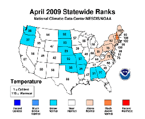
High resolution (Credit: NOAA)
- April temperatures were near normal across much of the United States. On a regional scale, only the Northeast (above-normal) and the West North Central (below-normal) deviated significantly from normal.
- New Hampshire observed its eighth warmest April, based on data going back to 1895. Unlike much of the Northeast, the Midwest experienced a cooler-than-normal month. From North Dakota southward to Oklahoma, Missouri, Louisiana, Alabama and Georgia, temperature averages were below normal.
- For the year-to-date period, only North Dakota and Washington have experienced notably cooler-than-normal average temperatures. In contrast, much of the South and Southwest regions were above normal. New Mexico had its ninth warmest such period on record.
- Based on NOAA's Residential Energy Demand Temperature Index, the contiguous U.S. temperature-related energy demand was 2.3 percent below average in April.
U.S. Precipitation Highlights
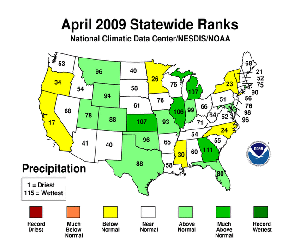
High resolution (Credit: NOAA)
- Above-normal precipitation fell across parts of the Central and South regions, while the West and Northwest regions experienced below-normal precipitation.
- Precipitation was above normal for the contiguous United States. Georgia had its fifth wettest April on record, Kansas and Michigan had their ninth wettest, and Illinois, its tenth. Only seven states were notably drier than normal for April.
- Year to date, the Northeast experienced its fourth driest January-through-April period on record and it was the twelfth driest period for the contiguous U.S.
- By the end of April, moderate-to-exceptional drought covered 18 percent of the contiguous United States, based on the U.S. Drought Monitor. Severe, or extreme, drought conditions continued in parts of California, Florida, Hawai'i, Nevada, Wisconsin, the southern Appalachians, and the southern Plains, with exceptional drought in southern Texas.
About 21 percent of the contiguous United States had moderately-to-extremely wet conditions at the end of April, according to the Palmer Index (a well-known index that measures both drought intensity and wet spell intensity).
Other Highlights
- International Falls, Minn., recorded 125 inches of snow so far this winter season, breaking the previous record of 116 inches set in the 1995-1996 winter season. Another seasonal snowfall record was broken in Spokane, Wash., where 97.7 inches of snowfall broke the old record of 93.5 inches set in 1915-1916.
- About eight percent of the contiguous U.S. was covered by snow at end of April, according to an analysis by the National Operational Hydrologic Remote Sensing Center. Snow coverage during the month peaked at 30.2 percent on April 6, after a late-season winter storm hit the Midwest and Plains.
- The 263 preliminary tornadoes reported in April was above the three-year average of 200 confirmed tornadoes.
NCDC’s preliminary reports, which assess the current state of the climate, are released soon after the end of each month. These analyses are based on preliminary data, which are subject to revision. Additional quality control is applied to the data when late reports are received several weeks after the end of the month and as increased scientific methods improve NCDC’s processing algorithms.
NOAA understands and predicts changes in the Earth's environment, from the depths of the ocean to the surface of the sun, and conserves and manages our coastal and marine resources.