
| Home | Bursts | Publications | Ops & Status | Goals | Team | History | Spacecraft | Instruments | Ground | Alerts | FAQ | Gallery |
Click on the following for more information!
The operational efficiency of the HETE spacecraft and instruments
has decreased due to the advanced age of the NiCd batteries on board.
This was to be expected after 6+ years of operations.
The spacecraft is still operational, but instrument operations
will be sporadic.
Currently, the HETE satellite's science
instrument fields-of-view map onto
the celestial sphere as shown below.
The distortion in the shape of the field-of-view is
due to the mapping of the celestial sphere onto a
azimuthal equal-area projection.
Because HETE is anti-solar pointing, its field-of view drifts along
the ecliptic at a rate of about one degree per day. However, due to
regular offsets from anti-solar to reduce contamination by moonlight
of the SXCs, the pointing of the HETE instruments can differ from
antisolar by up to 50 degrees.
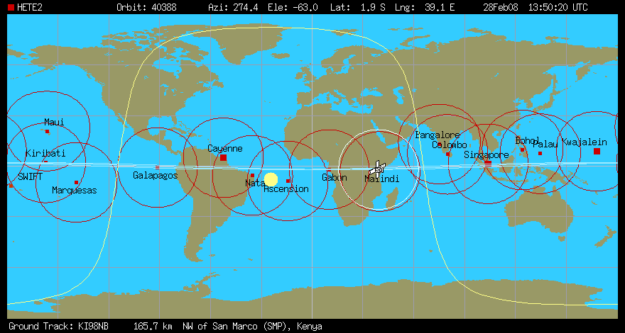
The map below shows the locations of the HETE
primary ground stations,
burst alert stations,
the orbit track of HETE, and the location
of the satellite at the time indicated in the upper-right-hand corner.
By clicking on the image, you can open a window which will update
the location of the HETE satellite every minute or so.
The red circles around each ground station indicate the range of
each station.
When the HETE satellite icon is within a circle, the satellite
is visible and audible to the ground station.
The wavy yellow line on the map is the terminator: the places on
the Earth where it is exactly sunset or sunrise. You can tell
which side of the line is day and which is night by looking for
the large yellow disk,
which indicates the sub-solar point, the point on
Earth where it is currently high noon.
The satellite icon will darken when it is in the Earth's shadow
(which is not when it crosses the terminator!).
Operations Updates
(Last update: Mar 28, 2007)
Operations Status
Back to top!
Where is HETE pointing?

Shown are the Fregate FOV (70 degrees radius) and the sensitive regions
of the SXC and WXM X and Y detectors (the X and Y detectors have slightly
different FOVs because of different levels of obstruction by the
mechanical supports of the instruments).
Back to top!
Where is HETE now?
(SatTrack is Copyright (c) 1992, 1993, 1994, 1995 by Manfred Bester.
All Rights Reserved.
See www.bester.com ).
Back to top!