
 Feeds & Data
Magnitude 6.6 - KURIL ISLANDS
2009 April 18 19:18:01 UTC
Earthquake Details
| Magnitude | 6.6 |
|---|---|
| Date-Time |
|
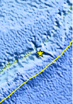
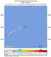
| Location | 46.061°N, 151.383°E |
| Depth | 57.1 km (35.5 miles) |
| Region | KURIL ISLANDS |
| Distances | 290 km (180 miles) ENE of Kuril'sk, Kuril Islands 625 km (390 miles) SW of Severo-Kuril'sk, Kuril Islands, Russia 1515 km (940 miles) NE of TOKYO, Japan 7155 km (4440 miles) NE of MOSCOW, Russia |
| Location Uncertainty | horizontal +/- 4.7 km (2.9 miles); depth +/- 8.9 km (5.5 miles) |
| Parameters | NST=309, Nph=309, Dmin=725.5 km, Rmss=0.87 sec, Gp= 32°, M-type=teleseismic moment magnitude (Mw), Version=Q |
| Source |
|
| Event ID | us2009fpb3 |
- This event has been reviewed by a seismologist.
- Did you feel it? Report shaking and damage at your location. You can also view a map displaying accumulated data from your report and others.
Earthquake Summary

Felt Reports
Recorded (3 JMA) in southeastern Hokkaido. Also recorded (1 JMA) in Aomori, Iwate and Miyagi, Honshu.
Earthquake Maps


Scientific & Technical Information

- Preliminary Earthquake Report
- U.S. Geological Survey, National Earthquake Information Center:
World Data Center for Seismology, Denver
