|
Use the pull down menu below to go to any of the El Niño/La Niña Watch pages.
Satellites confirm that El Niño is back and strong
September 15, 1997
Pacific Ocean sea-surface height measurements and
atmospheric water vapor information taken from two independent
Earth-orbiting satellites are providing more convincing evidence
that the weather-disrupting phenomenon known as El Niño is back.
"The new data collected since April 1997 confirm what we had
earlier speculated upon and what the National Oceanographic and
Atmospheric Administration has predicted - a full-blown El Niño
condition is established in the Pacific," said Dr. Lee-Lueng Fu,
project scientist for the U.S./French TOPEX/Poseidon satellite at
NASA's Jet Propulsion Laboratory, Pasadena, CA.
The five years of global ocean topography observations made
by TOPEX/Poseidon have been a boon for El Niño researchers, who
have been able to track three El Niño events since the
satellite's launch in August 1992.
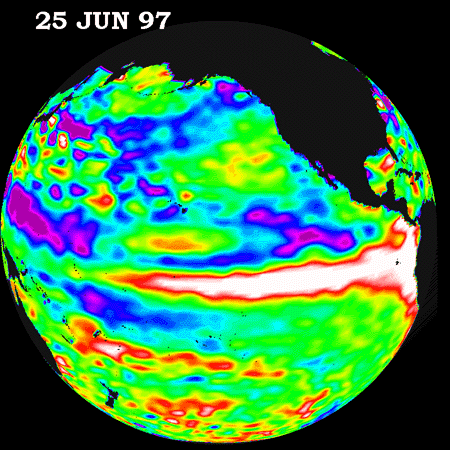
"The recent data are showing us that a large warm water mass
with high sea-surface elevations, about 15 centimeters (six
inches) above normal, is occupying the entire tropical Pacific
Ocean east of the international date line. In fact, the surface
area covered by the warm water mass is about one and a half times
the size of the continental United States," Fu said. "We watched
this warm water mass travel eastward from the western Pacific
along the equator earlier this spring. Right now, sea-surface
height off of the South American coast is 25 centimeters (10
inches) higher than normal, which is comparable with the
conditions during the so-called 'El Niño of the century' in 1982-83."
In addition, recent atmospheric water vapor data collected
from NASA's Upper Atmosphere Research Satellite (UARS) show tell-tale
signs of an El Niño condition in the tropical Pacific Ocean.
"The Microwave Limb Sounder experiment on UARS is detecting
an unusually large build-up of water vapor in the atmosphere at
heights of approximately 12 kilometers (eight miles) over the
central-eastern tropical Pacific. Not since the last strong El
Niño in the winter of 1991-92 have we seen such a large build-up
of water vapor in this part of the atmosphere," said JPL's Dr.
William Read. "Increased water vapor at these heights can be
associated with more intense winter-time storm activity from the
'pineapple express,' a pattern of atmospheric motions that brings
tropical moisture from Hawaii to the southwestern United States.
This phenomena is an example of how the ocean and atmosphere work
together to dictate the severity of El Niño events."
An El Niño is thought to be triggered when steady westward
blowing trade winds weaken and even reverse direction. This
change in the winds allows the large mass of warm water that is
normally located near Australia to move eastward along the
equator until it reaches the coast of South America. This
displaced pool of unusually warm water affects evaporation, where
rain clouds form and, consequently, alters the typical
atmospheric jet stream patterns around the world. The change in
the wind strength and direction also impacts global weather
patterns.
In May, the National Oceanographic and Atmospheric
Administration (NOAA) issued an advisory regarding the presence
of the early indications of El Niño conditions. Subsequent El
Niño forecast activities supported by NOAA indicate the
likelihood of a moderate or strong El Niño in late 1997. The
forecast model operated at NOAA's National Centers for
Environmental Prediction used data collected by the
TOPEX/Poseidon satellite.
"The added amount of oceanic warm water near the Americas,
with a temperature between 21-30 degrees Celsius (70-85 degrees
Fahrenheit), is about 30 times the volume of water in all the
U.S. Great Lakes combined," said Dr. Victor Zlotnicki, a
TOPEX/Poseidon investigator at JPL. "The difference between the
current, abnormally high amount of heat in the near-surface
waters and the usual amount of heat in the same area is about 93
times the total energy from fossil fuels consumed by the United
States in 1995."
Ongoing NOAA advisories on El Niño conditions are available
on the Internet at the following URL:
http://nic.fb4.noaa.gov:80/products/analysis_monitoring/ensostuff/
The climatic event has been given the name El Niño, a
Spanish term for a "boy child," because the warm current first
appeared off the coast of South America around Christmas. Past
El Niño events have often caused unusually heavy rain and
flooding in California, unseasonably mild winters in the Eastern
United States and severe droughts in Australia, Africa and
Indonesia. Better predictions of extreme climate episodes like
floods and droughts could save the United States billions of
dollars in damage costs. El Niño episodes usually occur
approximately every two to seven years.
Developed by NASA and the Centre National d'Etudes Spatiales
(CNES), the TOPEX/Poseidon satellite uses an altimeter to bounce
radar signals off the ocean's surface to get precise measurements
of the distance between the satellite and the sea surface. These
data are combined with measurements from other instruments that
pinpoint the satellite's exact location in space. Every 10 days,
scientists produce a complete map of global ocean topography,
the barely perceptible hills and valleys found on the sea
surface. With detailed knowledge of ocean topography, scientist
can then calculate the speed and direction of worldwide ocean
currents.
The MLS instrument was originally designed to study
atmospheric ozone depletion, but scientists have devised new ways
of using the data to study atmospheric water vapor. The UARS
satellite is completing its sixth year of operation after being
designed for only a two-year mission, and is conducting an
extended mission of longer-term global monitoring.
The Jet Propulsion Laboratory, a division of the California
Institute of Technology, Pasadena, CA, manages the TOPEX/Poseidon
mission and the MLS instrument for NASA's Mission to Planet Earth
enterprise, Washington, DC. The UARS satellite is managed by
NASA's Goddard Space Flight Center, Greenbelt, MD.
NASA's Mission to Planet Earth is a long-term science
research program designed to study the Earth's land, oceans, air,
ice and life as a total system.
For more information, please visit the TOPEX/Poseidon project
web page at
http://topex-www.jpl.nasa.gov/
|