|
|
|
Missions - SeaWinds on QuikSCAT
|
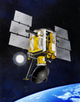
NASA's Quick Scatterometer (QuikSCAT) was lofted into space at 7:15 p.m. Pacific Daylight Time on Saturday
(6/19/99) atop a U.S. Air Force Titan II launch vehicle from Space Launch Complex 4 West at California's
Vandenberg Air Force Base. The satellite was launched in a south-southwesterly direction, soaring over the Pacific
Ocean at sunset as it ascended into space to achieve an initial elliptical orbit with a maximum altitude of about
800 kilometers (500 miles) above Earth's surface. Please check out the
Publications Section for frequent status reports and news.
 The SeaWinds on QuikSCAT mission is a "quick recovery" mission to fill the gap created by the loss of data from the NASA Scatterometer (NSCAT), when the satellite it was flying on lost power in June 1997. The SeaWinds instrument on the QuikSCAT satellite is a specialized microwave radar that measures near-surface wind speed and direction under all weather and cloud conditions over Earth's oceans.
 SeaWinds uses a rotating dish antenna with two spot beams that sweep in a circular pattern. The antenna radiates microwave pulses at a frequency of 13.4 gigahertz across broad regions on Earth's surface. The instrument will collect data over ocean, land, and ice in a continuous, 1,800-kilometer-wide band, making approximately 400,000 measurements and covering 90% of Earth's surface in one day.
Science Objectives
-
Acquire all-weather, high-resolution measurements of near-surface winds over global
oceans.
-
Determine atmospheric forcing, ocean response, and air-sea interaction mechanisms on various spatial and temporal scales.
-
Combine wind data with measurements from scientific instruments in other disciplines to help us better understand the mechanisms of global climate change and weather patterns.
-
Study both annual and semi-annual rain forest vegetation changes.
-
Study daily/seasonal sea ice edge movement and Arctic/Antarctic ice pack changes.
Operational Objectives
-
Improve weather forecasts near coastlines by using wind data in numerical weather- and wave-prediction
models.
-
Improve storm warning and monitoring.
Mission Description
-
Launch Vehicle: Titan II
-
Mission Life: 2 years (3 years consumables)
-
Orbit: Sun-synchronous, 803 km, 98.6° inclination orbit
Spacecraft
-
ADCS approach: 3-axis stabilized, Star Tracker/IRU/Reaction Wheels, C/A Code GPS
-
Pointing Acc.: < 0.1° absolute per axis
-
Pointing Knowl.: < 0.05° per axis
-
Telecom: (Science) 2 Mbps S-band P/L
(Hskp) 5, 16, 256 Kbps S-Band, 2 Kbps S-Band uplink
-
Propulsion: N2H4 Blowdown
-
Mass: 970 Kg
-
Orbital Avg Power: 874 W
-
Data Capacity: 8 Gbits
Ground Systems
-
Tracking by Earth Polar Ground stations Svalbard, Norway; Poker Flats, Alaska; Wallops Island,
Virginia; and McMurdo, Antarctica; Hatoyama, Japan (contingency station).
-
High-quality research data products produced at JPL and distributed to science community within 2 weeks of
receipt.
-
Scatterometer science data products are distributed through the JPL Physical Oceanography Distributed
Active Archive Center (PO.DAAC), a scientific data distribution site:
http://podaac.jpl.nasa.gov.
-
Operational data products produced at National Oceanic & Atmospheric Administration (NOAA) for
international meteorological community within 3 hours of data collection.
Instrument Description
-
Radar: 13.4 gigahertz; 110-watt pulse at 189-hertz pulse repetition frequency (PRF)
-
Antenna: 1-meter-diameter rotating dish that produces two spot beams, sweeping in a circular pattern
-
Mass: 200 kilograms
-
Power: 220 watts
-
Average Data Rate: 40 kilobits per second
Measurements
-
1,800-kilometer swath during each orbit provides approximately 90-percent coverage of Earth's oceans
every day.
-
Wind-speed measurements of 3 to 20 meters/second, with an accuracy of 2 meters/second; direction, with
an accuracy of 20 degrees.
-
Wind vector resolution of 25 kilometers.
Mission Partners
-
National Oceanic & Atmospheric Administration (NOAA)
-
NASA Goddard Space Flight Center (GSFC)
-
Ball Aerospace and Technologies Corporation
-
U.S. Air Force Space and Missile Systems Center
-
Honeywell Satellite Systems Operations
-
Raytheon E-Systems Corporation
-
Lockheed Martin Astronautics
-
Hughes Electron Dynamics Division
The SeaWinds/QuikSCAT project is managed for NASA's Earth Science Enterprise by the Jet Propulsion
Laboratory, a division of the California Institute of Technology.
|
 |
|