| Home >> | Advanced Search >> |
|
|
|
Astronaut Photography of Earth - Display Record
ISS019-E-6499

Low-resolution Browse Image
(Most browse images are not color adjusted.)Images
Conditions for Use of Images >>Image Transformation Tutorial >> Saving, Color Adjusting, and Printing Images >>
Images to View on Your Computer Now
| File Name | File Size (bytes) | Width | Height | Annotated | Cropped | Purpose | Comments | |
|---|---|---|---|---|---|---|---|---|
| View | ISS019-E-6499.JPG | 98339 | 640 | 438 | No | No | ||
| View | ISS019-E-6499.JPG | 309557 | 540 | 328 | Yes | Yes | NASA's Earth Observatory web site |
Large Images to Request for Downloading
| File Name | File Size (bytes) | Width | Height | Annotated | Cropped | Purpose | Comments | |
|---|---|---|---|---|---|---|---|---|
| Request | ISS019-E-6499.JPG | 1048564 | 1000 | 608 | No | Yes | NASA's Earth Observatory web site | |
| Request | ISS019-E-6499.JPG | 1929042 | 4256 | 2913 | No | No |
Download a Keyhole Markup Language (KML) file for use in Google Earth.
Electronic Image Data
Camera Files >> No sound file available.Identification
Mission: ISS019 Roll: E Frame: 6499 Mission ID on the Film or image: ISS019Country or Geographic Name: TURKEY
Features: ANKARA, ROADS, HILLS
Center Point Latitude: 39.9 Center Point Longitude: 32.9 (Negative numbers indicate south for latitude and west for longitude)
Stereo: (Yes indicates there is an adjacent picture of the same area)
ONC Map ID: JNC Map ID:
Camera
Camera Tilt: 13Camera Focal Length: 400mm
Camera: N2: Nikon D2Xs
Film: 4288E : 4288 x 2848 pixel CMOS sensor, RGBG imager color filter.
Quality
Film Exposure:Percentage of Cloud Cover: 10 (0-10)
Nadir
Date: 20090411 (YYYYMMDD)GMT Time: 130118 (HHMMSS)Nadir Point Latitude: 39.3, Longitude: 33.3 (Negative numbers indicate south for latitude and west for longitude)
Nadir to Photo Center Direction: Northwest
Sun Azimuth: 248 (Clockwise angle in degrees from north to the sun measured at the nadir point)
Spacecraft Altitude: 188 nautical miles (348 km)
Sun Elevation Angle: 37 (Angle in degrees between the horizon and the sun, measured at the nadir point)
Orbit Number: 3546
Captions
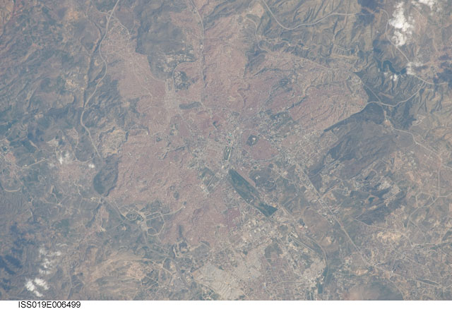
Ankara, TurkeyThe central portion of the capital city of Turkey, Ankara, is featured in this astronaut photograph. Ankara is located in central Turkey. The climate there is continental and relatively dry, leading to cold winters and hot summers. The region is prone to major earthquakes, as Turkey experiences tectonic forces from both the African plate to the west and the Arabian plate to the east. Despite the earthquake hazard, the city traces its roots back into antiquity, with a Hittite settlement here prior to 1200 BC. A citadel built and occupied in turn by the Galatians, Romans, Byzantines, and Seljuks overlooks the central portion of the city, and today serves as both a historical and recreational site. Perhaps an even more imposing structure—the mausoleum of the founder of the modern-day Republic of Turkey, Mustafa Kemal Atatürk—is visible on an adjacent hill to the southwest.
Hill slopes around the city (image left and right) are fairly green due to spring rainfall. One of the most striking aspects of the urban area is the almost uniform use of red brick roofing tiles, which contrast with lighter-colored roads; the contrast is particularly evident in the northern (image lower left) and southern (image upper right) portions of the city. Numerous parks are visible as green patches interspersed within the red-roofed urban region. A region of cultivated fields in the western portion of the city (image center) is a recreational farming area known as the Atatürk Forest Farm and Zoo—an interesting example of intentional preservation of a former land use within an urban area.
Download Packaged File.
This option downloads the following items, packaged into a single file, if they are available:
- Browse image
- Cataloged information with captions
- Camera file
- Sound file
Server: 2 |
This service is provided by the International Space Station program. |
Recommended Citation: |
||

