Severe Weather
and Wind Event - April 15, 2007
Write-up by Melissa Hurlbut and Scott Carroll
Baker County survey by Steve Letro, Pete Wolf, and Scott Carroll
Introduction
On April 15, 2007, a deep low pressure center created
conditions that
led to severe weather including two tornado reports, several damaging
wind reports, and very windy conditions ahead of and following the cold
front. The strong winds associated with the strong low
produced additional damage and sporadic power outages across much of
the area.
Synoptic Situation
In the early morning hours of April 15, 2007, a deepening
low pressure
center moved across the Southeast United States. Northeast
Florida and
Southeast Georgia were located in the warm sector of this system (Image
1).
A pre-frontal squall line developed ahead of a cold front as
it moved eastward. Temperatures in the lower 70's and dew points in the
upper 60's,
along with large scale lift due to the frontal system itself, supported
thunderstorm development. A low level jet and strong deep layer shear
were conducive for damaging winds, as well as rotating
thunderstorms.
The
Storm Prediction Center (SPC) had indicated that roughly the
northwestern half of the Jacksonville county warning area was under a
moderate risk of severe weather, with the remainder of the region under
a slight risk (Image 2).

Image
1: Surface weather map 7am April 15, 2007 |

Image
2: SPC Day 1 Convective Outlook 853pm April 14, 2007 |
Products Issued by NWS Jacksonville
| Area Forecast Discussions |
Hazardous Weather
Outlooks |
Warnings &
Statements |
4/10/07
at 233pm
4/11/07
at 310am
4/11/07
at 257pm
4/12/07
at 326am
4/12/07
at 253pm
4/13/07
at 315am
4/13/07
at 1001am
4/13/07
at 251pm
4/13/07
at 837pm
4/14/07
at 317am
4/14/07
at 942am
4/14/07
at 258pm
4/14/07
at 854pm
4/15/07
at 349am
4/15/07
at 1139am
4/15/07
at 217pm |
4/11/07
at 451am
4/11/07
at 609pm
4/12/07
at 358am
4/13/07
at 344am
4/14/07
at 344am
4/14/07
at 445pm
4/14/07
at 1009pm
4/15/07
at 1200am
4/15/07
at 622am
4/15/07
at 909am
4/15/07
at 1118am
4/15/07
at 1015pm |
Severe
Thunderstorm Warnings
700am:
N Baker, Charlton, SE Ware, NW Nassau
819am:
SE Bradford, Clay
824am:
Duval
930am:
E Putnam
952am:
S St. Johns
Tornado Warnings
713am:
S Charlton, NW Nassau
752am:
Alachua
1008am:
SE St. Johns
Severe
Weather Statements
728am:
N Baker, Charlton, SE Ware, NW Nassau
759am:
S Charlton, NW Nassau
830am:
Alachua
857am:
SE Bradford, Clay
857am:
Duval
1004am:
SE St. Johns
1018am:
S St. Johns
1020am:
SE St. Johns
|
| Event
Storm Report Summary |
Wind/ Lake Wind
Advisories |
4/14/07
at 245pm
4/14/07
at 756pm
4/15/07
at 1254pm
4/15/07
at 237pm
4/15/07
at 905pm |
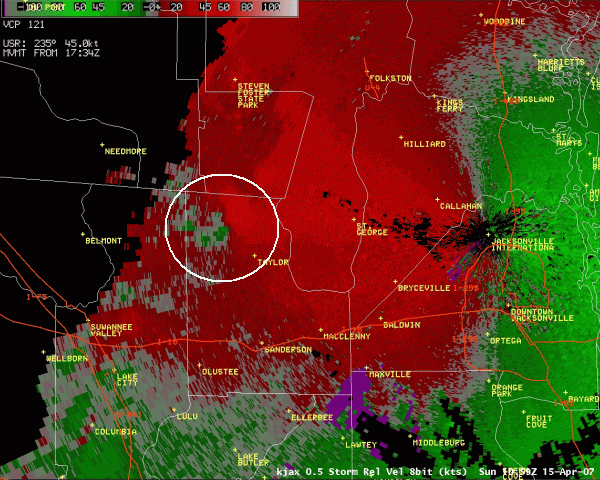
Radar Imagery - Baker County EF2 Tornado
 |
 |
 |
| 0.5° reflectivity loop with warning polygons overlaid (744 Kb) |
0.5° base velocity loop showing strong inbound velocity and initial convergent flow (814 Kb) |
0.5° storm relative velocity loop showing tight circulation (869 Kb) |
 |
 |
|
| 2.4° reflectivity loop showing bounded weak echo region (BWER) (1.03 Mb) |
5 minute lightning loop (117 Kb) |
|
Damage Survey - Baker County EF2 Tornado
 NWS
Jacksonville conducted a storm survey of damage in extreme northeastern
Baker county about 7 mile north northeast of Taylor (damage path map to
left). We confirmed that the damage was in fact due to an EF2
tornado (Enhanced Fujita Scale).
Radar imagery of this event is depicted above in the radar imagery
section. The path started in a dense wooded area about one
quarter of a mile southwest of the southern leg of Moccasin Creek
Circle, cut a path across farmland off of Lacy Crews Road, the
ended about one quarter of a mile northeast of the northern leg of
Moccasin Creek Circle in more dense woods. The approximate length
of the path was 1.5 miles and the approximate width of the path was 300
yards.
Numerous
trees were snapped, both in the wooded areas surrounding the farmland
and in several patches of trees on the property. Several large
oak trees were uprooted as well. Evidence of the tornado
vortex was found along the path. Additionally, bark was partially
stripped from several trees. Two out buildings north northeast of
the residence were completely destroyed. This was very weak
construction, and the home on the property only suffered minor damage.
However, a large branch was blown into the side of a
screened porch. A few pieces of metal roofing material from the
out buildings was found in the woods on the northeast end of the
property wrapped around trees.
Some
of the digital photos taken on the survey are linked to the thumbnails
below. Descriptions of the photos will appear once your mouse is
placed over the thumbnail. Pictures range from 133 Kb to 411 Kb
in size.
NWS
Jacksonville conducted a storm survey of damage in extreme northeastern
Baker county about 7 mile north northeast of Taylor (damage path map to
left). We confirmed that the damage was in fact due to an EF2
tornado (Enhanced Fujita Scale).
Radar imagery of this event is depicted above in the radar imagery
section. The path started in a dense wooded area about one
quarter of a mile southwest of the southern leg of Moccasin Creek
Circle, cut a path across farmland off of Lacy Crews Road, the
ended about one quarter of a mile northeast of the northern leg of
Moccasin Creek Circle in more dense woods. The approximate length
of the path was 1.5 miles and the approximate width of the path was 300
yards.
Numerous
trees were snapped, both in the wooded areas surrounding the farmland
and in several patches of trees on the property. Several large
oak trees were uprooted as well. Evidence of the tornado
vortex was found along the path. Additionally, bark was partially
stripped from several trees. Two out buildings north northeast of
the residence were completely destroyed. This was very weak
construction, and the home on the property only suffered minor damage.
However, a large branch was blown into the side of a
screened porch. A few pieces of metal roofing material from the
out buildings was found in the woods on the northeast end of the
property wrapped around trees.
Some
of the digital photos taken on the survey are linked to the thumbnails
below. Descriptions of the photos will appear once your mouse is
placed over the thumbnail. Pictures range from 133 Kb to 411 Kb
in size.


Strong
Winds
The deep low pressure center that
influenced
severe weather across the Southeast also generated very windy
conditions due to a tight pressure gradient. The last April event on
record with extended sustained winds of greater than 20 mph was April
of 2001, making this a somewhat rare event. Numerous downed trees and
power outages were reported on the 15th of April. Peak wind speeds at
local automated surface observation systems were as follows:
Jacksonville,
FL: West
at 45 mph
Gainesville, FL: Northwest at 39 mph
Alma,
GA: South at 43 mph
Saint
Simons Island, GA: West at 46 mph