| Planning | |
| Scenario Planning | |
SummaryThe following report summarizes a Peer Workshop on tools and effective practices for scenario planning. The Federal Highway Administration (FHWA) coordinated and led the daylong workshop in Frankfort, Kentucky. Presenters from the FHWA provided participants with an overview of the scenario planning process and described available resources and tools to assist with scenario planning analysis. Members of metropolitan planning organization (MPO) and area development district (ADD) staffs joined members of the Kentucky Transportation Cabinet staff for a one-day scenario planning workshop in Frankfort, Kentucky. Attendees hailed from across the state and shared their regional perspectives on introducing scenario planning to their planning processes. Presenters from Renaissance Planning Group, the North Central Florida Regional Planning Council, and the University of Kentucky provided the group with information on implementing scenario planning in a variety of community contexts.I. WelcomeA. Marc Williams, Commissioner of Highways, Kentucky Transportation CabinetMr. Williams welcomed the group and thanked KYTC and FHWA staff for putting together the program. He noted that it is important to implement these types of planning capability and technologies to evaluate options and educate citizens and policy makers on the transportation system scenarios. The State of Kentucky faces two critical future scenarios: insufficient transportation funding and insufficient political will to carry out planned improvements. In 2006, transportation spending in Kentucky exceeded a billion dollars. This cannot be sustained under current funding formulae. The State will need to be prepared to take a different approach with citizens and developers who want to see highway improvements. While the State has a responsibility for the highway program and needs to be able to implement needed changes, it is important to be realistic about funding prospects. The second scenario is the political environment. For example, planning studies that fall short in implementation indicate a lack of real political support. This needs to be understood early in the planning process. Project advocates tend to be involved early on, but a wider range of players become involved in implementation. Planners tend to be optimists and believe that "if we come up with a good plan, we will solve the problem", but it is important to keep a bit of pessimistic reality in the back of your mind. B. Denis Luhrs, Assistant Division Administrator, Federal Highway Administration Kentucky Division OfficeMr. Luhrs welcomed the group on behalf of FHWA. He recounted an experience he had working with middle school students as an engineer mentor for the National Engineers' Week Future City Competition. The Kentucky Division Office worked with the students to design a city using Sim City 3000. In the process, the need for more such citizen education about transportation and planning became evident.
II. IntroductionA. Overview of Scenario PlanningJody McCullough, Community Planner, Federal Highway Administration Office of Planning Ms. McCullough provided the group with an overview of scenario planning and how it could be used for a more effective transportation planning process. FHWA believes scenario planning to be an effective method for thinking about planning broadly. It can be used to bring together transportation and land use, to bring the public to the table, and to enable better interaction by allowing participants to learn from each other and through new tools and technologies. Visualization techniques help the public understand how the transportation decisions interact with what the land use development community is doing. FHWA defines scenario planning as "a process in which transportation professionals and citizens work together to analyze and shape the long-term future of their communities. Using a variety of tools and techniques, participants assess trends in key factors such as transportation, land use, demographics, health, etc. Participants bring the factors together in alternative future scenarios, each of these reflecting different trend assumptions and tradeoff preferences." Queensland, Australia, an early proponent of scenario planning for transportation and land use, laid out the following process:
Scenario planning is not a prediction, but rather a method to identify best and worst case scenarios and develop alternatives so that a community is not blindsided by change. Existing conditions, trends, and driving forces are used to create the scenarios. Communities can get creative in developing the scenarios, not all of which have to be reasonable. Extreme scenarios may not be chosen ultimately, but are useful for moving the discussion forward. After picking scenarios, communities come up with goals and policies to implement them. Benefits of Scenario Planning:
The process becomes more transparent to the public by including them in it. The public may not make the final decision, but they better understand the tradeoffs and why the decisions were made the way they were. Communities are finding that scenario planning enables a healthy public involvement process, where members of the public feel that their voices are being heard and public involvement is more than an empty exercise. The tools allow you to analyze complex data effectively, looking at natural resources, land cover, and many other types of information. When you bring the community, you can better clarify their preexisting misconceptions before the decisionmaking occurs. Having a map and pictures of typical development types helps everyone to understand what is being discussed and to alleviate the use of technical jargon. The community can provide real-time input and see real-time results. Participation becomes much broader than in the past. Scenario planning is often used in high-growth communities experiencing new development pressures, but is also helpful in communities that are growing slowly or even losing population. Binghamton, NY is a no-growth area, losing industries with an aging population. However, community resources include a university and good quality of life. Scenario planning was used to as a tool to sustain quality of life, identify new directions, and determine how to allocate resources most efficiently instead of continuing along the current path. The Federal role in scenario planning is essentially that of capacity building and providing technical assistance. The FHWA Scenario Planning website provides information on tools, technologies, and case studies from across the country. No additional funding for implementing scenario planning, as it is an enhancement to the existing process. While it does require additional up-front resources, it can reduce the chance of running into unforeseen obstacles further down the road.
III. Local Trends and Planning EffortsA. Presentation: Importance of Scenario Planning LocallyDaryl Greer, Director, Division of Planning, Kentucky Transportation Cabinet Current issues include:
Demographic Trends:
Data Sources: B. Breakout Session IIn the first breakout discussion section, participants focused on their existing processes and what they would like to learn about scenario planning. Participants were divided into four groups to discuss the questions below and reassembled to report out on their small group discussions.
Discussion Questions:
Question 1: What would you like to do to improve your planning process?
Question 2: What are trends that have gained importance?
Question 3: What would you like to learn about Scenario Planning today?
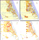
IV. Peer Practices and ObservationsA. Regional Scenario PlanningKate Ange, Principal Planner, Renaissance Planning Group, Orlando, Florida Ms. Ange is a principal planner with Renaissance Planning Group, Inc., a planning, design, and policy analysis consulting firm specializing in the integration of transportation, land use, urban design, and technology. The firm provides services primarily to public sector agencies, including metropolitan planning organizations, regional planning commissions, local governments, transit authorities, and state and federal agencies. As part of its work, Renaissance has undertaken scenario planning in Charlottesville, Virginia; Binghamton, New York; Birmingham, Alabama; Waco, Texas and Martin-St. Lucie Counties, Florida, which Ms. Ange focused on in her presentation. Scenario planning is essentially a tool for getting to the "what ifs". Planning is a long-term process, and today's trends may not reflect the future reality or opportunities. Scenario planning gives communities a process to explore alternate possible futures. It also allows a community to understand the tradeoffs associated with different scenarios and make better informed policy decisions. Finally, when transportation agencies talk about placemaking, it changes the context of the discussion and "reframes" the key issues. It allows the community to more effectively approach the transportation, land use and urban design connection. Transportation planners may not be comfortable with talking about urban design, but it is critical to do so, as the built form lays the foundation for transportation choices by enabling walking and bicycle trips and contributing to the possibilities for transit. Scenario Planning Process: Step 1: Values Framework. The process begins with setting the values framework. The scenarios could be driven purely by cost considerations, by open space preservation, or by other identified values. Step 2: Develop Alternatives. Alternatives development begins with an examination of the current trends, and is followed by community placemaking exercises that ask what kind of future growth should occur, and where should growth go or not go? The public can engage on these questions at a community design level, without any special training. The exercise is an effective way to help the public understand the connection between land use and transportation choices. Step 3: Evaluate Alternatives. With 3 or 4 alternatives in place, the community can compare tradeoffs, illustrate extremes, and highlight the relationship between development decisions and transportation policy options.. Step 4: Implement Preferences. If the preferred scenario is different than the "trend" scenario, implementation will have to start with the policy framework. While there can be friction with the land use community, MPOs do prioritize funding that can be used as a carrot or stick to further the implementation of a preferred alternative. Land use planners should be involved as early as possible in the process, so that they take ownership, and gain insight into the impacts of their decisions on transportation. Another critical implementation component is identifying "vision keepers", who can help move implementation forward over the long term. From these exercises, a palette of enhanced place types was developed and presented back to the public at a second series of public workshops. During these workshops participants played the "dot-map game" which empowered the group to decide where the different place types should go across the two-county region. After going through the process, the public also began to identify logical transportation investments. Based on the input from the workshops, Renaissance builds alternative scenarios by using the CorPlan land use allocation model, which incorporates preferred and use patterns. The end result is a composite map representing different development densities with varying uses representing employment and residential. The CorPlan model is based on an excel spreadsheet where you can input floor-area-ratios, residents per square foot, many other elements to create the model on a regional scale. Once the land use scenarios are developed, a set of socio-economic data (zdata) is created for each scenario that is then exported into the transportation demand model to determine mobility needs. By modeling the alternatives, the transportation infrastructure impacts, such as vehicle miles traveled, jobs-housing balance, or the number of people who can walk to amenities can be compared. The land use and transportation alternatives are then presented to the community and compared to previously-identified performance measures. The public then identifies a preferred alternative or a hybrid. In this case, four scenarios were presented to the public, the "buildout" which looked at the trend of existing development patterns, , the "trend", based on existing comprehensive plans, and two alternatives: "contained edge" with an emphasis on existing city centers and premium rail, and "western parkway" with new urban centers and other premium transit. One of the interesting outcomes of this analysis is that while Florida has strong comprehensive planning requirements, the actual development that occurs is often at lower densities and intensities than is allowed, thus can create false expectations as to how future growth can actually be accommodated and mobility needs overtime. Showing this to the public visually can help them to understand where the trends are likely to lead the region and serves as an effective visualization tool.
At the conclusion of the scenario planning process, the Joint MPO Boards decided to endorse the Western Parkway Scenario as a vision only. Ultimately, the MPO Policy Board was not empowered to adopt a radically different long range plan that was inconsistent with local comprehensive plans. Consequently, the trend LRTP plan was maintained. However, since then, the MPO has begun drafting policies that support the major design concepts and mobility options associated with the alternative scenario. In addition, the entire process has elevated the discussion locally engaging land use planners in the transportation issues. Lessons Learned
Discussion: Q: Do you think that if the local planners had been involved, an alternative would have been adopted? Q: How do you get the people to the table? Also, how do you broaden participation while encouraging consistent participation? Q: Did the public choose an alternative? Were land use agencies open to the idea? Q: If the public chooses differently than the policy board, will they question the value of their involvement? Q: How can we get the land use planners involved when we're on different plan update cycles? Q: How much educational component is there to the workshops? Q: How did you determine the transportation impacts of the alternatives? Q: What was the sequence of events that brought you in? Is scenario planning usually driven by an event? B. What is Scenario Planning?Marlie Sanderson, Director of Transportation Planning, North Central Florida Regional Planning Council (NCFRPC), Gainesville, Florida NCFRPC represents 11 counties in north central Florida. The area is rural, with the exception of Gainesville. Mr. Sanderson presented the NCFRPC's experience with scenario planning for its last long-range plan update. Predominantly, MPOs are leading scenario planning, although local governments, states, and even universities may be involved. In Gainesville, both city and county commissioners are the voting members of the MPO policy board. This is an unusual setup for Florida, but helpful for the commissioners in understanding the connection between transportation and land use decisionmaking. The impetus for scenario planning came from the county commissioners. The process that NCFRPC used is less reliant on computer modeling than many others, although they also worked with the Renaissance Planning Group. Mr. Sanderson discussed the "Rip Van Winkle Technique," which asks participants, "what do you want your community to look like in 20 years?" They developed four land use scenarios, including the existing trend, westward growth; a compact area concept; an activity center or "town and village" concept; and radial development, which focused on State Road 24 as a predominant spoke of the wheel and had a focus for higher levels of bus service. Each scenario was evaluated on different measures (through the model), such as the percent of the population and of jobs served by transit and the amount of new land consumed. There was interest in light rail, but it is not likely to happen soon. One outcome of the plan was a focus on bus rapid transit. Students pay a transportation fee and get a free bus pass, which boosts bus ridership. The county commissioners ultimately created a hybrid scenario incorporating their favorite elements of the scenarios. An urban services line was created to add an incentive to develop in the preferred area. Florida is progressive with growth management and there are strong state incentives and pressures to innovate. Lessons learned
Urban Village Action Plan A current initiative is the Urban Village Action Plan, which focuses on the area adjacent to the University of Florida. It is a unique location with a strong retail base. The hope is to concentrate students, faculty, staff, and young professionals in an area with strong pedestrian and bicycle infrastructure and a high level of transit service. The goal is to increase density in the future and create more transportation choices to university and hospitals. The MPO worked with architecture students to find ways to achieve that vision. Discussion:
Q: What is the scale of the Urban Village area? Q: Do your four scenarios include the "trend" scenario? Q: Was there significant media coverage? Q: What is the student population? Q: How do you implement scenario planning with limited resources?
V. ImplementationA. Local Presentation: Structured Public Involvement in Public Infrastructure Planning and Design Dr. Ted Grossardt, University of Kentucky Transportation Research Center Dr. Grossardt spoke on the structured public involvement projects the University of Kentucky Transportation Research Center has undertaken, featuring one from Jeffersonville, Indiana.
In his research, Dr. Grossardt has found that the public would like to be more involved in the project development process. Arnstein's ladder of public participation (Fig 4) shows the range of possible stages of public involvement. Using keypad voting, the team asked the public and professionals where the public is now on the scale and then where they should be. Opinions differed on the existing condition, but the public and the professionals both believe should be in the same place: partnership. There are three components of structured public involvement: representation, group dialogic methods, and decision modeling. For Jeffersonville, Indiana the team developed 12 sample development patterns using GIS and community VIZ. The samples are ranked according to mix of housing types, mix of land uses, open space, non-auto network, network connectivity, and population density. Each scenario represents about 100 acres. The samples are presented to the public as a flythrough animation created from the 3D model using CommunityViz. Densities are relative and adapted to the context, so that "high density" does not mean "Manhattan". Participants are not shown actual places, because the team wants them to have more abstract opinions which are dissociated from their particular street. Using this "veil of ignorance" makes them "behave like citizens". Using structured public involvement and keypad voting, the public can rate the samples and choose which are most suitable for their community. The system can handle up to 250 participants. In this case, there were approximately 100 participants in 2 meetings. The team uses fuzzy set math to deal with non-linear systems and sparse data. While participants only voted on 5% of the combinations, using fuzzy set math preferences the other 95% can be modeled. The modeled preferences for combinations of design properties create a decision support tool to help the public tell decisionmakers what they like. Discussion:
Q: Is there much difference between communities? Q: What about project prioritization in the region? Q: What you're showing is a tool that validates that people know what they like but they don't know how to articulate what that is or why. Q: How do you get people to the activity in the first place? We have the same people with the same agenda over and over. B: Local Presentation: Land Use Planning and Modeling Landscape ChangeBrian Lee, Department of Landscape Architecture, College of Agriculture, University of Kentucky Landscape architecture students participate in the County Land Use Planning Studio, a one-semester planning project. The studio is invited by a community, which must present both a good learning experience for the students and an opportunity to generate good ideas for the community. There is generally a lead time of 1-2 years, but the process can happen more quickly. More than 20 projects have been conducted since 1987. This semester, the studio is set in Owen County. Landscape architecture is both an art and a science. The students develop scenarios based on theme words. Keypad voting, which allows for up to 1000 participants at one time, is used to allow real-time rankings. The students modeled riparian areas, watersheds, cultural amenities, species protection, agricultural land, and other factors, and layered them to identify preferred growth areas. The products are maps, boards, and summary reports. Out of this process, new attention was focused on "hotspot" growth areas which were previously not identified. Modeling Landscape Change Pilot This is a much larger scale project, which uses data from the state Office of Geographic Information Systems. SLEUTH (slope, land cover, exclusion, urbanization, transportation, hillshade), is a project sponsored by USGS and the National Science Foundation and pilot projects are taking place around the country. Discussion: Q: Can you flip the "exclusionary" modeling to promote development in the urbanized area, so that development doesn't leapfrog? C. Breakout Session 2During the second breakout session, participants focused on scenario planning implementation. Participants were interested in scenario planning, and saw many opportunities to make use of existing resources and processes. However, there were concerns about creating friction with the land use community and getting the public to understand scenario planning's value in low or no-growth areas. Discussion Questions:
Question 1: How would Scenario Planning benefit your region?
Question 2: What challenges will you need to overcome to implement Scenario Planning?
Question 3: What tools, resources, or activities do you currently have available to do Scenario Planning?
D. Presentation: Scenario Planning ToolsJim Thorne, Metropolitan Planning Specialist, FHWA Resource Center Mr. Thorne presented a range of scenario planning tools and resources. He recommended that participants begin by figuring out what they are trying to accomplish and then select the tools best suited to get the job done. Scenario Planning Tools are a means to an end, which is to say that they exist to accomplish some other activity and are not the answer in and of themselves. There have been innovations over the years that have enhanced the planning tools that are available, but lower technology, simpler methods also have their place in this process. Basic steps in the scenario planning process were reviewed and participants identified tools that could help in each step. For example, tools to engage the community could include public meetings, participation in other community events, group facilitation skills, visualization, the chip game, web sites, Geographic Information Systems and other software such as Corplan or CommunityViz. FHWA does not recommend one software package over another; the choice of software will depend on the user's resources and needs. Many websites have resources to help identify the appropriate tools for various planning activities. Technology has come a long way, but there are low-tech tools that can be very effective at getting people engaged in the process. Reference was made to the public participation spectrum developed by the International Association of Public Participation which can be used to identify specific goals for public participation (inform, consult, involve, collaborate, empower) and then selecting approaches and tools to meet those goals. Scenario Planning tools are used to engage the community. Resources include census data, historical records, geographic information systems and the public itself. Scenarios can be developed by using a wide range of tools, including traffic forecast models, strings and ribbons, chip games, GIS, or one of the specialized software packages. Information and examples were provided in the following categories:
Tips:
Discussion:
Q: With no budget, could you recommend a place to start? Universities can be a great resource in these planning efforts. Many planning agencies have formed ongoing relationships with universities in their community to take advantage of the resources they have to offer. This also provides real work experience for university students. The University of Kentucky has interns at KYTC and could also work with other units of government.
VI. For More Information
VII. List of Presenters
To provide Feedback, Suggestions or Comments for this page, contact Frederick Bowers (frederick.bowers@dot.gov). |