HOME | ABOUT US | CONTACT | REGIONAL MANAGERS

Nautical Charts & Publications
Navigator with compass in hand working on paper nautical chart with Weems parallel plotter; Coast Pilot 6 publication off to side.

NOAA produces and maintains a suite of nautical charts that cover the coastal waters of the U.S. and its territories. NOAA’s charts are available in a variety of formats, including:

  • Traditional paper charts
  • Print-on-Demand charts: up-to-date paper charts with current Notice to Mariners corrections
  • Raster Navigational Charts® (NOAA RNCs): bitmap electronic images of paper charts
  • Electronic Navigational Charts® (NOAA ENCs): vector charts that conform to international standards

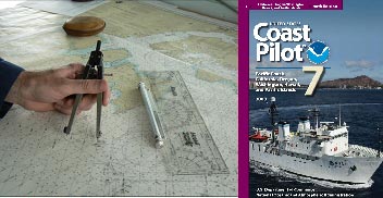
NOAA also produces several nautical publications. For example, the United States Coast Pilot® is a series of nautical books with a variety of important information for navigators to supplement the nautical chart.

Nautical Charts & Products
   •  Traditional Paper Charts
   •  Print-on-Demand Charts (POD)
   •  Raster Navigational Charts: NOAA RNCs®
   •  Electronic Navigational Charts: NOAA ENCs®
   •  PocketCharts
   •  BookletChart™ (Experimental)
   •  Chart Updates (LNM and NM Corrections)
Nautical Charting Publications
   •  United States Coast Pilot®
   •  U.S. Chart No. 1
   •  Chart Catalogs
   •  Dates of Latest Editions (DOLE)
   •  Upcoming New Editions (SON)
Nautical Charting Utilities
   •  NOAA's On-Line Chart Viewer
Historical Products
   •  Historical Maps and Charts
   •  Historical Coast Pilots
Learn About Charting Products
   •  Obtain Charting Products
   •  How a Chart is Updated
   •  Differences Between Maps & Charts
   •  Learn About Nautical Charts
   •  DGPS & Your Chart
   •  Differences Between NM and LNM
   •  Differences Between RNCs and ENCs
   •  Differences Between NOAA ENCs® and DNCs®
   •  Differences Between ENC and ENC®Direct to GIS
Data Portals
   •  Tides and Currents (General)
   •  nowCOAST: Real-Time Coastal Data Map Portal
   •  Physical Oceanographic Real-Time System (PORTS)
   •  Nautical Charting Links
Resources
   •  Coast Survey Partners
   •  Chart Carriage Requirements
   •  Report a Charting Discrepancy
   •  Chart Inquiries (questions/comments)
   •  Cartographic Automation
   •  Nautical Chart Calendars
 

Privacy Policy  |  Disclaimer  |  NOAA's National Ocean Service  |  NOAA  |  U.S. Department of Commerce