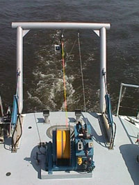
Hydrographers measure & describe bodies of water

Side scan sonar units are towed in the water, often behind the vessel, to gather data for navigation charts.
Hydrography is the science that deals with the measurement and description of the physical features of bodies of water and the land areas that are affected by those bodies of water.
A hydrographic survey may be conducted to support a variety of activities: nautical charting, port and harbor maintenance (dredging), coastal engineering (beach erosion and replenishment studies), coastal zone management, and offshore resource development.
The one data type common to all hydrographic surveys is water depth. Of additional concern to most surveys is the nature of the sea-floor material (i.e., sand, mud, rock) due to its implications for anchoring, dredging, structure construction, pipeline and cable routing, and fisheries habitat.
The primary use of hydrographic surveys is for nautical charting.
For more information:
Office of Coast Survey
Sea-floor Mapping, NOS Education

