Spot Forecasts
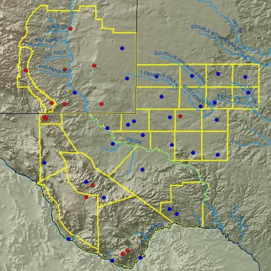
Click on Map Below for Detailed Forecasts
Click in a zone for that specific zone forecast.Click on a red dot for the RAWS point forecast matrix (PFW).
Click on a blue dot for the ASOS point forecast matrix (PFM).
Local Observations
- 8 Mile Draw, NM (north of Roswell)
- Artesia, NM
- Barnhart, TX
- Batdraw, NM (Carlsbad Caverns National Park)
- The Bowl, TX (Guadalupe Mountains National Park)
- Caprock, NM (near Maljamar)
- Chisos Basin, TX (Big Bend National Park)
- Cedar, TX (north of Amarillo)
- Dunken, NM (southwest Chaves County)
- Fort Davis, TX
- Marfa, TX
- Mayhill, NM
- Mescal, NM (east of Tularosa)
- Midland, TX
- Panther Junction, TX
- Pinery, TX (Guadalupe Mountains National Park)
- Paduca, NM (west of Eunice)
- Queen, NM (southwest of Carlsbad)
- Smokey Bear, NM (near Ruidoso)
Local Graphics Observations
Forecast Graphics
Regional Fire Weather Forecasts
- West Texas and Southeast New Mexico Fire Weather Forecast - NWS Midland
- West Texas and Southeast New Mexico Fire Weather Point Forecast (PFW) - NWS Midland
- West Central Texas Fire Weather Forecast - NWS San Angelo
- Far West Texas and Southern New Mexico Fire Weather Forecast - NWS El Past/Santa Teresa
- Northern and Central New Mexico Fire Weather Forecast - NWS Albuquerque
- Northern Texas Oklahoma Panhandles Fire Weather Forecast - NWS Amarillo
- Southern Plains Texas Panhandle Fire Weather Forecast - NWS Lubbock
- Northeast Texas Fire Weather Forecast - NWS Fort Worth
- South Central Texas Fire Weather Forecast - NWS New Braunfels
- Boise Long Range Outlooks
- Storm Prediction Center National Fire Weather Outlook
Regional Fire Weather Watch / Red Flag Warning
- West Texas and Southeast New Mexico Fire Weather Forecast - NWS Midland
- West Central Texas Fire Weather Forecast - NWS San Angelo
- Far West Texas and Southern New Mexico Fire Weather Forecast - NWS El Paso/Santa Teresa
- Northern and Central New Mexico Fire Weather Forecast - NWS Albuquerque
- Northern Texas Oklahoma Panhandles Fire Weather Forecast - NWS Amarillo
- Southern Plains Texas Panhandle Fire Weather Forecast - NWS Lubbock
- Northeast Texas Fire Weather Forecast - NWS Fort Worth
- South Central Texas Fire Weather Forecast - NWS New Braunfels
Annual Operating Plans
National Observations
WildFire Assessment Tools
Special Projects
Additional Resources